Property Record
5301 Woolridge Rd, Moseley, VA 23120

This Property Is For Sale
NEARBY LISTINGS FOR SALE OR LEASE
-
-
-
-
No Photo
-
-
-
-
View all Moseley listings for sale on LoopNet.com
Property Detail
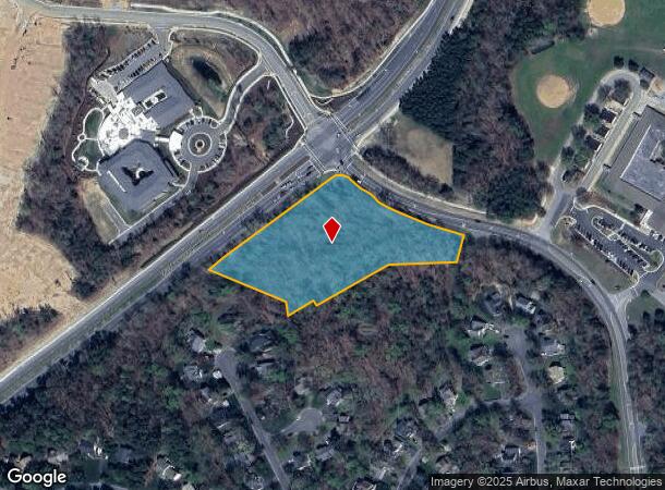
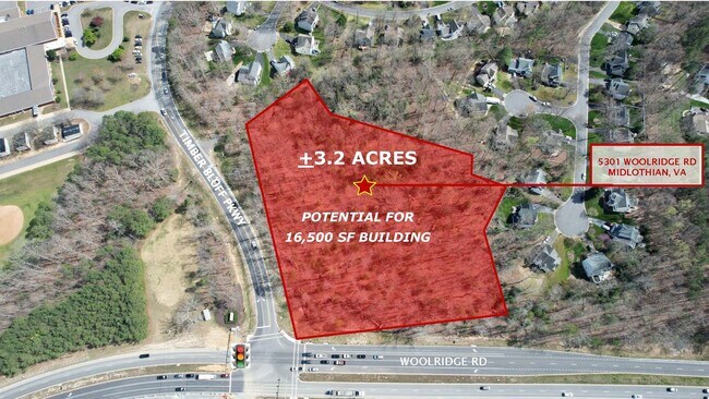
5301 Woolridge Rd
Richmond, VA
S Of Woolridge Rd Parcel 2
717-67-92-07-100-000
S OF WOOLRIDGE RD PARCEL 2
Commercialnec
Chesterfield
X
Virginia
51145C0300C
3.17 AC
2025
Rt 288 Corridor
2025
Richmond VA
101003
DEMOGRAPHICS near 5301 Woolridge Rd
1 Mile
3 Mile
5 Mile
2024 Total Population
6,219
51,680
100,935
2029 Population
6,806
57,184
111,683
Pop Growth 2024-2029
+ 9.44%
+ 10.65%
+ 10.65%
Average Age
39
39
39
2024 Total Households
2,135
17,897
35,972
HH Growth 2024-2029
+ 9.41%
+ 10.58%
+ 10.66%
Median Household Inc
$125,366
$127,466
$115,920
Avg Household Size
2.90
2.90
2.80
2024 Avg HH Vehicles
2.00
2.00
2.00
Median Home Value
$354,873
$379,918
$365,218
Median Year Built
1992
1998
2000
Nearby Places
Map Layers
Map Styles
 Street
 Aerial
- Restaurants
- Banks
- Shops
- Fitness
- Groceries
Nearby Properties
Address
Land Use
TOTAL SIZE
Lot Size
Zoning
Address
Land Use
TOTAL SIZE
Lot Size
Zoning
257,400 SF
85.42 AC
A - AGRICU
Address
Land Use
TOTAL SIZE
Lot Size
Zoning
318,965 SF
9.34 AC
C3 - COMMU
Address
Land Use
TOTAL SIZE
Lot Size
Zoning
151,510 SF
49.43 AC
R7 - SINGL
Address
Land Use
TOTAL SIZE
Lot Size
Zoning
95,857 SF
24.56 AC
C3 - COMMU
Address
Land Use
TOTAL SIZE
Lot Size
Zoning
89,300 SF
32.90 AC
O2 - CORP
Address
Land Use
TOTAL SIZE
Lot Size
Zoning
176,592 SF
9.70 AC
RMF - RES,
Address
Land Use
TOTAL SIZE
Lot Size
Zoning
64,809 SF
16.15 AC
O2 - CORP
Address
Land Use
TOTAL SIZE
Lot Size
Zoning
100 SF
15 AC
O2 - CORP
Address
Land Use
TOTAL SIZE
Lot Size
Zoning
40,308 SF
27.28 AC
C3 - COMMU
Address
Land Use
TOTAL SIZE
Lot Size
Zoning
53,900 SF
7.70 AC
R12 - SING
Address
Land Use
TOTAL SIZE
Lot Size
Zoning
188,736 SF
20.51 AC
C3 - COMMU
Address
Land Use
TOTAL SIZE
Lot Size
Zoning
58,250 SF
21.74 AC
I1 - LT IN
Address
Land Use
TOTAL SIZE
Lot Size
Zoning
116,542 SF
38.82 AC
R7 - SINGL
Address
Land Use
TOTAL SIZE
Lot Size
Zoning
10,675 SF
5.83 AC
C3 - COMMU
Address
Land Use
TOTAL SIZE
Lot Size
Zoning
50,668 SF
8.29 AC
C3 - COMMU
Address
Land Use
TOTAL SIZE
Lot Size
Zoning
73,969 SF
24.40 AC
R9 - SINGL
Address
Land Use
TOTAL SIZE
Lot Size
Zoning
64,972 SF
9.89 AC
C3 - COMMU
Address
Land Use
TOTAL SIZE
Lot Size
Zoning
135,556 SF
18.01 AC
C5 - GEN B
Address
Land Use
TOTAL SIZE
Lot Size
Zoning
34,844 SF
4 AC
O2 - CORP
Address
Land Use
TOTAL SIZE
Lot Size
Zoning
68,933 SF
14.64 AC
R9 - SINGL
Address
Land Use
TOTAL SIZE
Lot Size
Zoning
7,700 SF
4.78 AC
C2 - NBHD
Address
Land Use
TOTAL SIZE
Lot Size
Zoning
6,943 SF
20.05 AC
I1 - LT IN
Address
Land Use
TOTAL SIZE
Lot Size
Zoning
1,778 SF
5.49 AC
A - AGRICU
Address
Land Use
TOTAL SIZE
Lot Size
Zoning
45,800 SF
31.66 AC
A - AGRICU
Address
Land Use
TOTAL SIZE
Lot Size
Zoning
39,996 SF
4.93 AC
C3 - COMMU
Address
Land Use
TOTAL SIZE
Lot Size
Zoning
235.15 AC
R9 - SINGL
Address
Land Use
TOTAL SIZE
Lot Size
Zoning
70,426 SF
13.53 AC
R7 - SINGL
Address
Land Use
TOTAL SIZE
Lot Size
Zoning
64,180 SF
7.19 AC
C3 - COMMU
Address
Land Use
TOTAL SIZE
Lot Size
Zoning
82,787 SF
5.28 AC
C5 - GEN B
Address
Land Use
TOTAL SIZE
Lot Size
Zoning
64,443 SF
6.35 AC
C3 - COMMU
The World's #1 Commercial Real Estate Marketplace
Connect with us
© 2025 CoStar Group
The information above has been obtained from sources believed reliable. While we do not doubt its accuracy we have not verified it and make no guarantee, warranty or representation about it. It is your responsibility to independently confirm its accuracy and completeness. Any projections, opinions, assumptions, or estimates used are for example only and do not represent the current or future performance of the property. The value of this transaction to you depends on tax and other factors which should be evaluated by your tax, financial, and legal advisors. You and your advisors should conduct a careful, independent investigation of the property to determine to your satisfaction the suitability of the property for your needs.