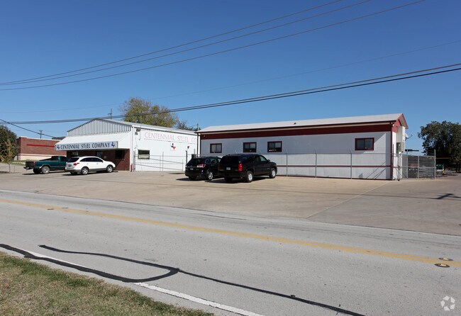
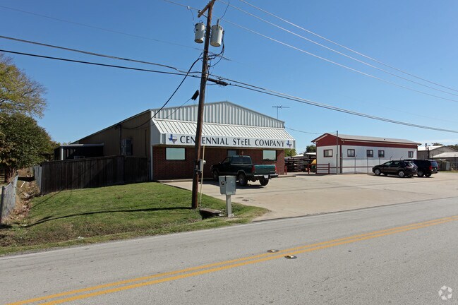
Property Record
5304 Dexham Rd, Rowlett, TX 75088

Property Detail
5304 Dexham Rd
65022559010820000
REASON CRIST ABST 225 PG 590 PT TR 82 ACS 1.035 VOL86237/4139 EX120586 CO-DALLAS 5905900108200 36502255901
Lightindustrial
DALLAS
Z94
Texas
B and X Area of moderate flood hazard, usually the area between the limits of the 100-year and 500-year floods.
1.03 AC
2025
NE Dallas/Garland
2025
Dallas/Ft Worth
018133
Dallas-Fort Worth-Arlington, TX
4,000 SF
NEARBY LISTINGS FOR SALE OR LEASE
DEMOGRAPHICS near 5304 Dexham Rd
1 mile
3 mile
5 mile
2025 Total Population
7,097
80,387
261,182
2030 Population
7,246
82,660
270,077
Pop Growth 2025-2030
+ 2.10%
+ 2.83%
+ 3.41%
Average Age
39
39
38
2025 Total Households
2,388
25,697
86,568
HH Growth 2025-2030
+ 2.14%
+ 2.90%
+ 3.49%
Median Household Inc
$115,120
$88,909
$85,036
Avg Household Size
3.00
3.10
3.00
2025 Avg HH Vehicles
2.00
2.00
2.00
Median Home Value
$361,352
$321,560
$307,768
Median Year Built
1987
1986
1984
Nearby Places
Map Layers
Map Styles
 Street
 Aerial
Layers
 Traffic
 Biking
Places
Listings with unknown addresses are not visible on the map
- Restaurants
- Banks
- Shops
- Fitness
- Groceries
PUBLIC TRANSPORTATION
AIRPORT
Dallas Love Field
Drive
Walk
Distance
Dallas Love Field
39 min
20.5 mi
Dallas-Fort Worth International
Drive
Walk
Distance
Dallas-Fort Worth International
46 min
32.7 mi
Nearby Properties
Address
Land Use
TOTAL SIZE
Lot Size
Zoning
Address
Land Use
TOTAL SIZE
Lot Size
Zoning
250,602 SF
4.99 AC
Z01
Address
Land Use
TOTAL SIZE
Lot Size
Zoning
261,164 SF
32.58 AC
Address
Land Use
TOTAL SIZE
Lot Size
Zoning
260,782 SF
16.30 AC
Z77
Address
Land Use
TOTAL SIZE
Lot Size
Zoning
427,231 SF
9.96 AC
Z38
Address
Land Use
TOTAL SIZE
Lot Size
Zoning
313,217 SF
3.61 AC
Z205
Address
Land Use
TOTAL SIZE
Lot Size
Zoning
228,458 SF
5.56 AC
Z236
Address
Land Use
TOTAL SIZE
Lot Size
Zoning
65,595 SF
19.22 AC
Z239
Address
Land Use
TOTAL SIZE
Lot Size
Zoning
259,280 SF
5.15 AC
Z01
Address
Land Use
TOTAL SIZE
Lot Size
Zoning
231,434 SF
11.27 AC
Z06
Address
Land Use
TOTAL SIZE
Lot Size
Zoning
178,125 SF
10.50 AC
Z77
Address
Land Use
TOTAL SIZE
Lot Size
Zoning
77,102 SF
27.47 AC
Z144
Address
Land Use
TOTAL SIZE
Lot Size
Zoning
60,593 SF
35.93 AC
Z06
Address
Land Use
TOTAL SIZE
Lot Size
Zoning
0.12 AC
Z63
Address
Land Use
TOTAL SIZE
Lot Size
Zoning
43,600 SF
62.86 AC
Z306
Address
Land Use
TOTAL SIZE
Lot Size
Zoning
138,865 SF
11.38 AC
Z239
Address
Land Use
TOTAL SIZE
Lot Size
Zoning
420,500 SF
33.25 AC
Address
Land Use
TOTAL SIZE
Lot Size
Zoning
133,249 SF
9.71 AC
Z239
Address
Land Use
TOTAL SIZE
Lot Size
Zoning
65,917 SF
7.99 AC
Z239
Address
Land Use
TOTAL SIZE
Lot Size
Zoning
261,000 SF
1 AC
Z318
Address
Land Use
TOTAL SIZE
Lot Size
Zoning
145,203 SF
12.86 AC
Z239
Address
Land Use
TOTAL SIZE
Lot Size
Zoning
119,397 SF
7.41 AC
Z160
Address
Land Use
TOTAL SIZE
Lot Size
Zoning
76,812 SF
9.22 AC
Z144
Address
Land Use
TOTAL SIZE
Lot Size
Zoning
226,800 SF
4.98 AC
Z340
Address
Land Use
TOTAL SIZE
Lot Size
Zoning
82,847 SF
4.87 AC
Z236
Address
Land Use
TOTAL SIZE
Lot Size
Zoning
78,017 SF
1.75 AC
Z236
Address
Land Use
TOTAL SIZE
Lot Size
Zoning
83,154 SF
14.39 AC
Z386
Address
Land Use
TOTAL SIZE
Lot Size
Zoning
58,217 SF
7.09 AC
Z390
Address
Land Use
TOTAL SIZE
Lot Size
Zoning
140,000 SF
12.76 AC
Address
Land Use
TOTAL SIZE
Lot Size
Zoning
141,200 SF
10.81 AC
Address
Land Use
TOTAL SIZE
Lot Size
Zoning
150,926 SF
9.33 AC
The World's #1 Commercial Real Estate Marketplace
Connect with us
© 2026 CoStar Group
The information above has been obtained from sources believed reliable. While we do not doubt its accuracy we have not verified it and make no guarantee, warranty or representation about it. It is your responsibility to independently confirm its accuracy and completeness. Any projections, opinions, assumptions, or estimates used are for example only and do not represent the current or future performance of the property. The value of this transaction to you depends on tax and other factors which should be evaluated by your tax, financial, and legal advisors. You and your advisors should conduct a careful, independent investigation of the property to determine to your satisfaction the suitability of the property for your needs.