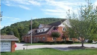
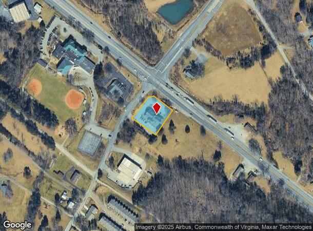
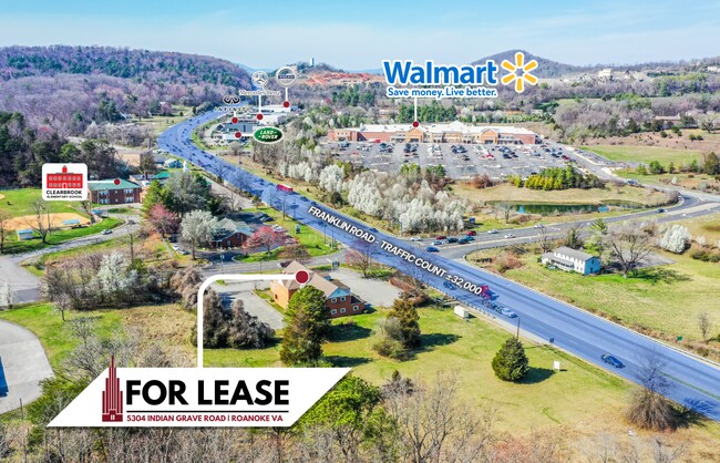
Property Record
5304 Indian Grave Rd, Roanoke, VA 24018
NEARBY LISTINGS FOR SALE OR LEASE
Property Detail
5304 Indian Grave Rd
Roanoke, VA
Rt 220 South Commercial
098.02-02-01.01-0000
LT A-1 RESUBD & COMB FOR INDIAN GRAVE PART & JOEL & ANN SHEPHERD OFF INDIAN GRAV
Medicalbuilding
Roanoke
X
Virginia
51067C0055C
a-1
2025
0.71 AC
2025
Southwest Roanoke
030900
Roanoke
8,118 SF
DEMOGRAPHICS near 5304 Indian Grave Rd
1 Mile
3 Mile
5 Mile
2024 Total Population
720
20,016
72,746
2029 Population
721
19,891
71,841
Pop Growth 2024-2029
+ 0.14%
(0.62%)
(1.24%)
Average Age
45
44
42
2024 Total Households
325
9,064
32,936
HH Growth 2024-2029
0.00%
(0.64%)
(1.30%)
Median Household Inc
$42,560
$71,971
$62,540
Avg Household Size
2.20
2.20
2.10
2024 Avg HH Vehicles
2.00
2.00
2.00
Median Home Value
$358,035
$302,560
$246,032
Median Year Built
1982
1978
1966
Nearby Places
Map Layers
Map Styles
 Street
 Aerial
- Restaurants
- Banks
- Shops
- Fitness
- Groceries
PUBLIC TRANSPORTATION
COMMUTER RAIL
DRIVE
WALK
Distance
11 min
6.4 mi
AIRPORT
Roanoke/Blacksburg Regional (Woodrum Field)
DRIVE
WALK
Distance
Roanoke/Blacksburg Regional (Woodrum Field)
20 min
11.8 mi
Nearby Properties
Address
Land Use
TOTAL SIZE
Lot Size
Zoning
Address
Land Use
TOTAL SIZE
Lot Size
Zoning
149,370 SF
40 AC
R1
Address
Land Use
TOTAL SIZE
Lot Size
Zoning
10,030 SF
32.18 AC
RMF
Address
Land Use
TOTAL SIZE
Lot Size
Zoning
10,143 SF
25.30 AC
R3
Address
Land Use
TOTAL SIZE
Lot Size
Zoning
2.75 AC
Address
Land Use
TOTAL SIZE
Lot Size
Zoning
6,298 SF
43.38 AC
C2
Address
Land Use
TOTAL SIZE
Lot Size
Zoning
146,345 SF
5.97 AC
MX
Address
Land Use
TOTAL SIZE
Lot Size
Zoning
56,496 SF
19.14 AC
I2C
Address
Land Use
TOTAL SIZE
Lot Size
Zoning
187,130 SF
29.96 AC
C2
Address
Land Use
TOTAL SIZE
Lot Size
Zoning
11,529 SF
9.78 AC
R4
Address
Land Use
TOTAL SIZE
Lot Size
Zoning
583 SF
7.16 AC
INPUD
Address
Land Use
TOTAL SIZE
Lot Size
Zoning
11,529 SF
9.75 AC
R4
Address
Land Use
TOTAL SIZE
Lot Size
Zoning
7.75 AC
Address
Land Use
TOTAL SIZE
Lot Size
Zoning
71,400 SF
10.24 AC
R1
Address
Land Use
TOTAL SIZE
Lot Size
Zoning
57,615 SF
4.06 AC
MX
Address
Land Use
TOTAL SIZE
Lot Size
Zoning
136,895 SF
19.45 AC
C2C
Address
Land Use
TOTAL SIZE
Lot Size
Zoning
38,958 SF
7.99 AC
MX
Address
Land Use
TOTAL SIZE
Lot Size
Zoning
47,949 SF
26.63 AC
C2S
Address
Land Use
TOTAL SIZE
Lot Size
Zoning
79,605 SF
2.50 AC
C2C
Address
Land Use
TOTAL SIZE
Lot Size
Zoning
9,792 SF
6.72 AC
RMF
Address
Land Use
TOTAL SIZE
Lot Size
Zoning
27,384 SF
10.23 AC
R4
Address
Land Use
TOTAL SIZE
Lot Size
Zoning
87,332 SF
4.60 AC
CLS
Address
Land Use
TOTAL SIZE
Lot Size
Zoning
12,345 SF
4.85 AC
RMF
Address
Land Use
TOTAL SIZE
Lot Size
Zoning
71,819 SF
21.12 AC
ARS
Address
Land Use
TOTAL SIZE
Lot Size
Zoning
98,823 SF
3.76 AC
C2
Address
Land Use
TOTAL SIZE
Lot Size
Zoning
106,511 SF
10.58 AC
CG
Address
Land Use
TOTAL SIZE
Lot Size
Zoning
49,094 SF
5.02 AC
CLS
Address
Land Use
TOTAL SIZE
Lot Size
Zoning
4,000 SF
10.33 AC
R4
Address
Land Use
TOTAL SIZE
Lot Size
Zoning
26,438 SF
4.81 AC
C2
Address
Land Use
TOTAL SIZE
Lot Size
Zoning
4.22 AC
INPUD
Address
Land Use
TOTAL SIZE
Lot Size
Zoning
51,923 SF
3.43 AC
ROS/IN
The World's #1 Commercial Real Estate Marketplace
Connect with us
© 2026 CoStar Group
The information above has been obtained from sources believed reliable. While we do not doubt its accuracy we have not verified it and make no guarantee, warranty or representation about it. It is your responsibility to independently confirm its accuracy and completeness. Any projections, opinions, assumptions, or estimates used are for example only and do not represent the current or future performance of the property. The value of this transaction to you depends on tax and other factors which should be evaluated by your tax, financial, and legal advisors. You and your advisors should conduct a careful, independent investigation of the property to determine to your satisfaction the suitability of the property for your needs.