Property Record
5305 E Main St, Mesa, AZ 85205
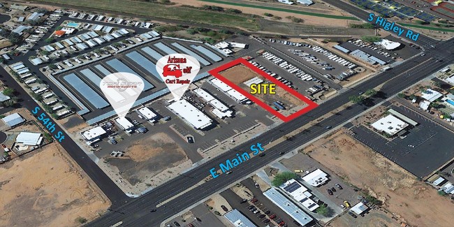

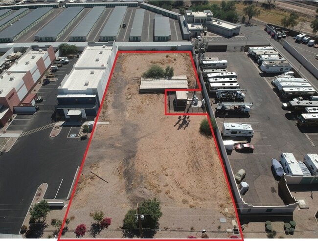

This Property Is For Sale
Property Detail
5305 E Main St
Phoenix-Mesa-Chandler, AZ
54TH STREET BUSINESS PARK MCR 1301-06
141-51-293
MARICOPA
Commercialacreage
Arizona
GC
1
C and X Area of minimal flood hazard, usually depicted on FIRMs as above the 500-year flood level.
0.80 AC
2025
Mesa East
2025
Phoenix
422625
NEARBY LISTINGS FOR SALE OR LEASE
DEMOGRAPHICS near 5305 E Main St
1 mile
3 mile
5 mile
2024 Total Population
16,483
123,235
311,563
2029 Population
18,196
134,425
338,252
Pop Growth 2024-2029
+ 10.39%
+ 9.08%
+ 8.57%
Average Age
57
46
43
2024 Total Households
8,285
54,012
122,797
HH Growth 2024-2029
+ 11.23%
+ 9.55%
+ 9.02%
Median Household Inc
$49,514
$61,927
$70,823
Avg Household Size
1.90
2.20
2.50
2024 Avg HH Vehicles
1.00
2.00
2.00
Median Home Value
$147,201
$287,025
$337,772
Median Year Built
1984
1987
1988
Nearby Places
Map Layers
Map Styles
 Street
 Aerial
Transit
 Traffic
 Biking
Places
Listings with unknown addresses are not visible on the map
- Restaurants
- Banks
- Shops
- Fitness
- Groceries
PUBLIC TRANSPORTATION
AIRPORT
Phoenix-Mesa Gateway
Drive
Walk
Distance
Phoenix-Mesa Gateway
20 min
10.7 mi
Phoenix Sky Harbor International
Drive
Walk
Distance
Phoenix Sky Harbor International
32 min
22.6 mi
Nearby Properties
Address
Land Use
TOTAL SIZE
Lot Size
Zoning
Address
Land Use
TOTAL SIZE
Lot Size
Zoning
1,522,034 SF
32.67 AC
C-N
Address
Land Use
TOTAL SIZE
Lot Size
Zoning
981,158 SF
43.42 AC
C-G
Address
Land Use
TOTAL SIZE
Lot Size
Zoning
53,910 SF
4.98 AC
C-G
Address
Land Use
TOTAL SIZE
Lot Size
Zoning
1,691,248 SF
528.80 AC
I-1
Address
Land Use
TOTAL SIZE
Lot Size
Zoning
324,534 SF
50.86 AC
PF
Address
Land Use
TOTAL SIZE
Lot Size
Zoning
441,928 SF
17.31 AC
RM3
Address
Land Use
TOTAL SIZE
Lot Size
Zoning
271,098 SF
142.75 AC
PF
Address
Land Use
TOTAL SIZE
Lot Size
Zoning
461,845 SF
21.62 AC
LI
Address
Land Use
TOTAL SIZE
Lot Size
Zoning
279,338 SF
39.90 AC
PF
Address
Land Use
TOTAL SIZE
Lot Size
Zoning
18.75 AC
PF
Address
Land Use
TOTAL SIZE
Lot Size
Zoning
711,933 SF
45.84 AC
Address
Land Use
TOTAL SIZE
Lot Size
Zoning
129,201 SF
24.65 AC
LI
Address
Land Use
TOTAL SIZE
Lot Size
Zoning
160,296 SF
33.63 AC
PF
Address
Land Use
TOTAL SIZE
Lot Size
Zoning
269,763 SF
17.49 AC
M-H
Address
Land Use
TOTAL SIZE
Lot Size
Zoning
344,619 SF
13.85 AC
M-H
Address
Land Use
TOTAL SIZE
Lot Size
Zoning
140,141 SF
37.70 AC
PF
Address
Land Use
TOTAL SIZE
Lot Size
Zoning
425,158 SF
23.71 AC
M-H
Address
Land Use
TOTAL SIZE
Lot Size
Zoning
98,852 SF
1.23 AC
C-G
Address
Land Use
TOTAL SIZE
Lot Size
Zoning
233,188 SF
7.34 AC
RM4
Address
Land Use
TOTAL SIZE
Lot Size
Zoning
307,545 SF
17.61 AC
M-H
Address
Land Use
TOTAL SIZE
Lot Size
Zoning
208,046 SF
23.54 AC
I-1
Address
Land Use
TOTAL SIZE
Lot Size
Zoning
219,041 SF
5.71 AC
I-1
Address
Land Use
TOTAL SIZE
Lot Size
Zoning
8.82 AC
Address
Land Use
TOTAL SIZE
Lot Size
Zoning
349,318 SF
18.47 AC
M-H
Address
Land Use
TOTAL SIZE
Lot Size
Zoning
359,204 SF
40.94 AC
LI
Address
Land Use
TOTAL SIZE
Lot Size
Zoning
267,380 SF
17.08 AC
M-H
Address
Land Use
TOTAL SIZE
Lot Size
Zoning
225,660 SF
10.36 AC
M-H
Address
Land Use
TOTAL SIZE
Lot Size
Zoning
212,942 SF
12.80 AC
M-H
Address
Land Use
TOTAL SIZE
Lot Size
Zoning
160,843 SF
22.07 AC
PF
Address
Land Use
TOTAL SIZE
Lot Size
Zoning
266,240 SF
9.75 AC
M-H
The World's #1 Commercial Real Estate Marketplace
Connect with us
© 2026 CoStar Group
The information above has been obtained from sources believed reliable. While we do not doubt its accuracy we have not verified it and make no guarantee, warranty or representation about it. It is your responsibility to independently confirm its accuracy and completeness. Any projections, opinions, assumptions, or estimates used are for example only and do not represent the current or future performance of the property. The value of this transaction to you depends on tax and other factors which should be evaluated by your tax, financial, and legal advisors. You and your advisors should conduct a careful, independent investigation of the property to determine to your satisfaction the suitability of the property for your needs.