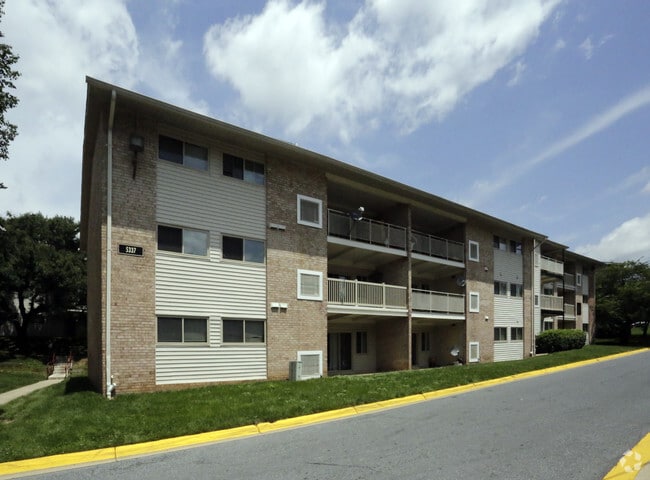
Property Record
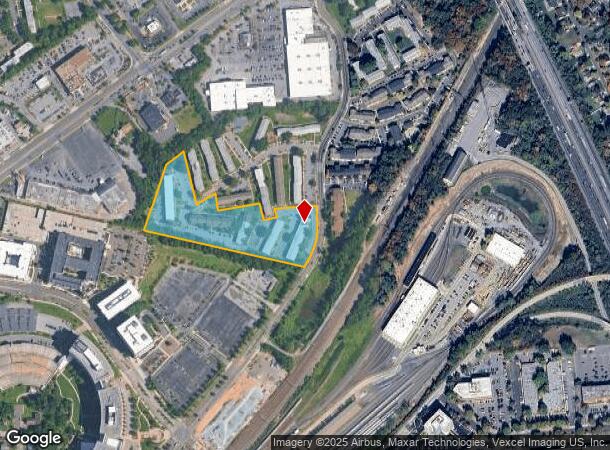
5306 85Th Ave, New Carrollton, MD 20784

NEARBY LISTINGS FOR SALE OR LEASE
-
-
View all New Carrollton listings for sale on LoopNet.com
Property Detail
5306 85Th Ave
20-2180008
Carrollan Prcl #3
Apartment
PT PAR 2 EQ 7.6177 AC
X
Prince George's
24033C0155E
Maryland
2024
7.61 AC
2025
New Carrollton
803612
Washington, DC
108,864 SF
Washington-Arlington-Alexandria, DC-VA-MD-WV
DEMOGRAPHICS near 5306 85Th Ave
1 Mile
3 Mile
5 Mile
2024 Total Population
15,916
141,293
321,082
2029 Population
15,513
137,849
313,094
Pop Growth 2024-2029
(2.53%)
(2.44%)
(2.49%)
Average Age
38
38
38
2024 Total Households
5,481
44,246
108,914
HH Growth 2024-2029
(2.41%)
(2.54%)
(2.64%)
Median Household Inc
$71,777
$81,118
$83,700
Avg Household Size
2.90
3.10
2.80
2024 Avg HH Vehicles
2.00
2.00
2.00
Median Home Value
$333,048
$350,626
$373,369
Median Year Built
1967
1969
1972
Nearby Places
Map Layers
Map Styles
 Street
 Aerial
- Restaurants
- Banks
- Shops
- Fitness
- Groceries
PUBLIC TRANSPORTATION
TRANSIT/SUBWAY
New Carrollton (Orange Line - Washington Metropolitan Area Transit Authority Metrorail (Metrorail))
DRIVE
WALK
Distance
New Carrollton (Orange Line - Washington Metropolitan Area Transit Authority Metrorail (Metrorail))
1 min
10 min
0.5 mi
COMMUTER RAIL
New Carrollton (PENN - WASHINGTON - Maryland Area Regional Commuter Trains (The MARC), Penn Line - Maryland Area Regional Commuter Trains (The MARC))
DRIVE
WALK
Distance
New Carrollton (PENN - WASHINGTON - Maryland Area Regional Commuter Trains (The MARC), Penn Line - Maryland Area Regional Commuter Trains (The MARC))
1 min
9 min
0.5 mi
New Carrollton Marc Nb (PENN - WASHINGTON - Maryland Transit Administration)
DRIVE
WALK
Distance
New Carrollton Marc Nb (PENN - WASHINGTON - Maryland Transit Administration)
1 min
10 min
0.5 mi
AIRPORT
Ronald Reagan Washington Ntl
DRIVE
WALK
Distance
Ronald Reagan Washington Ntl
26 min
16.0 mi
Baltimore/Washington International Thurgood Marshall
DRIVE
WALK
Distance
Baltimore/Washington International Thurgood Marshall
35 min
23.2 mi
Freight Ports
Port of Baltimore
DRIVE
WALK
Distance
Port of Baltimore
45 min
29.7 mi
Nearby Properties
Address
Land Use
TOTAL SIZE
Lot Size
Zoning
Address
Land Use
TOTAL SIZE
Lot Size
Zoning
1,631,415 SF
24.33 AC
RTOHC
Address
Land Use
TOTAL SIZE
Lot Size
Zoning
413,915 SF
39.86 AC
IE
Address
Land Use
TOTAL SIZE
Lot Size
Zoning
337,216 SF
1.18 AC
RTOHC
Address
Land Use
TOTAL SIZE
Lot Size
Zoning
290,728 SF
29.27 AC
RSF95
Address
Land Use
TOTAL SIZE
Lot Size
Zoning
1,082,460 SF
9.28 AC
RTOHC
Address
Land Use
TOTAL SIZE
Lot Size
Zoning
264,093 SF
22.74 AC
CGO
Address
Land Use
TOTAL SIZE
Lot Size
Zoning
27.07 AC
RMF20
Address
Land Use
TOTAL SIZE
Lot Size
Zoning
2.35 AC
RTOHC
Address
Land Use
TOTAL SIZE
Lot Size
Zoning
305,375 SF
39.83 AC
RSF65
Address
Land Use
TOTAL SIZE
Lot Size
Zoning
327,240 SF
1.72 AC
RTOHC
Address
Land Use
TOTAL SIZE
Lot Size
Zoning
14.85 AC
RMF20
Address
Land Use
TOTAL SIZE
Lot Size
Zoning
182,907 SF
39.78 AC
RR
Address
Land Use
TOTAL SIZE
Lot Size
Zoning
256,896 SF
34.96 AC
RSF65
Address
Land Use
TOTAL SIZE
Lot Size
Zoning
368,038 SF
12.87 AC
IE
Address
Land Use
TOTAL SIZE
Lot Size
Zoning
4,704 SF
7.20 AC
RMF48
Address
Land Use
TOTAL SIZE
Lot Size
Zoning
194,850 SF
8.90 AC
LTOE
Address
Land Use
TOTAL SIZE
Lot Size
Zoning
17.68 AC
RMF20
Address
Land Use
TOTAL SIZE
Lot Size
Zoning
2.09 AC
RTOHC
Address
Land Use
TOTAL SIZE
Lot Size
Zoning
218,628 SF
1.45 AC
RTOHC
Address
Land Use
TOTAL SIZE
Lot Size
Zoning
300,000 SF
2.82 AC
RTOHC
Address
Land Use
TOTAL SIZE
Lot Size
Zoning
169,431 SF
43.81 AC
CGO
Address
Land Use
TOTAL SIZE
Lot Size
Zoning
108,864 SF
0.91 AC
RTOHC
Address
Land Use
TOTAL SIZE
Lot Size
Zoning
226,810 SF
21.40 AC
RSF65
Address
Land Use
TOTAL SIZE
Lot Size
Zoning
2.35 AC
RTOHC
Address
Land Use
TOTAL SIZE
Lot Size
Zoning
10.81 AC
RMF48
Address
Land Use
TOTAL SIZE
Lot Size
Zoning
57,288 SF
6.94 AC
TACE
Address
Land Use
TOTAL SIZE
Lot Size
Zoning
7.65 AC
RMF20
Address
Land Use
TOTAL SIZE
Lot Size
Zoning
329,080 SF
15.31 AC
IE
Address
Land Use
TOTAL SIZE
Lot Size
Zoning
21.47 AC
LTOE
Address
Land Use
TOTAL SIZE
Lot Size
Zoning
272,790 SF
8.35 AC
LTOE
The World's #1 Commercial Real Estate Marketplace
Connect with us
© 2026 CoStar Group
The information above has been obtained from sources believed reliable. While we do not doubt its accuracy we have not verified it and make no guarantee, warranty or representation about it. It is your responsibility to independently confirm its accuracy and completeness. Any projections, opinions, assumptions, or estimates used are for example only and do not represent the current or future performance of the property. The value of this transaction to you depends on tax and other factors which should be evaluated by your tax, financial, and legal advisors. You and your advisors should conduct a careful, independent investigation of the property to determine to your satisfaction the suitability of the property for your needs.