Property Record
5309 Roberts Rd, Hilliard, OH 43026
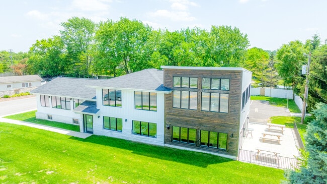


Property Detail
5309 Roberts Rd
560-154699
5309 ROBERTS RD ENTRY 6554 0.483 ACRE
Officebuilding
Franklin
B and X Area of moderate flood hazard, usually the area between the limits of the 100-year and 500-year floods.
Ohio
2024
0.48 AC
2025
Hilliard
007965
Columbus
3,608 SF
Columbus, OH
NEARBY LISTINGS FOR SALE OR LEASE
DEMOGRAPHICS near 5309 Roberts Rd
1 mile
3 mile
5 mile
2025 Total Population
18,915
72,623
188,876
2030 Population
19,240
74,193
193,784
Pop Growth 2025-2030
+ 1.72%
+ 2.16%
+ 2.60%
Average Age
35
37
37
2025 Total Households
7,119
29,315
76,539
HH Growth 2025-2030
+ 1.85%
+ 2.33%
+ 2.67%
Median Household Inc
$98,389
$97,429
$92,666
Avg Household Size
2.60
2.40
2.40
2025 Avg HH Vehicles
2.00
2.00
2.00
Median Home Value
$312,364
$326,409
$342,697
Median Year Built
1995
1994
1991
Nearby Places
Map Layers
Map Styles
 Street
 Aerial
Layers
 Traffic
 Biking
Places
Listings with unknown addresses are not visible on the map
- Restaurants
- Banks
- Shops
- Fitness
- Groceries
PUBLIC TRANSPORTATION
AIRPORT
John Glenn Columbus International
Drive
Walk
Distance
John Glenn Columbus International
25 min
17.3 mi
Rickenbacker International
Drive
Walk
Distance
Rickenbacker International
29 min
21.9 mi
Freight Ports
Port of Toledo
Drive
Walk
Distance
Port of Toledo
181 min
133.8 mi
SALE & LEASE HISTORY
LISTING DATE
SALE/LEASE

Jun 30, 2022
For Sale
Nearby Properties
Address
Land Use
TOTAL SIZE
Lot Size
Zoning
Address
Land Use
TOTAL SIZE
Lot Size
Zoning
417,762 SF
119.53 AC
Address
Land Use
TOTAL SIZE
Lot Size
Zoning
327,525 SF
70.58 AC
Address
Land Use
TOTAL SIZE
Lot Size
Zoning
529,001 SF
0.15 AC
Address
Land Use
TOTAL SIZE
Lot Size
Zoning
961,554 SF
75.09 AC
Address
Land Use
TOTAL SIZE
Lot Size
Zoning
538,680 SF
32.49 AC
Address
Land Use
TOTAL SIZE
Lot Size
Zoning
91,413 SF
0.14 AC
Address
Land Use
TOTAL SIZE
Lot Size
Zoning
255,902 SF
8.15 AC
Address
Land Use
TOTAL SIZE
Lot Size
Zoning
155,280 SF
0.23 AC
Address
Land Use
TOTAL SIZE
Lot Size
Zoning
82,510 SF
15.80 AC
Address
Land Use
TOTAL SIZE
Lot Size
Zoning
566,334 SF
58.62 AC
Address
Land Use
TOTAL SIZE
Lot Size
Zoning
96,602 SF
0.21 AC
Address
Land Use
TOTAL SIZE
Lot Size
Zoning
293,744 SF
20.12 AC
Address
Land Use
TOTAL SIZE
Lot Size
Zoning
98,316 SF
10.81 AC
Address
Land Use
TOTAL SIZE
Lot Size
Zoning
157,875 SF
0.19 AC
Address
Land Use
TOTAL SIZE
Lot Size
Zoning
40,500 SF
20.91 AC
Address
Land Use
TOTAL SIZE
Lot Size
Zoning
21,238 SF
14.67 AC
Address
Land Use
TOTAL SIZE
Lot Size
Zoning
149,424 SF
39.15 AC
Address
Land Use
TOTAL SIZE
Lot Size
Zoning
126,656 SF
15.83 AC
Address
Land Use
TOTAL SIZE
Lot Size
Zoning
429,544 SF
23.21 AC
Address
Land Use
TOTAL SIZE
Lot Size
Zoning
137,350 SF
11.01 AC
Address
Land Use
TOTAL SIZE
Lot Size
Zoning
67,133 SF
16.67 AC
Address
Land Use
TOTAL SIZE
Lot Size
Zoning
249,644 SF
7.15 AC
Address
Land Use
TOTAL SIZE
Lot Size
Zoning
55,758 SF
7.83 AC
Address
Land Use
TOTAL SIZE
Lot Size
Zoning
173,002 SF
7.16 AC
Address
Land Use
TOTAL SIZE
Lot Size
Zoning
395,835 SF
23.83 AC
Address
Land Use
TOTAL SIZE
Lot Size
Zoning
138,467 SF
2.77 AC
Address
Land Use
TOTAL SIZE
Lot Size
Zoning
199,790 SF
25.99 AC
Address
Land Use
TOTAL SIZE
Lot Size
Zoning
107,468 SF
16.05 AC
Address
Land Use
TOTAL SIZE
Lot Size
Zoning
125.87 AC
Address
Land Use
TOTAL SIZE
Lot Size
Zoning
81,516 SF
15.16 AC
The World's #1 Commercial Real Estate Marketplace
Connect with us
© 2026 CoStar Group
The information above has been obtained from sources believed reliable. While we do not doubt its accuracy we have not verified it and make no guarantee, warranty or representation about it. It is your responsibility to independently confirm its accuracy and completeness. Any projections, opinions, assumptions, or estimates used are for example only and do not represent the current or future performance of the property. The value of this transaction to you depends on tax and other factors which should be evaluated by your tax, financial, and legal advisors. You and your advisors should conduct a careful, independent investigation of the property to determine to your satisfaction the suitability of the property for your needs.