Property Record
531 Central Parkway Rd, Woodstock, IL 60098

NEARBY LISTINGS FOR SALE OR LEASE
-
-
View all Woodstock listings for sale on LoopNet.com
Property Detail
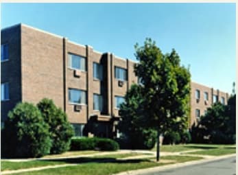
531 Central Parkway Rd
Chicago-Naperville-Elgin, IL-IN-WI
Todd Woods Addn
08-32-202-012
DOC 1995R0012153 LT 25 TODD WOODS ADDN UNIT 8
Commercialnec
McHenry
X
Illinois
17111C0179J
25
2024
2.23 AC
2024
Western McHenry County
870402
Chicago
DEMOGRAPHICS near 531 Central Parkway Rd
1 Mile
3 Mile
5 Mile
2024 Total Population
8,265
23,249
35,592
2029 Population
8,254
23,253
35,646
Pop Growth 2024-2029
(0.13%)
+ 0.02%
+ 0.15%
Average Age
39
41
40
2024 Total Households
2,951
8,856
13,348
HH Growth 2024-2029
(0.14%)
(0.02%)
+ 0.12%
Median Household Inc
$74,237
$74,537
$80,386
Avg Household Size
2.60
2.50
2.60
2024 Avg HH Vehicles
2.00
2.00
2.00
Median Home Value
$179,007
$193,874
$221,874
Median Year Built
1984
1978
1983
Nearby Places
Map Layers
Map Styles
 Street
 Aerial
- Restaurants
- Banks
- Shops
- Fitness
- Groceries
PUBLIC TRANSPORTATION
COMMUTER RAIL
Woodstock Station (Union Pacific Northwest Line - Northeast Illinois Regional Commuter Railroad (Metra))
DRIVE
WALK
Distance
Woodstock Station (Union Pacific Northwest Line - Northeast Illinois Regional Commuter Railroad (Metra))
4 min
1.8 mi
Freight Ports
Port Milwaukee
DRIVE
WALK
Distance
Port Milwaukee
90 min
66.4 mi
Nearby Properties
Address
Land Use
TOTAL SIZE
Lot Size
Zoning
Address
Land Use
TOTAL SIZE
Lot Size
Zoning
219,350 SF
19.83 AC
Address
Land Use
TOTAL SIZE
Lot Size
Zoning
129,755 SF
13.01 AC
Address
Land Use
TOTAL SIZE
Lot Size
Zoning
64,528 SF
9.51 AC
Address
Land Use
TOTAL SIZE
Lot Size
Zoning
50,749 SF
5.92 AC
Address
Land Use
TOTAL SIZE
Lot Size
Zoning
96,633 SF
3.97 AC
Address
Land Use
TOTAL SIZE
Lot Size
Zoning
164,167 SF
16.11 AC
Address
Land Use
TOTAL SIZE
Lot Size
Zoning
581,330 SF
15.02 AC
Address
Land Use
TOTAL SIZE
Lot Size
Zoning
148,917 SF
9.22 AC
Address
Land Use
TOTAL SIZE
Lot Size
Zoning
72,582 SF
3.74 AC
Address
Land Use
TOTAL SIZE
Lot Size
Zoning
45,876 SF
5.02 AC
Address
Land Use
TOTAL SIZE
Lot Size
Zoning
178,561 SF
19.09 AC
Address
Land Use
TOTAL SIZE
Lot Size
Zoning
12,699 SF
8 AC
Address
Land Use
TOTAL SIZE
Lot Size
Zoning
127,765 SF
7.91 AC
Address
Land Use
TOTAL SIZE
Lot Size
Zoning
2.78 AC
Address
Land Use
TOTAL SIZE
Lot Size
Zoning
24,968 SF
0.50 AC
Address
Land Use
TOTAL SIZE
Lot Size
Zoning
32,308 SF
4.58 AC
Address
Land Use
TOTAL SIZE
Lot Size
Zoning
130,669 SF
13.20 AC
Address
Land Use
TOTAL SIZE
Lot Size
Zoning
32,754 SF
0.11 AC
Address
Land Use
TOTAL SIZE
Lot Size
Zoning
Address
Land Use
TOTAL SIZE
Lot Size
Zoning
Address
Land Use
TOTAL SIZE
Lot Size
Zoning
22,724 SF
3.63 AC
Address
Land Use
TOTAL SIZE
Lot Size
Zoning
32,828 SF
1.68 AC
Address
Land Use
TOTAL SIZE
Lot Size
Zoning
24,164 SF
4.99 AC
Address
Land Use
TOTAL SIZE
Lot Size
Zoning
25,650 SF
0.19 AC
Address
Land Use
TOTAL SIZE
Lot Size
Zoning
17,973 SF
8.64 AC
Address
Land Use
TOTAL SIZE
Lot Size
Zoning
139,352 SF
29.32 AC
Address
Land Use
TOTAL SIZE
Lot Size
Zoning
47,637 SF
1.09 AC
Address
Land Use
TOTAL SIZE
Lot Size
Zoning
35,389 SF
4.44 AC
Address
Land Use
TOTAL SIZE
Lot Size
Zoning
The World's #1 Commercial Real Estate Marketplace
Connect with us
© 2026 CoStar Group
The information above has been obtained from sources believed reliable. While we do not doubt its accuracy we have not verified it and make no guarantee, warranty or representation about it. It is your responsibility to independently confirm its accuracy and completeness. Any projections, opinions, assumptions, or estimates used are for example only and do not represent the current or future performance of the property. The value of this transaction to you depends on tax and other factors which should be evaluated by your tax, financial, and legal advisors. You and your advisors should conduct a careful, independent investigation of the property to determine to your satisfaction the suitability of the property for your needs.