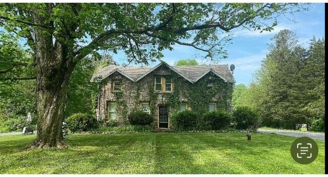
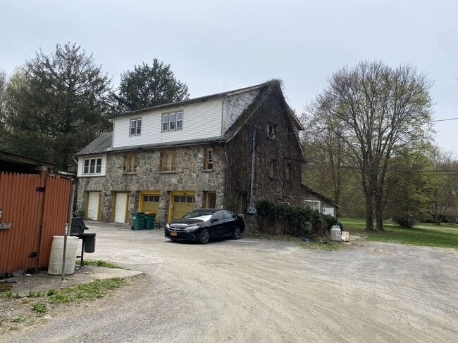
Property Record
531 Creek Rd, Poughkeepsie, NY 12601

NEARBY LISTINGS FOR SALE OR LEASE
-
-
View all Poughkeepsie listings for sale on LoopNet.com
Property Detail
531 Creek Rd
133200-6163-02-812965-0000
2.30 AC (S) 2002 0051
Multifamilydwelling
Dutchess
X
New York
36027C0269E
812
2025
2.30 AC
2024
Poughkeepsie
070401
Westchester/So Connecticut
4,884 SF
Dutchess County-Putnam County, NY
DEMOGRAPHICS near 531 Creek Rd
1 Mile
3 Mile
5 Mile
2024 Total Population
3,146
24,776
85,837
2029 Population
3,163
25,063
86,600
Pop Growth 2024-2029
+ 0.54%
+ 1.16%
+ 0.89%
Average Age
39
39
40
2024 Total Households
992
8,218
32,258
HH Growth 2024-2029
+ 0.30%
+ 1.17%
+ 0.99%
Median Household Inc
$89,428
$82,634
$66,907
Avg Household Size
2.40
2.30
2.30
2024 Avg HH Vehicles
2.00
2.00
2.00
Median Home Value
$267,441
$258,160
$271,235
Median Year Built
1967
1969
1964
Nearby Places
- Restaurants
- Banks
- Shops
- Fitness
- Groceries
PUBLIC TRANSPORTATION
COMMUTER RAIL
Poughkeepsie Station (Hudson Line - Metro-North Commuter Railroad Company (Metro-North))
DRIVE
WALK
Distance
Poughkeepsie Station (Hudson Line - Metro-North Commuter Railroad Company (Metro-North))
11 min
6.0 mi
AIRPORT
New York Stewart International
DRIVE
WALK
Distance
New York Stewart International
45 min
28.5 mi
Nearby Properties
Address
Land Use
TOTAL SIZE
Lot Size
Zoning
Address
Land Use
TOTAL SIZE
Lot Size
Zoning
539,228 SF
62.57 AC
IN
Address
Land Use
TOTAL SIZE
Lot Size
Zoning
314,927 SF
24.59 AC
IN
Address
Land Use
TOTAL SIZE
Lot Size
Zoning
4.99 AC
R2A
Address
Land Use
TOTAL SIZE
Lot Size
Zoning
246,913 SF
43.93 AC
IN
Address
Land Use
TOTAL SIZE
Lot Size
Zoning
181,295 SF
20.48 AC
IN
Address
Land Use
TOTAL SIZE
Lot Size
Zoning
317,644 SF
35.25 AC
CIA
Address
Land Use
TOTAL SIZE
Lot Size
Zoning
12,638 SF
159.73 AC
R2A
Address
Land Use
TOTAL SIZE
Lot Size
Zoning
218,118 SF
13.15 AC
FC
Address
Land Use
TOTAL SIZE
Lot Size
Zoning
103,108 SF
24.31 AC
HRDD
Address
Land Use
TOTAL SIZE
Lot Size
Zoning
162.70 AC
R20
Address
Land Use
TOTAL SIZE
Lot Size
Zoning
82,739 SF
6.16 AC
IN
Address
Land Use
TOTAL SIZE
Lot Size
Zoning
32,864 SF
22.85 AC
RM
Address
Land Use
TOTAL SIZE
Lot Size
Zoning
59,499 SF
0.97 AC
IN
Address
Land Use
TOTAL SIZE
Lot Size
Zoning
82,000 SF
1.27 AC
IN
Address
Land Use
TOTAL SIZE
Lot Size
Zoning
15.50 AC
N
Address
Land Use
TOTAL SIZE
Lot Size
Zoning
146,420 SF
1.16 AC
IN
Address
Land Use
TOTAL SIZE
Lot Size
Zoning
123,218 SF
15.07 AC
FC
Address
Land Use
TOTAL SIZE
Lot Size
Zoning
79,712 SF
0.67 AC
IN
Address
Land Use
TOTAL SIZE
Lot Size
Zoning
72,119 SF
7.19 AC
RM
Address
Land Use
TOTAL SIZE
Lot Size
Zoning
33,614 SF
3.99 AC
IN
Address
Land Use
TOTAL SIZE
Lot Size
Zoning
26,461 SF
6.12 AC
IH
Address
Land Use
TOTAL SIZE
Lot Size
Zoning
120,508 SF
30.85 AC
IN
Address
Land Use
TOTAL SIZE
Lot Size
Zoning
61,987 SF
3.80 AC
IN
Address
Land Use
TOTAL SIZE
Lot Size
Zoning
830,000 SF
3.49 AC
Address
Land Use
TOTAL SIZE
Lot Size
Zoning
77,190 SF
9.71 AC
FC
Address
Land Use
TOTAL SIZE
Lot Size
Zoning
34,564 SF
9.58 AC
RM
Address
Land Use
TOTAL SIZE
Lot Size
Zoning
99,904 SF
10.41 AC
IL
Address
Land Use
TOTAL SIZE
Lot Size
Zoning
26,000 SF
12.67 AC
IN
Address
Land Use
TOTAL SIZE
Lot Size
Zoning
371,790 SF
1.72 AC
R20
Address
Land Use
TOTAL SIZE
Lot Size
Zoning
169,527 SF
56.30 AC
N
The World's #1 Commercial Real Estate Marketplace
Connect with us
© 2025 CoStar Group
The information above has been obtained from sources believed reliable. While we do not doubt its accuracy we have not verified it and make no guarantee, warranty or representation about it. It is your responsibility to independently confirm its accuracy and completeness. Any projections, opinions, assumptions, or estimates used are for example only and do not represent the current or future performance of the property. The value of this transaction to you depends on tax and other factors which should be evaluated by your tax, financial, and legal advisors. You and your advisors should conduct a careful, independent investigation of the property to determine to your satisfaction the suitability of the property for your needs.