Property Record
5311 Us Highway 87 E, San Antonio, TX 78222
This Property Is For Sale
NEARBY LISTINGS FOR SALE OR LEASE
Property Detail
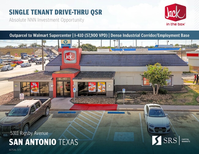
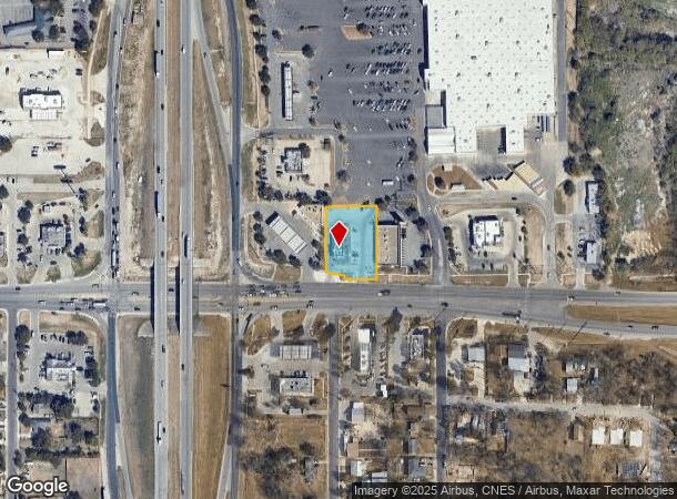
5311 Us Highway 87 E
San Antonio-New Braunfels, TX
Rigsby Road Subd
12887-000-0142
NCB 12887 BLK LOT 14 (RIGSBY ROAD SUBD)
Restaurantdrivein
Bexar
X
Texas
48029C0420G
142
2024
0.77 AC
2025
South
131402
San Antonio
3,019 SF
DEMOGRAPHICS near 5311 Us Highway 87 E
1 Mile
3 Mile
5 Mile
2024 Total Population
7,106
53,789
156,611
2029 Population
7,554
57,869
167,878
Pop Growth 2024-2029
+ 6.30%
+ 7.59%
+ 7.19%
Average Age
39
36
36
2024 Total Households
2,468
18,270
53,510
HH Growth 2024-2029
+ 6.36%
+ 7.75%
+ 7.30%
Median Household Inc
$54,526
$44,304
$43,950
Avg Household Size
2.80
2.80
2.80
2024 Avg HH Vehicles
2.00
2.00
2.00
Median Home Value
$162,727
$156,694
$151,017
Median Year Built
1969
1978
1974
Nearby Places
Map Layers
Map Styles
 Street
 Aerial
- Restaurants
- Banks
- Shops
- Fitness
- Groceries
PUBLIC TRANSPORTATION
COMMUTER RAIL
San Antonio Amtrak Station (Sunset Limited - Amtrak, Texas Eagle - Amtrak)
DRIVE
WALK
Distance
San Antonio Amtrak Station (Sunset Limited - Amtrak, Texas Eagle - Amtrak)
13 min
7.4 mi
AIRPORT
San Antonio International
DRIVE
WALK
Distance
San Antonio International
19 min
14.8 mi
Freight Ports
Calhoun Port
DRIVE
WALK
Distance
Calhoun Port
167 min
139.1 mi
Nearby Properties
Address
Land Use
TOTAL SIZE
Lot Size
Zoning
Address
Land Use
TOTAL SIZE
Lot Size
Zoning
545,980 SF
125.36 AC
Address
Land Use
TOTAL SIZE
Lot Size
Zoning
122,130 SF
541.40 AC
Address
Land Use
TOTAL SIZE
Lot Size
Zoning
434,029 SF
109.87 AC
Address
Land Use
TOTAL SIZE
Lot Size
Zoning
397,806 SF
15.08 AC
Address
Land Use
TOTAL SIZE
Lot Size
Zoning
690,500 SF
16.96 AC
Address
Land Use
TOTAL SIZE
Lot Size
Zoning
359,459 SF
15.81 AC
Address
Land Use
TOTAL SIZE
Lot Size
Zoning
380,949 SF
146.39 AC
Address
Land Use
TOTAL SIZE
Lot Size
Zoning
380,949 SF
135.47 AC
Address
Land Use
TOTAL SIZE
Lot Size
Zoning
Address
Land Use
TOTAL SIZE
Lot Size
Zoning
35.76 AC
Address
Land Use
TOTAL SIZE
Lot Size
Zoning
273,370 SF
11.93 AC
Address
Land Use
TOTAL SIZE
Lot Size
Zoning
42.04 AC
Address
Land Use
TOTAL SIZE
Lot Size
Zoning
41.63 AC
Address
Land Use
TOTAL SIZE
Lot Size
Zoning
33.77 AC
Address
Land Use
TOTAL SIZE
Lot Size
Zoning
4,920 SF
860.60 AC
Address
Land Use
TOTAL SIZE
Lot Size
Zoning
101,517 SF
13.04 AC
Address
Land Use
TOTAL SIZE
Lot Size
Zoning
18.35 AC
Address
Land Use
TOTAL SIZE
Lot Size
Zoning
17.47 AC
Address
Land Use
TOTAL SIZE
Lot Size
Zoning
95,486 SF
12.54 AC
Address
Land Use
TOTAL SIZE
Lot Size
Zoning
332,148 SF
17.75 AC
Address
Land Use
TOTAL SIZE
Lot Size
Zoning
68,055 SF
18.06 AC
Address
Land Use
TOTAL SIZE
Lot Size
Zoning
141,955 SF
121.60 AC
Address
Land Use
TOTAL SIZE
Lot Size
Zoning
1,859 SF
60.40 AC
Address
Land Use
TOTAL SIZE
Lot Size
Zoning
201,672 SF
12.48 AC
Address
Land Use
TOTAL SIZE
Lot Size
Zoning
296,542 SF
26.32 AC
Address
Land Use
TOTAL SIZE
Lot Size
Zoning
44,800 SF
61.44 AC
Address
Land Use
TOTAL SIZE
Lot Size
Zoning
64,043 SF
14.96 AC
Address
Land Use
TOTAL SIZE
Lot Size
Zoning
143,012 SF
9.35 AC
Address
Land Use
TOTAL SIZE
Lot Size
Zoning
233,361 SF
9.65 AC
Address
Land Use
TOTAL SIZE
Lot Size
Zoning
3,131 SF
291.90 AC
The World's #1 Commercial Real Estate Marketplace
Connect with us
© 2025 CoStar Group
The information above has been obtained from sources believed reliable. While we do not doubt its accuracy we have not verified it and make no guarantee, warranty or representation about it. It is your responsibility to independently confirm its accuracy and completeness. Any projections, opinions, assumptions, or estimates used are for example only and do not represent the current or future performance of the property. The value of this transaction to you depends on tax and other factors which should be evaluated by your tax, financial, and legal advisors. You and your advisors should conduct a careful, independent investigation of the property to determine to your satisfaction the suitability of the property for your needs.