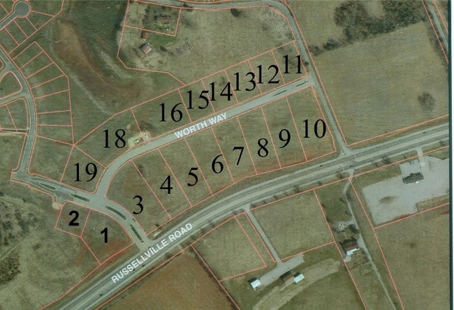
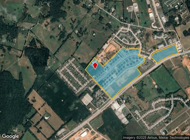
Property Record
Russellville Rd, Bowling Green, KY 42101
NEARBY LISTINGS FOR SALE OR LEASE
Property Detail
Russellville Rd
029B-06
Hillview Mills
Residentialacreage
Warren
X
Kentucky
21141C0225D
45.17 AC
2025
Bowling Green Area
2025
Other Market Areas
010200
Bowling Green, KY
DEMOGRAPHICS near Russellville Rd
1 Mile
3 Mile
5 Mile
2024 Total Population
2,223
29,291
77,770
2029 Population
2,464
32,217
85,192
Pop Growth 2024-2029
+ 10.84%
+ 9.99%
+ 9.54%
Average Age
38
34
35
2024 Total Households
866
11,164
28,982
HH Growth 2024-2029
+ 11.32%
+ 10.18%
+ 10.16%
Median Household Inc
$69,793
$59,622
$52,032
Avg Household Size
2.50
2.50
2.40
2024 Avg HH Vehicles
2.00
2.00
2.00
Median Home Value
$212,937
$196,737
$220,167
Median Year Built
1999
1997
1991
Nearby Places
- Restaurants
- Banks
- Shops
- Fitness
- Groceries
Nearby Properties
Address
Land Use
TOTAL SIZE
Lot Size
Zoning
Address
Land Use
TOTAL SIZE
Lot Size
Zoning
1,421,383 SF
97.81 AC
Address
Land Use
TOTAL SIZE
Lot Size
Zoning
884,032 SF
42.74 AC
Address
Land Use
TOTAL SIZE
Lot Size
Zoning
462,286 SF
62.54 AC
Address
Land Use
TOTAL SIZE
Lot Size
Zoning
16.99 AC
Address
Land Use
TOTAL SIZE
Lot Size
Zoning
304,620 SF
38.65 AC
Address
Land Use
TOTAL SIZE
Lot Size
Zoning
64,770 SF
21.31 AC
Address
Land Use
TOTAL SIZE
Lot Size
Zoning
260,800 SF
16.76 AC
Address
Land Use
TOTAL SIZE
Lot Size
Zoning
49,434 SF
43.95 AC
Address
Land Use
TOTAL SIZE
Lot Size
Zoning
Address
Land Use
TOTAL SIZE
Lot Size
Zoning
418,117 SF
44.30 AC
Address
Land Use
TOTAL SIZE
Lot Size
Zoning
302,295 SF
21.14 AC
Address
Land Use
TOTAL SIZE
Lot Size
Zoning
Address
Land Use
TOTAL SIZE
Lot Size
Zoning
2,946 SF
3.59 AC
Address
Land Use
TOTAL SIZE
Lot Size
Zoning
82,675 SF
5.02 AC
Address
Land Use
TOTAL SIZE
Lot Size
Zoning
245,000 SF
80.51 AC
Address
Land Use
TOTAL SIZE
Lot Size
Zoning
283,545 SF
38.28 AC
Address
Land Use
TOTAL SIZE
Lot Size
Zoning
1,800 SF
81.73 AC
Address
Land Use
TOTAL SIZE
Lot Size
Zoning
26,632 SF
63.57 AC
Address
Land Use
TOTAL SIZE
Lot Size
Zoning
245,774 SF
39.12 AC
Address
Land Use
TOTAL SIZE
Lot Size
Zoning
241,486 SF
23.20 AC
Address
Land Use
TOTAL SIZE
Lot Size
Zoning
225,400 SF
30.34 AC
Address
Land Use
TOTAL SIZE
Lot Size
Zoning
273,829 SF
6.29 AC
Address
Land Use
TOTAL SIZE
Lot Size
Zoning
168,353 SF
37.76 AC
Address
Land Use
TOTAL SIZE
Lot Size
Zoning
15,450 SF
11.78 AC
Address
Land Use
TOTAL SIZE
Lot Size
Zoning
Address
Land Use
TOTAL SIZE
Lot Size
Zoning
4,055 SF
3.11 AC
Address
Land Use
TOTAL SIZE
Lot Size
Zoning
43,663 SF
8.77 AC
Address
Land Use
TOTAL SIZE
Lot Size
Zoning
11,568 SF
2.30 AC
Address
Land Use
TOTAL SIZE
Lot Size
Zoning
17,280 SF
8.89 AC
Address
Land Use
TOTAL SIZE
Lot Size
Zoning
171,464 SF
25.11 AC
The World's #1 Commercial Real Estate Marketplace
Connect with us
© 2025 CoStar Group
The information above has been obtained from sources believed reliable. While we do not doubt its accuracy we have not verified it and make no guarantee, warranty or representation about it. It is your responsibility to independently confirm its accuracy and completeness. Any projections, opinions, assumptions, or estimates used are for example only and do not represent the current or future performance of the property. The value of this transaction to you depends on tax and other factors which should be evaluated by your tax, financial, and legal advisors. You and your advisors should conduct a careful, independent investigation of the property to determine to your satisfaction the suitability of the property for your needs.