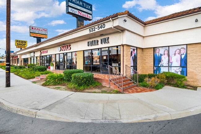
Property Record
530 N Azusa Ave, Covina, CA 91722
Current Lease Availabilities
NEARBY LISTINGS FOR SALE OR LEASE
Property Detail
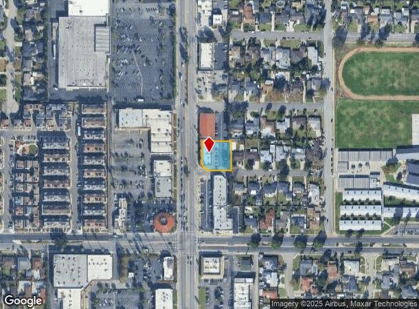
530 N Azusa Ave
Los Angeles-Long Beach-Glendale, CA
Parcel Map No 19312
8443-018-018
P M 206-73-74 LOT 1
Storemultistory
Los Angeles
X
California
06037C1700F
1
2024
0.43 AC
2025
Eastern SGV
406000
Los Angeles
7,540 SF
DEMOGRAPHICS near 530 N Azusa Ave
1 Mile
3 Mile
5 Mile
2024 Total Population
24,195
184,617
459,954
2029 Population
23,301
177,683
442,808
Pop Growth 2024-2029
(3.69%)
(3.76%)
(3.73%)
Average Age
40
40
40
2024 Total Households
7,615
54,431
131,627
HH Growth 2024-2029
(3.98%)
(4.02%)
(3.97%)
Median Household Inc
$81,726
$85,935
$86,948
Avg Household Size
3.10
3.30
3.40
2024 Avg HH Vehicles
2.00
2.00
2.00
Median Home Value
$719,934
$695,836
$682,750
Median Year Built
1958
1958
1963
Nearby Places
Map Layers
Map Styles
 Street
 Aerial
- Restaurants
- Banks
- Shops
- Fitness
- Groceries
PUBLIC TRANSPORTATION
COMMUTER RAIL
Covina (San Bernardino Line - Southern California Regional Rail Authority (Metrolink))
DRIVE
WALK
Distance
Covina (San Bernardino Line - Southern California Regional Rail Authority (Metrolink))
4 min
1.9 mi
Baldwin Park (San Bernardino Line - Southern California Regional Rail Authority (Metrolink))
DRIVE
WALK
Distance
Baldwin Park (San Bernardino Line - Southern California Regional Rail Authority (Metrolink))
6 min
3.3 mi
AIRPORT
Ontario International
DRIVE
WALK
Distance
Ontario International
31 min
21.9 mi
Long Beach (Daugherty Field)
DRIVE
WALK
Distance
Long Beach (Daugherty Field)
39 min
29.5 mi
Bob Hope
DRIVE
WALK
Distance
Bob Hope
45 min
33.9 mi
Nearby Properties
Address
Land Use
TOTAL SIZE
Lot Size
Zoning
Address
Land Use
TOTAL SIZE
Lot Size
Zoning
702,934 SF
16.81 AC
WCCR
Address
Land Use
TOTAL SIZE
Lot Size
Zoning
546,676 SF
6.38 AC
WCCR*
Address
Land Use
TOTAL SIZE
Lot Size
Zoning
286,646 SF
21.99 AC
WCOPCC*
Address
Land Use
TOTAL SIZE
Lot Size
Zoning
83,337 SF
38.49 AC
WCCR*
Address
Land Use
TOTAL SIZE
Lot Size
Zoning
190,824 SF
8.21 AC
WCR3-MF20*
Address
Land Use
TOTAL SIZE
Lot Size
Zoning
1,104,998 SF
28 AC
IRM2*
Address
Land Use
TOTAL SIZE
Lot Size
Zoning
748,778 SF
11.48 AC
CVC3A*
Address
Land Use
TOTAL SIZE
Lot Size
Zoning
184,820 SF
IRM1*
Address
Land Use
TOTAL SIZE
Lot Size
Zoning
862,213 SF
21.22 AC
WCSP
Address
Land Use
TOTAL SIZE
Lot Size
Zoning
627,908 SF
23.08 AC
IRM1*
Address
Land Use
TOTAL SIZE
Lot Size
Zoning
119,669 SF
1.56 AC
WCCR*
Address
Land Use
TOTAL SIZE
Lot Size
Zoning
63,919 SF
2.97 AC
CVCP*
Address
Land Use
TOTAL SIZE
Lot Size
Zoning
154,820 SF
3.68 AC
WCRA
Address
Land Use
TOTAL SIZE
Lot Size
Zoning
459,461 SF
1.40 AC
WCCR*
Address
Land Use
TOTAL SIZE
Lot Size
Zoning
163,848 SF
9.16 AC
WCPCD1*
Address
Land Use
TOTAL SIZE
Lot Size
Zoning
294,391 SF
16.90 AC
WCC5*
Address
Land Use
TOTAL SIZE
Lot Size
Zoning
73,908 SF
7.70 AC
IRM1*
Address
Land Use
TOTAL SIZE
Lot Size
Zoning
108,544 SF
6.24 AC
LCC4*
Address
Land Use
TOTAL SIZE
Lot Size
Zoning
104,253 SF
2.88 AC
CVRD2000*
Address
Land Use
TOTAL SIZE
Lot Size
Zoning
120,588 SF
4.50 AC
WCR3-MF20*
Address
Land Use
TOTAL SIZE
Lot Size
Zoning
184,800 SF
4.73 AC
CVTCP*
Address
Land Use
TOTAL SIZE
Lot Size
Zoning
105,936 SF
5.24 AC
WCR3-MF20*
Address
Land Use
TOTAL SIZE
Lot Size
Zoning
90,786 SF
1.66 AC
CVE5 & PCD
Address
Land Use
TOTAL SIZE
Lot Size
Zoning
195,586 SF
2.58 AC
WCCR*
Address
Land Use
TOTAL SIZE
Lot Size
Zoning
213,749 SF
4.99 AC
IRM2
Address
Land Use
TOTAL SIZE
Lot Size
Zoning
109,333 SF
4.30 AC
WCR3-MF20*
Address
Land Use
TOTAL SIZE
Lot Size
Zoning
315,543 SF
9.03 AC
WCNC*
Address
Land Use
TOTAL SIZE
Lot Size
Zoning
155,907 SF
4.38 AC
CVR3-RD150
Address
Land Use
TOTAL SIZE
Lot Size
Zoning
163,472 SF
8.40 AC
WCR3-MF20*
Address
Land Use
TOTAL SIZE
Lot Size
Zoning
147,852 SF
5.29 AC
AZM2YY
The World's #1 Commercial Real Estate Marketplace
Connect with us
© 2025 CoStar Group
The information above has been obtained from sources believed reliable. While we do not doubt its accuracy we have not verified it and make no guarantee, warranty or representation about it. It is your responsibility to independently confirm its accuracy and completeness. Any projections, opinions, assumptions, or estimates used are for example only and do not represent the current or future performance of the property. The value of this transaction to you depends on tax and other factors which should be evaluated by your tax, financial, and legal advisors. You and your advisors should conduct a careful, independent investigation of the property to determine to your satisfaction the suitability of the property for your needs.