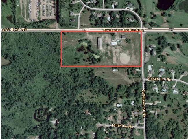
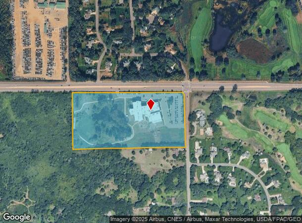
Property Record
532 Bunker Lake Blvd Ne, Andover, MN 55304
NEARBY LISTINGS FOR SALE OR LEASE
Property Detail
532 Bunker Lake Blvd Ne
31-32-23-31-0001
THAT PRT OF NE1/4 OF SW1/4 OF SEC 31 TWP 32 RGE 23 DESC AS FOL. COM AT NE COR OF SD 1/4 1/4, TH W ALG N LINE OF SD 1/4 1/4, 1
Taxexempt
Anoka
A
Minnesota
27053C0100F
18 AC
2025
Anoka County Outlying
2025
Minneapolis/St Paul
050215
Minneapolis-St. Paul-Bloomington, MN-WI
104,477 SF
DEMOGRAPHICS near 532 Bunker Lake Blvd Ne
1 Mile
3 Mile
5 Mile
2024 Total Population
3,040
50,947
136,847
2029 Population
3,157
52,894
142,146
Pop Growth 2024-2029
+ 3.85%
+ 3.82%
+ 3.87%
Average Age
43
39
39
2024 Total Households
1,108
17,681
48,778
HH Growth 2024-2029
+ 3.79%
+ 3.78%
+ 3.84%
Median Household Inc
$117,584
$107,259
$97,328
Avg Household Size
2.70
2.80
2.70
2024 Avg HH Vehicles
2.00
2.00
2.00
Median Home Value
$357,683
$317,903
$304,832
Median Year Built
1994
1991
1990
Nearby Places
Map Layers
Map Styles
 Street
 Aerial
- Restaurants
- Banks
- Shops
- Fitness
- Groceries
PUBLIC TRANSPORTATION
COMMUTER RAIL
Coon Rapids-Riverdale Station (Northstar Corridor - Northstar Commuter Rail)
DRIVE
WALK
Distance
Coon Rapids-Riverdale Station (Northstar Corridor - Northstar Commuter Rail)
13 min
6.9 mi
Anoka Station (Northstar Corridor - Northstar Commuter Rail)
DRIVE
WALK
Distance
Anoka Station (Northstar Corridor - Northstar Commuter Rail)
15 min
7.6 mi
AIRPORT
Minneapolis-St Paul International/Wold-Chamberlain
DRIVE
WALK
Distance
Minneapolis-St Paul International/Wold-Chamberlain
45 min
30.5 mi
Freight Ports
Port Milwaukee
DRIVE
WALK
Distance
Port Milwaukee
391 min
352.7 mi
Nearby Properties
Address
Land Use
TOTAL SIZE
Lot Size
Zoning
Address
Land Use
TOTAL SIZE
Lot Size
Zoning
1,075 SF
41.99 AC
Address
Land Use
TOTAL SIZE
Lot Size
Zoning
225,576 SF
6.07 AC
Address
Land Use
TOTAL SIZE
Lot Size
Zoning
179,853 SF
37.73 AC
Address
Land Use
TOTAL SIZE
Lot Size
Zoning
192 SF
11.30 AC
Address
Land Use
TOTAL SIZE
Lot Size
Zoning
133,906 SF
34.37 AC
Address
Land Use
TOTAL SIZE
Lot Size
Zoning
7,888 SF
40 AC
Address
Land Use
TOTAL SIZE
Lot Size
Zoning
76,383 SF
7.60 AC
Address
Land Use
TOTAL SIZE
Lot Size
Zoning
98,642 SF
20.01 AC
Address
Land Use
TOTAL SIZE
Lot Size
Zoning
135,994 SF
3.20 AC
Address
Land Use
TOTAL SIZE
Lot Size
Zoning
162,450 SF
9.97 AC
Address
Land Use
TOTAL SIZE
Lot Size
Zoning
83,688 SF
5.75 AC
Address
Land Use
TOTAL SIZE
Lot Size
Zoning
8,410 SF
12.69 AC
Address
Land Use
TOTAL SIZE
Lot Size
Zoning
124,951 SF
12.67 AC
Address
Land Use
TOTAL SIZE
Lot Size
Zoning
152,040 SF
20.71 AC
Address
Land Use
TOTAL SIZE
Lot Size
Zoning
76,374 SF
4.91 AC
Address
Land Use
TOTAL SIZE
Lot Size
Zoning
156,889 SF
18.95 AC
Address
Land Use
TOTAL SIZE
Lot Size
Zoning
10,912 SF
1.97 AC
Address
Land Use
TOTAL SIZE
Lot Size
Zoning
8,680 SF
8.12 AC
Address
Land Use
TOTAL SIZE
Lot Size
Zoning
139,229 SF
13 AC
Address
Land Use
TOTAL SIZE
Lot Size
Zoning
71,144 SF
5.43 AC
Address
Land Use
TOTAL SIZE
Lot Size
Zoning
69,978 SF
16.48 AC
Address
Land Use
TOTAL SIZE
Lot Size
Zoning
Address
Land Use
TOTAL SIZE
Lot Size
Zoning
70,304 SF
Address
Land Use
TOTAL SIZE
Lot Size
Zoning
Address
Land Use
TOTAL SIZE
Lot Size
Zoning
Address
Land Use
TOTAL SIZE
Lot Size
Zoning
6,080 SF
20 AC
Address
Land Use
TOTAL SIZE
Lot Size
Zoning
26,719 SF
36.48 AC
Address
Land Use
TOTAL SIZE
Lot Size
Zoning
62,369 SF
15 AC
The World's #1 Commercial Real Estate Marketplace
Connect with us
© 2026 CoStar Group
The information above has been obtained from sources believed reliable. While we do not doubt its accuracy we have not verified it and make no guarantee, warranty or representation about it. It is your responsibility to independently confirm its accuracy and completeness. Any projections, opinions, assumptions, or estimates used are for example only and do not represent the current or future performance of the property. The value of this transaction to you depends on tax and other factors which should be evaluated by your tax, financial, and legal advisors. You and your advisors should conduct a careful, independent investigation of the property to determine to your satisfaction the suitability of the property for your needs.