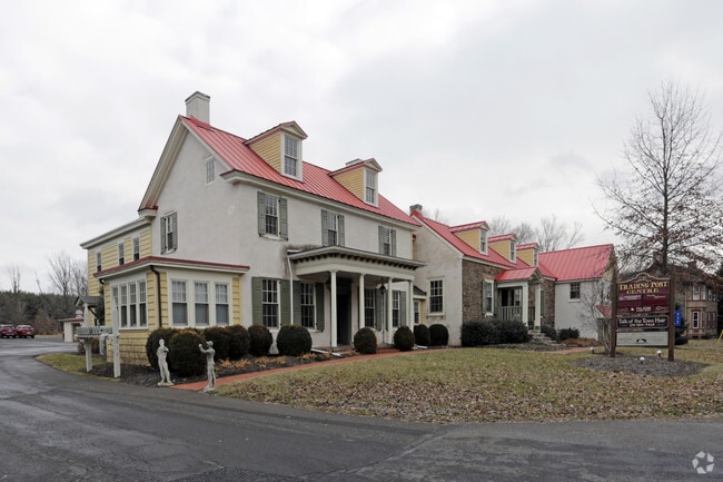
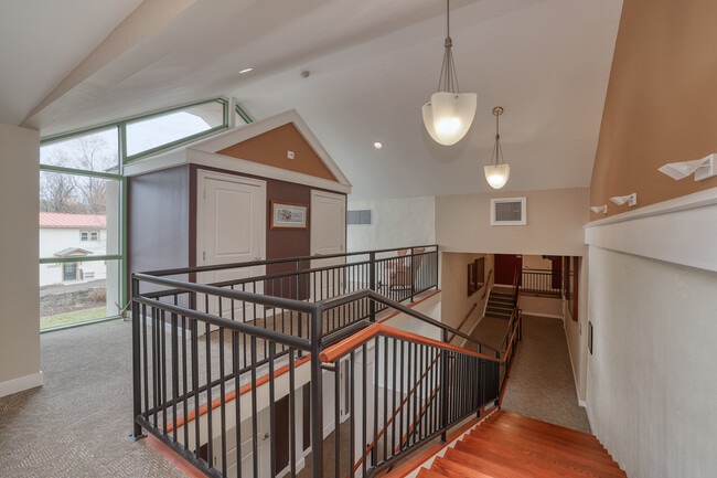
Property Record
532 Durham Rd, Langhorne, PA 19047

NEARBY LISTINGS FOR SALE OR LEASE
Property Detail
532 Durham Rd
53-012-067
1.5A LOT E S DOYLESTOWN R D 1372 FT S T369 DURHAM RD 532
Officebuilding
Bucks
X
Pennsylvania
42017C0338J
e
2024
1.50 AC
2025
Lower Bucks County
106000
Philadelphia
9,488 SF
Philadelphia-Camden-Wilmington, PA-NJ-DE-MD
DEMOGRAPHICS near 532 Durham Rd
1 Mile
3 Mile
5 Mile
2024 Total Population
1,636
15,592
63,740
2029 Population
1,597
15,408
63,283
Pop Growth 2024-2029
(2.38%)
(1.18%)
(0.72%)
Average Age
42
44
45
2024 Total Households
552
5,577
23,574
HH Growth 2024-2029
(2.54%)
(1.24%)
(0.82%)
Median Household Inc
$163,809
$151,981
$139,552
Avg Household Size
2.90
2.80
2.60
2024 Avg HH Vehicles
2.00
2.00
2.00
Median Home Value
$690,000
$633,409
$546,469
Median Year Built
1984
1987
1984
Nearby Places
Map Layers
Map Styles
 Street
 Aerial
- Restaurants
- Banks
- Shops
- Fitness
- Groceries
SALE & LEASE HISTORY
LISTING DATE
SALE/LEASE

Sep 25, 2016
For Lease
Mar 08, 2023
For Sale
Jun 19, 2020
For Lease
Jun 09, 2022
For Lease
Nearby Properties
Address
Land Use
TOTAL SIZE
Lot Size
Zoning
Address
Land Use
TOTAL SIZE
Lot Size
Zoning
170,342 SF
28.26 AC
PC
Address
Land Use
TOTAL SIZE
Lot Size
Zoning
113,929 SF
10.43 AC
VRI
Address
Land Use
TOTAL SIZE
Lot Size
Zoning
48,948 SF
4.48 AC
VRI
Address
Land Use
TOTAL SIZE
Lot Size
Zoning
800 SF
147.62 AC
QA
Address
Land Use
TOTAL SIZE
Lot Size
Zoning
53,644 SF
8.91 AC
R1
Address
Land Use
TOTAL SIZE
Lot Size
Zoning
19,410 SF
7.53 AC
IP
Address
Land Use
TOTAL SIZE
Lot Size
Zoning
42,588 SF
42.73 AC
AG
Address
Land Use
TOTAL SIZE
Lot Size
Zoning
22,023 SF
5.70 AC
VC2
Address
Land Use
TOTAL SIZE
Lot Size
Zoning
Address
Land Use
TOTAL SIZE
Lot Size
Zoning
18,480 SF
34.34 AC
CM
Address
Land Use
TOTAL SIZE
Lot Size
Zoning
43.44 AC
CM
Address
Land Use
TOTAL SIZE
Lot Size
Zoning
4,300 SF
38.79 AC
CM
Address
Land Use
TOTAL SIZE
Lot Size
Zoning
0.33 AC
CM
Address
Land Use
TOTAL SIZE
Lot Size
Zoning
55,750 SF
4.06 AC
R1
Address
Land Use
TOTAL SIZE
Lot Size
Zoning
6,849 SF
8.46 AC
CM
Address
Land Use
TOTAL SIZE
Lot Size
Zoning
9,944 SF
2.82 AC
VC2
Address
Land Use
TOTAL SIZE
Lot Size
Zoning
6.95 AC
CR1
Address
Land Use
TOTAL SIZE
Lot Size
Zoning
14,515 SF
1.12 AC
MS
Address
Land Use
TOTAL SIZE
Lot Size
Zoning
34,126 SF
47.69 AC
VR1
Address
Land Use
TOTAL SIZE
Lot Size
Zoning
44,574 SF
9.87 AC
CR1
Address
Land Use
TOTAL SIZE
Lot Size
Zoning
58.62 AC
R2
Address
Land Use
TOTAL SIZE
Lot Size
Zoning
7,988 SF
1.55 AC
R2
Address
Land Use
TOTAL SIZE
Lot Size
Zoning
23,590 SF
8.24 AC
VC1
Address
Land Use
TOTAL SIZE
Lot Size
Zoning
2,012 SF
48.73 AC
QA
Address
Land Use
TOTAL SIZE
Lot Size
Zoning
2,508 SF
1.16 AC
PS
Address
Land Use
TOTAL SIZE
Lot Size
Zoning
5,743 SF
0.64 AC
VR1
Address
Land Use
TOTAL SIZE
Lot Size
Zoning
3,682 SF
33.60 AC
CM
Address
Land Use
TOTAL SIZE
Lot Size
Zoning
28,728 SF
49.41 AC
AG
Address
Land Use
TOTAL SIZE
Lot Size
Zoning
27,287 SF
1.22 AC
VC2
The World's #1 Commercial Real Estate Marketplace
Connect with us
© 2026 CoStar Group
The information above has been obtained from sources believed reliable. While we do not doubt its accuracy we have not verified it and make no guarantee, warranty or representation about it. It is your responsibility to independently confirm its accuracy and completeness. Any projections, opinions, assumptions, or estimates used are for example only and do not represent the current or future performance of the property. The value of this transaction to you depends on tax and other factors which should be evaluated by your tax, financial, and legal advisors. You and your advisors should conduct a careful, independent investigation of the property to determine to your satisfaction the suitability of the property for your needs.