Property Record
532 E Emaus St, Middletown, PA 17057

Save to a Folder
{{folder.Name}}
{{folder.ListingIds.length}} Properties
{{folder.ListingIds.length}} Property
Create a New Folder
Current Lease Availabilities
Property Detail
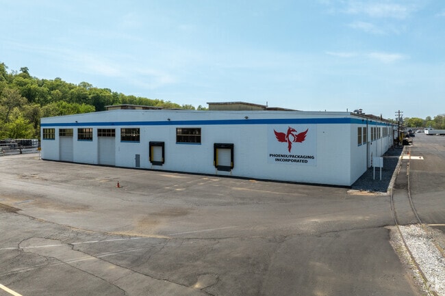
532 E Emaus St
41-022-003
Dauphin
Warehouse
Pennsylvania
AE The base floodplain where base flood elevations are provided. AE Zones are now used on new format FIRMs instead of A1-A30 Zones.
27 AC
2026
Harrisburg Area East
2026
Philadelphia
023800
Harrisburg-Carlisle, PA
928 SF
NEARBY LISTINGS FOR SALE OR LEASE
DEMOGRAPHICS near 532 E Emaus St
1 mile
3 mile
5 mile
2025 Total Population
9,144
20,630
53,335
2030 Population
9,335
21,028
54,340
Pop Growth 2025-2030
+ 2.09%
+ 1.93%
+ 1.88%
Average Age
39
40
41
2025 Total Households
4,039
8,277
21,269
HH Growth 2025-2030
+ 2.20%
+ 2.05%
+ 1.97%
Median Household Inc
$54,829
$68,501
$84,011
Avg Household Size
2.20
2.30
2.40
2025 Avg HH Vehicles
2.00
2.00
2.00
Median Home Value
$157,696
$193,142
$251,518
Median Year Built
1957
1970
1977
Nearby Places
Map Layers
Map Styles
 Street
 Aerial
Layers
 Traffic
 Biking
Places
Listings with unknown addresses are not visible on the map
- Restaurants
- Banks
- Shops
- Fitness
- Groceries
Nearby Properties
Address
Land Use
TOTAL SIZE
Lot Size
Zoning
Address
Land Use
TOTAL SIZE
Lot Size
Zoning
5,737 SF
592.08 AC
Address
Land Use
TOTAL SIZE
Lot Size
Zoning
185,784 SF
173.81 AC
Address
Land Use
TOTAL SIZE
Lot Size
Zoning
196.27 AC
Address
Land Use
TOTAL SIZE
Lot Size
Zoning
72,186 SF
117.31 AC
Address
Land Use
TOTAL SIZE
Lot Size
Zoning
240,000 SF
68.73 AC
Address
Land Use
TOTAL SIZE
Lot Size
Zoning
29,440 SF
82.92 AC
Address
Land Use
TOTAL SIZE
Lot Size
Zoning
3,029 SF
54.26 AC
Address
Land Use
TOTAL SIZE
Lot Size
Zoning
142,010 SF
53.46 AC
Address
Land Use
TOTAL SIZE
Lot Size
Zoning
5,396 SF
49.35 AC
Address
Land Use
TOTAL SIZE
Lot Size
Zoning
26,700 SF
185.86 AC
Address
Land Use
TOTAL SIZE
Lot Size
Zoning
651,250 SF
47.13 AC
Address
Land Use
TOTAL SIZE
Lot Size
Zoning
139,528 SF
32.10 AC
Address
Land Use
TOTAL SIZE
Lot Size
Zoning
1,196 SF
50.34 AC
Address
Land Use
TOTAL SIZE
Lot Size
Zoning
Address
Land Use
TOTAL SIZE
Lot Size
Zoning
2,400 SF
9.11 AC
Address
Land Use
TOTAL SIZE
Lot Size
Zoning
320,000 SF
16.71 AC
Address
Land Use
TOTAL SIZE
Lot Size
Zoning
40,000 SF
48.30 AC
Address
Land Use
TOTAL SIZE
Lot Size
Zoning
249,112 SF
24.01 AC
Address
Land Use
TOTAL SIZE
Lot Size
Zoning
59,760 SF
61.67 AC
Address
Land Use
TOTAL SIZE
Lot Size
Zoning
119,325 SF
19.72 AC
Address
Land Use
TOTAL SIZE
Lot Size
Zoning
3,737 SF
97.13 AC
Address
Land Use
TOTAL SIZE
Lot Size
Zoning
186,000 SF
10.58 AC
Address
Land Use
TOTAL SIZE
Lot Size
Zoning
37,224 SF
12.57 AC
Address
Land Use
TOTAL SIZE
Lot Size
Zoning
214,400 SF
14.74 AC
Address
Land Use
TOTAL SIZE
Lot Size
Zoning
41,462 SF
13.95 AC
Address
Land Use
TOTAL SIZE
Lot Size
Zoning
68,285 SF
2.77 AC
Address
Land Use
TOTAL SIZE
Lot Size
Zoning
15,094 SF
3.90 AC
Address
Land Use
TOTAL SIZE
Lot Size
Zoning
2,224 SF
7.34 AC
Address
Land Use
TOTAL SIZE
Lot Size
Zoning
125,718 SF
20.32 AC
Address
Land Use
TOTAL SIZE
Lot Size
Zoning
52,600 SF
9.85 AC
The World's #1 Commercial Real Estate Marketplace
Connect with us
© 2026 CoStar Group
The information above has been obtained from sources believed reliable. While we do not doubt its accuracy we have not verified it and make no guarantee, warranty or representation about it. It is your responsibility to independently confirm its accuracy and completeness. Any projections, opinions, assumptions, or estimates used are for example only and do not represent the current or future performance of the property. The value of this transaction to you depends on tax and other factors which should be evaluated by your tax, financial, and legal advisors. You and your advisors should conduct a careful, independent investigation of the property to determine to your satisfaction the suitability of the property for your needs.