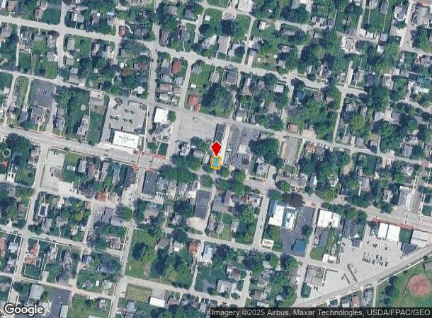
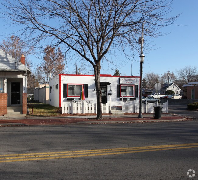
Property Record
532 Main St, Groveport, OH 43125

NEARBY LISTINGS FOR SALE OR LEASE
Property Detail
532 Main St
Columbus, OH
Rareys Port
185-000115
MAIN ST 50FT S E OF E 1/2 OUT LOT 33
Foodprocessing
Franklin
X
Ohio
39129C0075J
33
2024
0.04 AC
2024
Southeast
009440
Columbus
680 SF
DEMOGRAPHICS near 532 Main St
1 Mile
3 Mile
5 Mile
2024 Total Population
3,704
14,454
82,009
2029 Population
3,692
14,512
82,403
Pop Growth 2024-2029
(0.32%)
+ 0.40%
+ 0.48%
Average Age
42
41
38
2024 Total Households
1,585
5,832
31,605
HH Growth 2024-2029
(0.32%)
+ 0.27%
+ 0.38%
Median Household Inc
$73,387
$77,418
$61,795
Avg Household Size
2.30
2.40
2.50
2024 Avg HH Vehicles
2.00
2.00
2.00
Median Home Value
$204,167
$209,005
$180,777
Median Year Built
1973
1990
1989
Nearby Places
Map Layers
Map Styles
 Street
 Aerial
- Restaurants
- Banks
- Shops
- Fitness
- Groceries
PUBLIC TRANSPORTATION
AIRPORT
Rickenbacker International
DRIVE
WALK
Distance
Rickenbacker International
10 min
4.7 mi
John Glenn Columbus International
DRIVE
WALK
Distance
John Glenn Columbus International
22 min
13.5 mi
Freight Ports
Port of Toledo
DRIVE
WALK
Distance
Port of Toledo
201 min
161.7 mi
Nearby Properties
Address
Land Use
TOTAL SIZE
Lot Size
Zoning
Address
Land Use
TOTAL SIZE
Lot Size
Zoning
4,200 SF
852.55 AC
Address
Land Use
TOTAL SIZE
Lot Size
Zoning
471,215 SF
49.74 AC
Address
Land Use
TOTAL SIZE
Lot Size
Zoning
1,466,512 SF
49.72 AC
Address
Land Use
TOTAL SIZE
Lot Size
Zoning
1,219,000 SF
59.32 AC
Address
Land Use
TOTAL SIZE
Lot Size
Zoning
1,021,020 SF
68.44 AC
Address
Land Use
TOTAL SIZE
Lot Size
Zoning
977,584 SF
70.14 AC
Address
Land Use
TOTAL SIZE
Lot Size
Zoning
1,280,501 SF
69.60 AC
Address
Land Use
TOTAL SIZE
Lot Size
Zoning
959,688 SF
55.34 AC
Address
Land Use
TOTAL SIZE
Lot Size
Zoning
778,272 SF
42.31 AC
Address
Land Use
TOTAL SIZE
Lot Size
Zoning
903,780 SF
45.43 AC
Address
Land Use
TOTAL SIZE
Lot Size
Zoning
720,200 SF
35.71 AC
Address
Land Use
TOTAL SIZE
Lot Size
Zoning
785,854 SF
30.85 AC
Address
Land Use
TOTAL SIZE
Lot Size
Zoning
553,548 SF
46.23 AC
Address
Land Use
TOTAL SIZE
Lot Size
Zoning
541,910 SF
36.84 AC
Address
Land Use
TOTAL SIZE
Lot Size
Zoning
639,600 SF
43.91 AC
Address
Land Use
TOTAL SIZE
Lot Size
Zoning
743,315 SF
42.17 AC
Address
Land Use
TOTAL SIZE
Lot Size
Zoning
567,000 SF
23.08 AC
Address
Land Use
TOTAL SIZE
Lot Size
Zoning
68,492 SF
23.63 AC
Address
Land Use
TOTAL SIZE
Lot Size
Zoning
250,174 SF
178.12 AC
Address
Land Use
TOTAL SIZE
Lot Size
Zoning
528,750 SF
42.14 AC
Address
Land Use
TOTAL SIZE
Lot Size
Zoning
754,000 SF
41.60 AC
Address
Land Use
TOTAL SIZE
Lot Size
Zoning
224,090 SF
66.22 AC
Address
Land Use
TOTAL SIZE
Lot Size
Zoning
632,000 SF
35.98 AC
Address
Land Use
TOTAL SIZE
Lot Size
Zoning
668,447 SF
41.68 AC
Address
Land Use
TOTAL SIZE
Lot Size
Zoning
478,544 SF
23.04 AC
Address
Land Use
TOTAL SIZE
Lot Size
Zoning
478,544 SF
24.25 AC
Address
Land Use
TOTAL SIZE
Lot Size
Zoning
713,440 SF
40.94 AC
Address
Land Use
TOTAL SIZE
Lot Size
Zoning
483,620 SF
28.80 AC
Address
Land Use
TOTAL SIZE
Lot Size
Zoning
446,160 SF
91.12 AC
Address
Land Use
TOTAL SIZE
Lot Size
Zoning
446,160 SF
22.71 AC
The World's #1 Commercial Real Estate Marketplace
Connect with us
© 2025 CoStar Group
The information above has been obtained from sources believed reliable. While we do not doubt its accuracy we have not verified it and make no guarantee, warranty or representation about it. It is your responsibility to independently confirm its accuracy and completeness. Any projections, opinions, assumptions, or estimates used are for example only and do not represent the current or future performance of the property. The value of this transaction to you depends on tax and other factors which should be evaluated by your tax, financial, and legal advisors. You and your advisors should conduct a careful, independent investigation of the property to determine to your satisfaction the suitability of the property for your needs.