Property Record
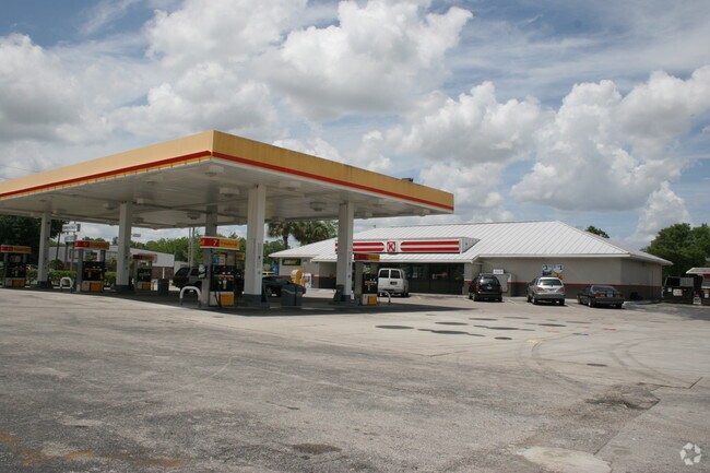
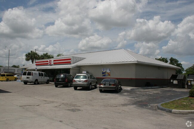
532 Old Dixie Hwy E, Auburndale, FL 33823


Property Detail
532 Old Dixie Hwy E
24-28-13-000000-012020
BEG SE COR OF SE1/4 OF NE1/4 RUN N 290.30 FT W 25 FT FOR POB CONT W 215.92 FT S 185.88 FT TO NLY R/W LINE US 92 RUN E 11.99 FT N 18 FT E 116.63 FT RUN ELY 48.91 FT ALONG CURVE RUN N 30 DEG 41 MIN 10 SEC E 18.40 FT N 52 FT E 28.79 FT N 99.90 FT TO POB
Servicestation
POLK
C3
Florida
B and X Area of moderate flood hazard, usually the area between the limits of the 100-year and 500-year floods.
1.30 AC
2024
Polk County
2025
Tampa/St Petersburg
011604
Lakeland-Winter Haven, FL
4,677 SF
NEARBY LISTINGS FOR SALE OR LEASE
DEMOGRAPHICS near 532 Old Dixie Hwy E
1 mile
3 mile
5 mile
2025 Total Population
3,523
22,660
64,516
2030 Population
4,052
25,950
73,537
Pop Growth 2025-2030
+ 15.02%
+ 14.52%
+ 13.98%
Average Age
47
42
40
2025 Total Households
1,516
9,076
24,673
HH Growth 2025-2030
+ 15.30%
+ 14.93%
+ 14.33%
Median Household Inc
$59,423
$54,528
$58,198
Avg Household Size
2.30
2.40
2.50
2025 Avg HH Vehicles
2.00
2.00
2.00
Median Home Value
$106,228
$128,060
$191,854
Median Year Built
1992
1985
1981
Nearby Places
Map Layers
Map Styles
 Street
 Aerial
Layers
 Traffic
 Biking
Places
Listings with unknown addresses are not visible on the map
- Restaurants
- Banks
- Shops
- Fitness
- Groceries
PUBLIC TRANSPORTATION
COMMUTER RAIL
Drive
Walk
Distance
11 min
6.0 mi
Freight Ports
Port of Tampa Bay
Drive
Walk
Distance
Port of Tampa Bay
56 min
40.0 mi
Nearby Properties
Address
Land Use
TOTAL SIZE
Lot Size
Zoning
Address
Land Use
TOTAL SIZE
Lot Size
Zoning
831,600 SF
51.22 AC
Address
Land Use
TOTAL SIZE
Lot Size
Zoning
811,392 SF
47.70 AC
Address
Land Use
TOTAL SIZE
Lot Size
Zoning
275,220 SF
94.53 AC
Address
Land Use
TOTAL SIZE
Lot Size
Zoning
188,553 SF
29.12 AC
Address
Land Use
TOTAL SIZE
Lot Size
Zoning
84,129 SF
336.67 AC
Address
Land Use
TOTAL SIZE
Lot Size
Zoning
135,247 SF
22.49 AC
C4
Address
Land Use
TOTAL SIZE
Lot Size
Zoning
72,853 SF
6.78 AC
C3
Address
Land Use
TOTAL SIZE
Lot Size
Zoning
126,384 SF
4.67 AC
CH
Address
Land Use
TOTAL SIZE
Lot Size
Zoning
100,000 SF
58.51 AC
RE2
Address
Land Use
TOTAL SIZE
Lot Size
Zoning
147,180 SF
11.44 AC
C4
Address
Land Use
TOTAL SIZE
Lot Size
Zoning
117,592 SF
10.02 AC
GI
Address
Land Use
TOTAL SIZE
Lot Size
Zoning
80,280 SF
25.05 AC
Address
Land Use
TOTAL SIZE
Lot Size
Zoning
79,856 SF
14.14 AC
Address
Land Use
TOTAL SIZE
Lot Size
Zoning
77,279 SF
12.12 AC
Address
Land Use
TOTAL SIZE
Lot Size
Zoning
113,410 SF
19.78 AC
C4
Address
Land Use
TOTAL SIZE
Lot Size
Zoning
Address
Land Use
TOTAL SIZE
Lot Size
Zoning
66,000 SF
8.33 AC
Address
Land Use
TOTAL SIZE
Lot Size
Zoning
80,160 SF
2.79 AC
C4
Address
Land Use
TOTAL SIZE
Lot Size
Zoning
30,898 SF
7.27 AC
Address
Land Use
TOTAL SIZE
Lot Size
Zoning
54,204 SF
9.09 AC
Address
Land Use
TOTAL SIZE
Lot Size
Zoning
70,370 SF
4.86 AC
GI
Address
Land Use
TOTAL SIZE
Lot Size
Zoning
17,688 SF
3.16 AC
C3
Address
Land Use
TOTAL SIZE
Lot Size
Zoning
53,000 SF
5.15 AC
GI
Address
Land Use
TOTAL SIZE
Lot Size
Zoning
51,059 SF
14.36 AC
XX
Address
Land Use
TOTAL SIZE
Lot Size
Zoning
178,950 SF
23.99 AC
PUD
Address
Land Use
TOTAL SIZE
Lot Size
Zoning
35,397 SF
1.90 AC
Address
Land Use
TOTAL SIZE
Lot Size
Zoning
91,080 SF
10.22 AC
GI
Address
Land Use
TOTAL SIZE
Lot Size
Zoning
6,032 SF
2.26 AC
Address
Land Use
TOTAL SIZE
Lot Size
Zoning
62,020 SF
21.99 AC
Address
Land Use
TOTAL SIZE
Lot Size
Zoning
17,760 SF
2.62 AC
The World's #1 Commercial Real Estate Marketplace
Connect with us
© 2026 CoStar Group
The information above has been obtained from sources believed reliable. While we do not doubt its accuracy we have not verified it and make no guarantee, warranty or representation about it. It is your responsibility to independently confirm its accuracy and completeness. Any projections, opinions, assumptions, or estimates used are for example only and do not represent the current or future performance of the property. The value of this transaction to you depends on tax and other factors which should be evaluated by your tax, financial, and legal advisors. You and your advisors should conduct a careful, independent investigation of the property to determine to your satisfaction the suitability of the property for your needs.