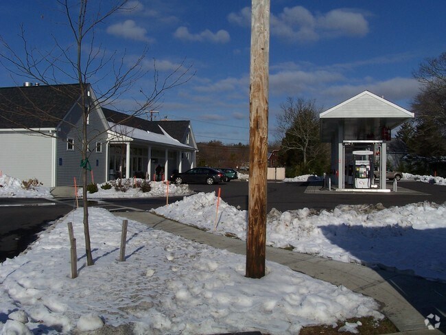
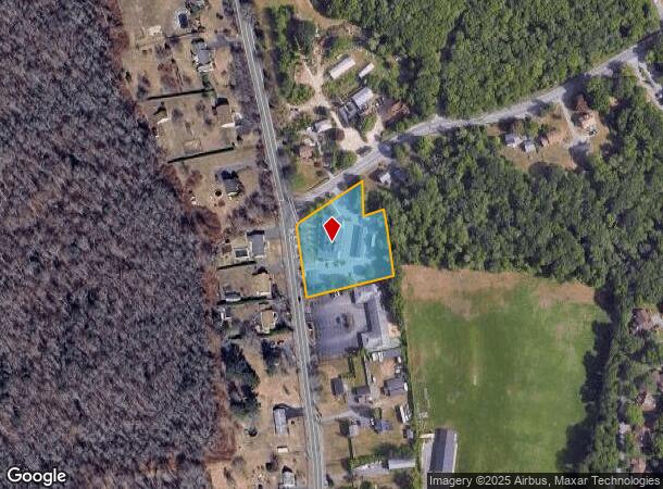
Property Record
532 Russells Mills Rd, South Dartmouth, MA 02748
NEARBY LISTINGS FOR SALE OR LEASE
-
-
-
-
No Photo
-
View all South Dartmouth listings for sale on LoopNet.com
Property Detail
532 Russells Mills Rd
Storebuilding
Bristol
X
Massachusetts
25005C0476G
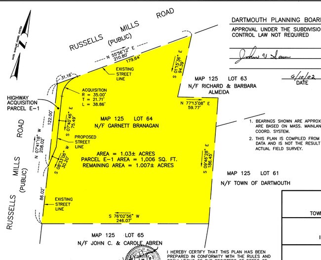
1.01 AC
2025
Attleboro/New Bedford
2025
Boston
653301
Providence-Warwick, RI-MA
5,507 SF
DART-000125-000064
DEMOGRAPHICS near 532 Russells Mills Rd
1 Mile
3 Mile
5 Mile
2024 Total Population
2,664
28,615
93,359
2029 Population
2,671
28,345
91,689
Pop Growth 2024-2029
+ 0.26%
(0.94%)
(1.79%)
Average Age
47
44
41
2024 Total Households
1,055
11,327
37,863
HH Growth 2024-2029
+ 0.28%
(0.90%)
(1.84%)
Median Household Inc
$121,749
$81,882
$56,781
Avg Household Size
2.50
2.40
2.30
2024 Avg HH Vehicles
2.00
2.00
2.00
Median Home Value
$508,314
$394,615
$365,664
Median Year Built
1978
1958
1949
Nearby Places
- Restaurants
- Banks
- Shops
- Fitness
- Groceries
PUBLIC TRANSPORTATION
AIRPORT
Rhode Island Tf Green International
DRIVE
WALK
Distance
Rhode Island Tf Green International
57 min
37.7 mi
Freight Ports
Port of New Bedford Harbor
DRIVE
WALK
Distance
Port of New Bedford Harbor
12 min
4.9 mi
Nearby Properties
Address
Land Use
TOTAL SIZE
Lot Size
Zoning
Address
Land Use
TOTAL SIZE
Lot Size
Zoning
10.29 AC
RA
Address
Land Use
TOTAL SIZE
Lot Size
Zoning
120,000 SF
705.15 AC
SRB
Address
Land Use
TOTAL SIZE
Lot Size
Zoning
265,000 SF
39.70 AC
SRB
Address
Land Use
TOTAL SIZE
Lot Size
Zoning
74.70 AC
SRA
Address
Land Use
TOTAL SIZE
Lot Size
Zoning
Address
Land Use
TOTAL SIZE
Lot Size
Zoning
5,716 SF
35.18 AC
GR
Address
Land Use
TOTAL SIZE
Lot Size
Zoning
126,745 SF
15.82 AC
GB
Address
Land Use
TOTAL SIZE
Lot Size
Zoning
130,060 SF
18.34 AC
SRA
Address
Land Use
TOTAL SIZE
Lot Size
Zoning
48.78 AC
RA
Address
Land Use
TOTAL SIZE
Lot Size
Zoning
9.51 AC
SRA
Address
Land Use
TOTAL SIZE
Lot Size
Zoning
30.17 AC
RB
Address
Land Use
TOTAL SIZE
Lot Size
Zoning
38.29 AC
RB
Address
Land Use
TOTAL SIZE
Lot Size
Zoning
158,678 SF
3.11 AC
MUB
Address
Land Use
TOTAL SIZE
Lot Size
Zoning
76,014 SF
5.09 AC
GB
Address
Land Use
TOTAL SIZE
Lot Size
Zoning
83,357 SF
8.60 AC
GB
Address
Land Use
TOTAL SIZE
Lot Size
Zoning
79,972 SF
4.47 AC
RC
Address
Land Use
TOTAL SIZE
Lot Size
Zoning
25.37 AC
RA
Address
Land Use
TOTAL SIZE
Lot Size
Zoning
77,537 SF
4.07 AC
RC
Address
Land Use
TOTAL SIZE
Lot Size
Zoning
66,771 SF
7.51 AC
GB
Address
Land Use
TOTAL SIZE
Lot Size
Zoning
3.27 AC
GR
Address
Land Use
TOTAL SIZE
Lot Size
Zoning
14.91 AC
SRA
Address
Land Use
TOTAL SIZE
Lot Size
Zoning
73,868 SF
8.42 AC
IB
Address
Land Use
TOTAL SIZE
Lot Size
Zoning
50,182 SF
50.79 AC
GR
Address
Land Use
TOTAL SIZE
Lot Size
Zoning
70,824 SF
8.70 AC
MUB
Address
Land Use
TOTAL SIZE
Lot Size
Zoning
79,408 SF
0.99 AC
IB
Address
Land Use
TOTAL SIZE
Lot Size
Zoning
26,010 SF
6.80 AC
GB
Address
Land Use
TOTAL SIZE
Lot Size
Zoning
760 SF
11.74 AC
RA
Address
Land Use
TOTAL SIZE
Lot Size
Zoning
27,052 SF
5.58 AC
RB
Address
Land Use
TOTAL SIZE
Lot Size
Zoning
45,573 SF
0.98 AC
RA
Address
Land Use
TOTAL SIZE
Lot Size
Zoning
47,956 SF
3.50 AC
GB
The World's #1 Commercial Real Estate Marketplace
Connect with us
© 2025 CoStar Group
The information above has been obtained from sources believed reliable. While we do not doubt its accuracy we have not verified it and make no guarantee, warranty or representation about it. It is your responsibility to independently confirm its accuracy and completeness. Any projections, opinions, assumptions, or estimates used are for example only and do not represent the current or future performance of the property. The value of this transaction to you depends on tax and other factors which should be evaluated by your tax, financial, and legal advisors. You and your advisors should conduct a careful, independent investigation of the property to determine to your satisfaction the suitability of the property for your needs.