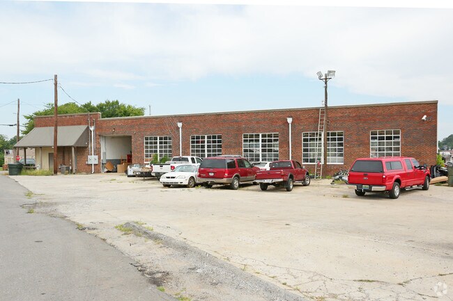
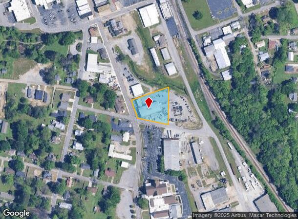
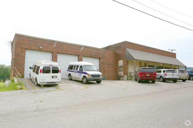
Property Record
532 Sparkman St Sw, Hartselle, AL 35640
NEARBY LISTINGS FOR SALE OR LEASE
Property Detail
532 Sparkman St Sw
15-05-15-1-001-004.000
Hartselle
Publicstorage
PT NE1/4 NE1/4 BEG INT E LN & N ROW ROGERS ST TH N 245'S ON E LN TH SW 265'S TO E ROW SPARKMAN ST SW TH SE 120'S ON E ROW TO
AE
Morgan
01103C0208F
Alabama
2025
1.41 AC
2024
Alabama North Area
005303
Other Market Areas
10,217 SF
Decatur, AL
DEMOGRAPHICS near 532 Sparkman St Sw
1 Mile
3 Mile
5 Mile
2024 Total Population
4,789
17,039
22,788
2029 Population
4,830
17,143
22,959
Pop Growth 2024-2029
+ 0.86%
+ 0.61%
+ 0.75%
Average Age
41
40
41
2024 Total Households
2,017
6,772
9,006
HH Growth 2024-2029
+ 0.89%
+ 0.63%
+ 0.76%
Median Household Inc
$48,577
$65,884
$67,432
Avg Household Size
2.30
2.50
2.50
2024 Avg HH Vehicles
2.00
2.00
2.00
Median Home Value
$171,514
$178,001
$184,752
Median Year Built
1977
1982
1984
Nearby Places
Map Layers
Map Styles
 Street
 Aerial
- Restaurants
- Banks
- Shops
- Fitness
- Groceries
PUBLIC TRANSPORTATION
AIRPORT
Huntsville International-Carl T Jones Field
DRIVE
WALK
Distance
Huntsville International-Carl T Jones Field
34 min
25.0 mi
Freight Ports
Port of Mobile
DRIVE
WALK
Distance
Port of Mobile
355 min
323.8 mi
Nearby Properties
Address
Land Use
TOTAL SIZE
Lot Size
Zoning
Address
Land Use
TOTAL SIZE
Lot Size
Zoning
79,148 SF
2.34 AC
Address
Land Use
TOTAL SIZE
Lot Size
Zoning
28,978 SF
6.50 AC
Address
Land Use
TOTAL SIZE
Lot Size
Zoning
155,504 SF
19 AC
Address
Land Use
TOTAL SIZE
Lot Size
Zoning
135,937 SF
27 AC
Address
Land Use
TOTAL SIZE
Lot Size
Zoning
115,286 SF
23 AC
Address
Land Use
TOTAL SIZE
Lot Size
Zoning
12,057 SF
2 AC
Address
Land Use
TOTAL SIZE
Lot Size
Zoning
12,973 SF
1.05 AC
Address
Land Use
TOTAL SIZE
Lot Size
Zoning
25,468 SF
2.70 AC
Address
Land Use
TOTAL SIZE
Lot Size
Zoning
70,400 SF
7.60 AC
Address
Land Use
TOTAL SIZE
Lot Size
Zoning
5,074 SF
11 AC
Address
Land Use
TOTAL SIZE
Lot Size
Zoning
1,848 SF
4.80 AC
Address
Land Use
TOTAL SIZE
Lot Size
Zoning
282,610 SF
44 AC
Address
Land Use
TOTAL SIZE
Lot Size
Zoning
36,240 SF
10 AC
Address
Land Use
TOTAL SIZE
Lot Size
Zoning
16,204 SF
1.58 AC
Address
Land Use
TOTAL SIZE
Lot Size
Zoning
39,184 SF
1.80 AC
Address
Land Use
TOTAL SIZE
Lot Size
Zoning
3,690 SF
5 AC
Address
Land Use
TOTAL SIZE
Lot Size
Zoning
73,090 SF
5.45 AC
Address
Land Use
TOTAL SIZE
Lot Size
Zoning
17,640 SF
1.90 AC
Address
Land Use
TOTAL SIZE
Lot Size
Zoning
16,650 SF
0.92 AC
Address
Land Use
TOTAL SIZE
Lot Size
Zoning
875 SF
2 AC
Address
Land Use
TOTAL SIZE
Lot Size
Zoning
32,987 SF
1.20 AC
Address
Land Use
TOTAL SIZE
Lot Size
Zoning
10,677 SF
4 AC
Address
Land Use
TOTAL SIZE
Lot Size
Zoning
1,042 SF
3.90 AC
Address
Land Use
TOTAL SIZE
Lot Size
Zoning
14,850 SF
1.48 AC
Address
Land Use
TOTAL SIZE
Lot Size
Zoning
27,026 SF
1.80 AC
Address
Land Use
TOTAL SIZE
Lot Size
Zoning
9,879 SF
5.30 AC
Address
Land Use
TOTAL SIZE
Lot Size
Zoning
50.20 AC
ARMH1
Address
Land Use
TOTAL SIZE
Lot Size
Zoning
120,000 SF
19.30 AC
Address
Land Use
TOTAL SIZE
Lot Size
Zoning
6,808 SF
5 AC
Address
Land Use
TOTAL SIZE
Lot Size
Zoning
13,342 SF
4.70 AC
The World's #1 Commercial Real Estate Marketplace
Connect with us
© 2025 CoStar Group
The information above has been obtained from sources believed reliable. While we do not doubt its accuracy we have not verified it and make no guarantee, warranty or representation about it. It is your responsibility to independently confirm its accuracy and completeness. Any projections, opinions, assumptions, or estimates used are for example only and do not represent the current or future performance of the property. The value of this transaction to you depends on tax and other factors which should be evaluated by your tax, financial, and legal advisors. You and your advisors should conduct a careful, independent investigation of the property to determine to your satisfaction the suitability of the property for your needs.