Property Record
5320 College Blvd, Leawood, KS 66211
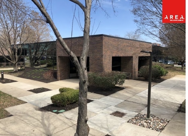
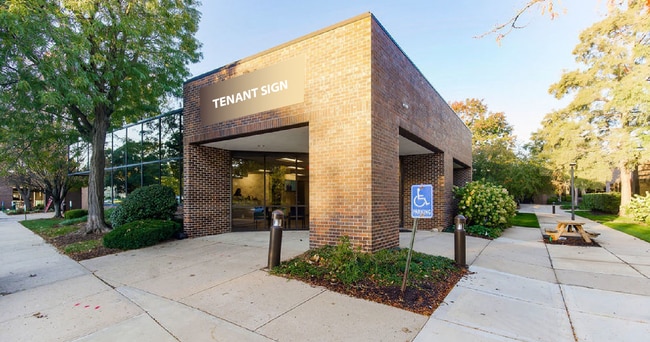
This Property Is For Sale
NEARBY LISTINGS FOR SALE OR LEASE
Property Detail
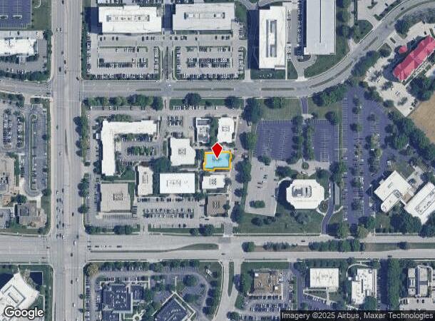
5320 College Blvd
NF251309-2053
9-13-25 SE CR SW1/4 W 1923.30N 55 TO N/L 111TH ST W 60 N 45 NE 33.81 N 200.19 W 135.21 N 10 TO PT OF BG N 21 NE 5.66 & 1 N 45 E 65 NW 1 NE 5.66 E 41 S 21 SW 5.66 & 1 S 45 W 65 S 1 SW5.66 W 41 TO BG TR C .1708 ACS M/L OPC 358 25C
Officebuilding
Johnson
X
Kansas
20091C0069G
0.17 AC
2024
College Blvd
2024
Kansas City
053201
Kansas City, MO-KS
6,329 SF
DEMOGRAPHICS near 5320 College Blvd
1 Mile
3 Mile
5 Mile
2024 Total Population
7,625
81,790
235,002
2029 Population
8,272
85,101
242,988
Pop Growth 2024-2029
+ 8.49%
+ 4.05%
+ 3.40%
Average Age
45
44
42
2024 Total Households
3,842
36,231
102,822
HH Growth 2024-2029
+ 8.59%
+ 4.28%
+ 3.49%
Median Household Inc
$96,694
$91,873
$88,050
Avg Household Size
1.80
2.20
2.20
2024 Avg HH Vehicles
2.00
2.00
2.00
Median Home Value
$454,641
$385,944
$338,781
Median Year Built
2001
1982
1980
Nearby Places
- Restaurants
- Banks
- Shops
- Fitness
- Groceries
PUBLIC TRANSPORTATION
AIRPORT
Kansas City International
DRIVE
WALK
Distance
Kansas City International
47 min
36.1 mi
Nearby Properties
Address
Land Use
TOTAL SIZE
Lot Size
Zoning
Address
Land Use
TOTAL SIZE
Lot Size
Zoning
364,818 SF
25.48 AC
R-1
Address
Land Use
TOTAL SIZE
Lot Size
Zoning
47.39 AC
AG
Address
Land Use
TOTAL SIZE
Lot Size
Zoning
177,588 SF
9.27 AC
CP-O
Address
Land Use
TOTAL SIZE
Lot Size
Zoning
189,882 SF
13.04 AC
CP-O
Address
Land Use
TOTAL SIZE
Lot Size
Zoning
316,432 SF
29.39 AC
R-1
Address
Land Use
TOTAL SIZE
Lot Size
Zoning
3,426,762 SF
183.73 AC
CP-O
Address
Land Use
TOTAL SIZE
Lot Size
Zoning
122,309 SF
76.14 AC
R-1
Address
Land Use
TOTAL SIZE
Lot Size
Zoning
305,147 SF
49.02 AC
R-1
Address
Land Use
TOTAL SIZE
Lot Size
Zoning
335,643 SF
25.13 AC
R-1
Address
Land Use
TOTAL SIZE
Lot Size
Zoning
325,588 SF
36.63 AC
SD-CR
Address
Land Use
TOTAL SIZE
Lot Size
Zoning
79,917 SF
7.86 AC
SD-NCR
Address
Land Use
TOTAL SIZE
Lot Size
Zoning
120,305 SF
7.01 AC
CP-O
Address
Land Use
TOTAL SIZE
Lot Size
Zoning
259,257 SF
24.74 AC
CP-O
Address
Land Use
TOTAL SIZE
Lot Size
Zoning
96,100 SF
25.01 AC
R-1
Address
Land Use
TOTAL SIZE
Lot Size
Zoning
81,051 SF
7.17 AC
R-1
Address
Land Use
TOTAL SIZE
Lot Size
Zoning
110,710 SF
4.66 AC
CP-O
Address
Land Use
TOTAL SIZE
Lot Size
Zoning
59,570 SF
8.46 AC
SD-O
Address
Land Use
TOTAL SIZE
Lot Size
Zoning
113,263 SF
3.53 AC
CP-O
Address
Land Use
TOTAL SIZE
Lot Size
Zoning
73,383 SF
9.53 AC
R-1
Address
Land Use
TOTAL SIZE
Lot Size
Zoning
166,097 SF
37.29 AC
R-1
Address
Land Use
TOTAL SIZE
Lot Size
Zoning
105,110 SF
8.93 AC
AG
Address
Land Use
TOTAL SIZE
Lot Size
Zoning
69,958 SF
10.93 AC
R-1
Address
Land Use
TOTAL SIZE
Lot Size
Zoning
436,499 SF
22.71 AC
Address
Land Use
TOTAL SIZE
Lot Size
Zoning
355,197 SF
30.05 AC
CP-2
Address
Land Use
TOTAL SIZE
Lot Size
Zoning
179,965 SF
6.15 AC
CP-O
Address
Land Use
TOTAL SIZE
Lot Size
Zoning
863,831 SF
31.21 AC
BP
Address
Land Use
TOTAL SIZE
Lot Size
Zoning
120,225 SF
9.13 AC
R-1
Address
Land Use
TOTAL SIZE
Lot Size
Zoning
119,320 SF
19.74 AC
R-1
Address
Land Use
TOTAL SIZE
Lot Size
Zoning
66,083 SF
14.91 AC
R-1
Address
Land Use
TOTAL SIZE
Lot Size
Zoning
77,548 SF
7.21 AC
R-1
The World's #1 Commercial Real Estate Marketplace
Connect with us
© 2025 CoStar Group
The information above has been obtained from sources believed reliable. While we do not doubt its accuracy we have not verified it and make no guarantee, warranty or representation about it. It is your responsibility to independently confirm its accuracy and completeness. Any projections, opinions, assumptions, or estimates used are for example only and do not represent the current or future performance of the property. The value of this transaction to you depends on tax and other factors which should be evaluated by your tax, financial, and legal advisors. You and your advisors should conduct a careful, independent investigation of the property to determine to your satisfaction the suitability of the property for your needs.