Property Record
5321 W Novak Way, Laveen, AZ 85339
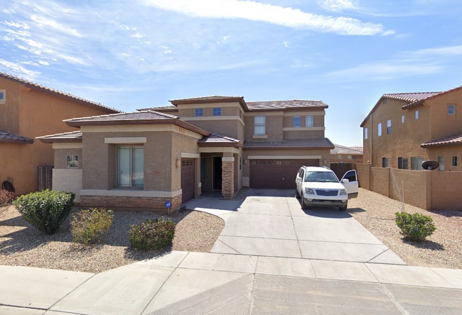
This Property Is For Sale
NEARBY LISTINGS FOR SALE OR LEASE
-
-
View all Laveen listings for sale on LoopNet.com
Property Detail
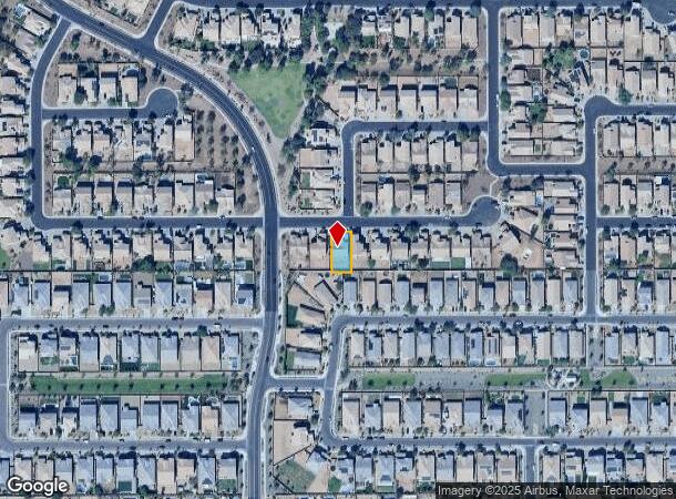
5321 W Novak Way
Phoenix-Mesa-Scottsdale, AZ
Sierra Colina
104-79-084
Maricopa
Sfr
Arizona
X
0.17 AC
04013C2195L
Southwest Phoenix
2,852 SF
Phoenix
DEMOGRAPHICS near 5321 W Novak Way
1 Mile
3 Mile
5 Mile
2024 Total Population
12,940
76,313
150,726
2029 Population
13,409
79,886
157,630
Pop Growth 2024-2029
+ 3.62%
+ 4.68%
+ 4.58%
Average Age
33
34
34
2024 Total Households
3,487
20,709
40,957
HH Growth 2024-2029
+ 3.58%
+ 4.80%
+ 4.76%
Median Household Inc
$113,892
$99,500
$89,233
Avg Household Size
3.60
3.50
3.50
2024 Avg HH Vehicles
2.00
2.00
2.00
Median Home Value
$439,877
$437,700
$410,645
Median Year Built
2006
2005
2004
Nearby Places
- Restaurants
- Banks
- Shops
- Fitness
- Groceries
PUBLIC TRANSPORTATION
AIRPORT
Phoenix Sky Harbor International
DRIVE
WALK
Distance
Phoenix Sky Harbor International
26 min
13.8 mi
Phoenix-Mesa Gateway
DRIVE
WALK
Distance
Phoenix-Mesa Gateway
49 min
37.8 mi
Freight Ports
Port of San Diego
DRIVE
WALK
Distance
Port of San Diego
395 min
354.3 mi
Nearby Properties
Address
Land Use
TOTAL SIZE
Lot Size
Zoning
Address
Land Use
TOTAL SIZE
Lot Size
Zoning
68,452 SF
37.95 AC
R-35
Address
Land Use
TOTAL SIZE
Lot Size
Zoning
60.41 AC
CPGCP
Address
Land Use
TOTAL SIZE
Lot Size
Zoning
86,350 SF
25.82 AC
I-1
Address
Land Use
TOTAL SIZE
Lot Size
Zoning
33.15 AC
Address
Land Use
TOTAL SIZE
Lot Size
Zoning
20,430 SF
24.57 AC
I-1
Address
Land Use
TOTAL SIZE
Lot Size
Zoning
61,508 SF
23.76 AC
I-1
Address
Land Use
TOTAL SIZE
Lot Size
Zoning
392,945 SF
47.26 AC
R-43AG
Address
Land Use
TOTAL SIZE
Lot Size
Zoning
367,953 SF
38.18 AC
R-43AG
Address
Land Use
TOTAL SIZE
Lot Size
Zoning
270,483 SF
53.58 AC
R-43AG
Address
Land Use
TOTAL SIZE
Lot Size
Zoning
554,581 SF
37.82 AC
A1
Address
Land Use
TOTAL SIZE
Lot Size
Zoning
489,284 SF
28.64 AC
I-1
Address
Land Use
TOTAL SIZE
Lot Size
Zoning
474,532 SF
26.17 AC
I-1
Address
Land Use
TOTAL SIZE
Lot Size
Zoning
347,565 SF
21.44 AC
A1
Address
Land Use
TOTAL SIZE
Lot Size
Zoning
603,910 SF
30.70 AC
I-1
Address
Land Use
TOTAL SIZE
Lot Size
Zoning
258,720 SF
46.57 AC
A-1
Address
Land Use
TOTAL SIZE
Lot Size
Zoning
1,135,308 SF
93.77 AC
I-1
Address
Land Use
TOTAL SIZE
Lot Size
Zoning
335,440 SF
21.67 AC
Address
Land Use
TOTAL SIZE
Lot Size
Zoning
489,022 SF
25.15 AC
I-1
Address
Land Use
TOTAL SIZE
Lot Size
Zoning
1,875 SF
7.89 AC
I-1
Address
Land Use
TOTAL SIZE
Lot Size
Zoning
70,951 SF
336.40 AC
R-43AG
Address
Land Use
TOTAL SIZE
Lot Size
Zoning
233,156 SF
15.77 AC
R3A
Address
Land Use
TOTAL SIZE
Lot Size
Zoning
273,812 SF
32.75 AC
I-1
Address
Land Use
TOTAL SIZE
Lot Size
Zoning
93,310 SF
9.16 AC
R-6
Address
Land Use
TOTAL SIZE
Lot Size
Zoning
103,253 SF
13.22 AC
R-43AG
Address
Land Use
TOTAL SIZE
Lot Size
Zoning
250,356 SF
13.59 AC
A2
Address
Land Use
TOTAL SIZE
Lot Size
Zoning
95,854 SF
15.11 AC
R-43AG
Address
Land Use
TOTAL SIZE
Lot Size
Zoning
317,458 SF
18.70 AC
I-1
Address
Land Use
TOTAL SIZE
Lot Size
Zoning
313,600 SF
19.70 AC
I-1
Address
Land Use
TOTAL SIZE
Lot Size
Zoning
329,055 SF
18.89 AC
I-1
Address
Land Use
TOTAL SIZE
Lot Size
Zoning
90,115 SF
18.29 AC
R-43AG
The World's #1 Commercial Real Estate Marketplace
Connect with us
© 2025 CoStar Group
The information above has been obtained from sources believed reliable. While we do not doubt its accuracy we have not verified it and make no guarantee, warranty or representation about it. It is your responsibility to independently confirm its accuracy and completeness. Any projections, opinions, assumptions, or estimates used are for example only and do not represent the current or future performance of the property. The value of this transaction to you depends on tax and other factors which should be evaluated by your tax, financial, and legal advisors. You and your advisors should conduct a careful, independent investigation of the property to determine to your satisfaction the suitability of the property for your needs.