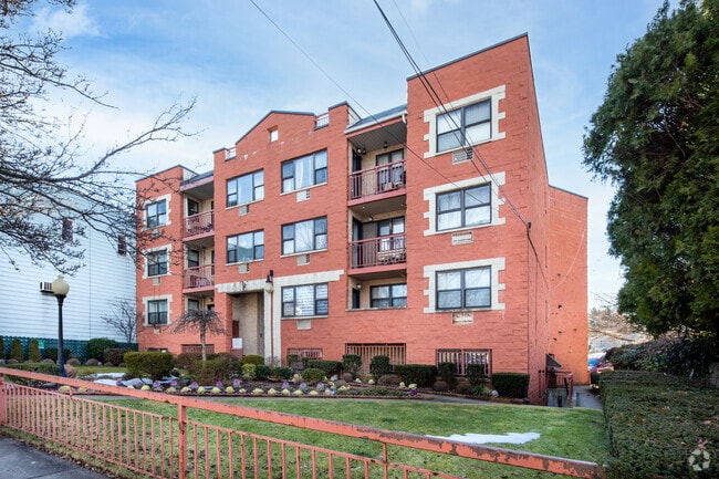
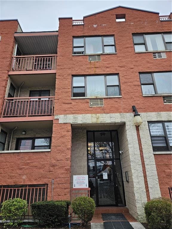
Property Record
5324 Metropolitan Ave, Ridgewood, NY 11385
NEARBY LISTINGS FOR SALE OR LEASE
Property Detail
5324 Metropolitan Ave
03361-1007
Grandview Condos
Officebuilding
Queens
X
New York
3604970208F
1007
2024
0.20 AC
2025
Ridgewood
059501
Long Island (New York)
894 SF
New York-Jersey City-White Plains, NY-NJ
DEMOGRAPHICS near 5324 Metropolitan Ave
1 Mile
3 Mile
5 Mile
2024 Total Population
85,825
1,034,401
3,077,496
2029 Population
79,058
973,680
2,884,961
Pop Growth 2024-2029
(7.88%)
(5.87%)
(6.26%)
Average Age
37
38
39
2024 Total Households
30,670
385,557
1,252,992
HH Growth 2024-2029
(8.48%)
(6.17%)
(6.48%)
Median Household Inc
$73,225
$72,105
$80,743
Avg Household Size
2.70
2.60
2.30
2024 Avg HH Vehicles
1.00
1.00
.00
Median Home Value
$797,963
$792,172
$809,790
Median Year Built
1947
1949
1950
Nearby Places
Map Layers
Map Styles
 Street
 Aerial
- Restaurants
- Banks
- Shops
- Fitness
- Groceries
PUBLIC TRANSPORTATION
TRANSIT/SUBWAY
Jefferson Street (L - New York MTA Subway (The Subway))
DRIVE
WALK
Distance
Jefferson Street (L - New York MTA Subway (The Subway))
3 min
16 min
0.8 mi
DeKalb Avenue (L Line) (L - New York MTA Subway (The Subway))
DRIVE
WALK
Distance
DeKalb Avenue (L Line) (L - New York MTA Subway (The Subway))
3 min
16 min
0.8 mi
Forest Avenue (M - New York MTA Subway (The Subway))
DRIVE
WALK
Distance
Forest Avenue (M - New York MTA Subway (The Subway))
3 min
16 min
0.8 mi
Seneca Avenue (M - New York MTA Subway (The Subway))
DRIVE
WALK
Distance
Seneca Avenue (M - New York MTA Subway (The Subway))
4 min
19 min
1.0 mi
COMMUTER RAIL
Woodside Station (Babylon Branch - Long Island Rail Road, Far Rockaway Branch - Long Island Rail Road, Hempstead Branch - Long Island Rail Road, Long Beach Branch - Long Island Rail Road, Montauk Branch - Long Island Rail Road, Port Jefferson Branch - Long Island Rail Road, Port Washington Branch - Long Island Rail Road, Ronkonkoma Branch - Long Island Rail Road)
DRIVE
WALK
Distance
Woodside Station (Babylon Branch - Long Island Rail Road, Far Rockaway Branch - Long Island Rail Road, Hempstead Branch - Long Island Rail Road, Long Beach Branch - Long Island Rail Road, Montauk Branch - Long Island Rail Road, Port Jefferson Branch - Long Island Rail Road, Port Washington Branch - Long Island Rail Road, Ronkonkoma Branch - Long Island Rail Road)
8 min
3.3 mi
East New York Station (Far Rockaway Branch - Long Island Rail Road, Long Beach Branch - Long Island Rail Road, West Hempstead Branch - Long Island Rail Road)
DRIVE
WALK
Distance
East New York Station (Far Rockaway Branch - Long Island Rail Road, Long Beach Branch - Long Island Rail Road, West Hempstead Branch - Long Island Rail Road)
10 min
3.8 mi
AIRPORT
LaGuardia
DRIVE
WALK
Distance
LaGuardia
13 min
5.9 mi
John F Kennedy International
DRIVE
WALK
Distance
John F Kennedy International
19 min
10.9 mi
Newark Liberty International
DRIVE
WALK
Distance
Newark Liberty International
31 min
17.0 mi
Freight Ports
NY - Red Hook Container Terminal
DRIVE
WALK
Distance
NY - Red Hook Container Terminal
14 min
6.8 mi
SALE & LEASE HISTORY
LISTING DATE
SALE/LEASE

Oct 17, 2017
For Sale
May 15, 2018
For Lease
Mar 20, 2025
For Sale
Jun 06, 2017
For Lease
Aug 16, 2021
For Lease
Nearby Properties
Address
Land Use
TOTAL SIZE
Lot Size
Zoning
Address
Land Use
TOTAL SIZE
Lot Size
Zoning
2,812,739 SF
2.10 AC
C5-3
Address
Land Use
TOTAL SIZE
Lot Size
Zoning
7,058,736 SF
147.61 AC
M3-1
Address
Land Use
TOTAL SIZE
Lot Size
Zoning
1,065,915 SF
2.13 AC
M16R10
Address
Land Use
TOTAL SIZE
Lot Size
Zoning
1,502,532 SF
6.35 AC
R7B
Address
Land Use
TOTAL SIZE
Lot Size
Zoning
772,163 SF
5.24 AC
C4-5X
Address
Land Use
TOTAL SIZE
Lot Size
Zoning
54,170 SF
229.57 AC
PARK
Address
Land Use
TOTAL SIZE
Lot Size
Zoning
1,359,110 SF
1.89 AC
C5-3
Address
Land Use
TOTAL SIZE
Lot Size
Zoning
1,292,074 SF
C4-2F
Address
Land Use
TOTAL SIZE
Lot Size
Zoning
835,231 SF
11.32 AC
R6
Address
Land Use
TOTAL SIZE
Lot Size
Zoning
234,891 SF
3.17 AC
C4-5X
Address
Land Use
TOTAL SIZE
Lot Size
Zoning
751,223 SF
2.57 AC
R6
Address
Land Use
TOTAL SIZE
Lot Size
Zoning
512,755 SF
1.19 AC
R6
Address
Land Use
TOTAL SIZE
Lot Size
Zoning
882,579 SF
0.51 AC
M16R10
Address
Land Use
TOTAL SIZE
Lot Size
Zoning
505,416 SF
M16R10
Address
Land Use
TOTAL SIZE
Lot Size
Zoning
710,860 SF
1.52 AC
M15R9
Address
Land Use
TOTAL SIZE
Lot Size
Zoning
503,608 SF
1.64 AC
R8
Address
Land Use
TOTAL SIZE
Lot Size
Zoning
777,258 SF
4.67 AC
M3-2
Address
Land Use
TOTAL SIZE
Lot Size
Zoning
582,700 SF
1.20 AC
R8
Address
Land Use
TOTAL SIZE
Lot Size
Zoning
863,800 SF
2.71 AC
M1-4
Address
Land Use
TOTAL SIZE
Lot Size
Zoning
682,549 SF
1.12 AC
M16R10
Address
Land Use
TOTAL SIZE
Lot Size
Zoning
493,889 SF
1.84 AC
R7-3
Address
Land Use
TOTAL SIZE
Lot Size
Zoning
519,182 SF
0.50 AC
M16R10
Address
Land Use
TOTAL SIZE
Lot Size
Zoning
524,716 SF
1.60 AC
M16R10
Address
Land Use
TOTAL SIZE
Lot Size
Zoning
264,691 SF
5.17 AC
M1-2
Address
Land Use
TOTAL SIZE
Lot Size
Zoning
1,119,826 SF
2.76 AC
M1-4
Address
Land Use
TOTAL SIZE
Lot Size
Zoning
1,000 SF
210.07 AC
R3-2
Address
Land Use
TOTAL SIZE
Lot Size
Zoning
1,572,198 SF
22.06 AC
M1-2
Address
Land Use
TOTAL SIZE
Lot Size
Zoning
512,815 SF
0.63 AC
M16R10
Address
Land Use
TOTAL SIZE
Lot Size
Zoning
404,186 SF
1.12 AC
R8
Address
Land Use
TOTAL SIZE
Lot Size
Zoning
948,188 SF
1.30 AC
M16R10
The World's #1 Commercial Real Estate Marketplace
Connect with us
© 2025 CoStar Group
The information above has been obtained from sources believed reliable. While we do not doubt its accuracy we have not verified it and make no guarantee, warranty or representation about it. It is your responsibility to independently confirm its accuracy and completeness. Any projections, opinions, assumptions, or estimates used are for example only and do not represent the current or future performance of the property. The value of this transaction to you depends on tax and other factors which should be evaluated by your tax, financial, and legal advisors. You and your advisors should conduct a careful, independent investigation of the property to determine to your satisfaction the suitability of the property for your needs.