Property Record
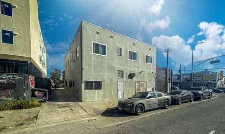
5324 S Hoover St, Los Angeles, CA 90037


This Property Is For Sale
NEARBY LISTINGS FOR SALE OR LEASE
Property Detail
5324 S Hoover St
Los Angeles-Long Beach-Glendale, CA
2936
5001-026-011
TRACT # 2936 EX E 44.5 FT LOT A
Retailwithmorethanonenonretailuse
Los Angeles
X
California
06037C1781G
a
2024
0.12 AC
2025
Vermont Harbor
232702
Los Angeles
4,268 SF
DEMOGRAPHICS near 5324 S Hoover St
1 Mile
3 Mile
5 Mile
2024 Total Population
65,637
480,356
1,208,103
2029 Population
64,767
474,039
1,196,982
Pop Growth 2024-2029
(1.33%)
(1.32%)
(0.92%)
Average Age
36
36
38
2024 Total Households
16,781
131,238
388,076
HH Growth 2024-2029
(1.60%)
(1.52%)
(0.81%)
Median Household Inc
$60,343
$55,789
$58,596
Avg Household Size
3.70
3.40
2.90
2024 Avg HH Vehicles
2.00
2.00
2.00
Median Home Value
$709,452
$723,737
$755,761
Median Year Built
1948
1948
1955
Nearby Places
Map Layers
Map Styles
 Street
 Aerial
- Restaurants
- Banks
- Shops
- Fitness
- Groceries
PUBLIC TRANSPORTATION
COMMUTER RAIL
DRIVE
WALK
Distance
11 min
6.7 mi
Union Station (91 Line - Southern California Regional Rail Authority (Metrolink), Antelope Valley Line - Southern California Regional Rail Authority (Metrolink), Orange County Line - Southern California Regional Rail Authority (Metrolink), Riverside Line - Southern California Regional Rail Authority (Metrolink), San Bernardino Line - Southern California Regional Rail Authority (Metrolink), Ventura County Line - Southern California Regional Rail Authority (Metrolink))
DRIVE
WALK
Distance
Union Station (91 Line - Southern California Regional Rail Authority (Metrolink), Antelope Valley Line - Southern California Regional Rail Authority (Metrolink), Orange County Line - Southern California Regional Rail Authority (Metrolink), Riverside Line - Southern California Regional Rail Authority (Metrolink), San Bernardino Line - Southern California Regional Rail Authority (Metrolink), Ventura County Line - Southern California Regional Rail Authority (Metrolink))
13 min
6.9 mi
AIRPORT
Los Angeles International
DRIVE
WALK
Distance
Los Angeles International
20 min
13.4 mi
Long Beach (Daugherty Field)
DRIVE
WALK
Distance
Long Beach (Daugherty Field)
26 min
18.5 mi
Bob Hope
DRIVE
WALK
Distance
Bob Hope
32 min
21.9 mi
Freight Ports
Port of Long Beach
DRIVE
WALK
Distance
Port of Long Beach
30 min
20.5 mi
Nearby Properties
Address
Land Use
TOTAL SIZE
Lot Size
Zoning
Address
Land Use
TOTAL SIZE
Lot Size
Zoning
969,516 SF
14.75 AC
Address
Land Use
TOTAL SIZE
Lot Size
Zoning
1,178,786 SF
3.89 AC
LAC2
Address
Land Use
TOTAL SIZE
Lot Size
Zoning
420,864 SF
63.07 AC
LAUSC-1A
Address
Land Use
TOTAL SIZE
Lot Size
Zoning
256,059 SF
Address
Land Use
TOTAL SIZE
Lot Size
Zoning
200,689 SF
5.79 AC
LAUSC-1A
Address
Land Use
TOTAL SIZE
Lot Size
Zoning
337,025 SF
14.59 AC
LAUSC-1A
Address
Land Use
TOTAL SIZE
Lot Size
Zoning
666,499 SF
10.63 AC
LAC2
Address
Land Use
TOTAL SIZE
Lot Size
Zoning
298,630 SF
4.64 AC
LAUSC-1B
Address
Land Use
TOTAL SIZE
Lot Size
Zoning
377,946 SF
5.03 AC
LAUSC-1A
Address
Land Use
TOTAL SIZE
Lot Size
Zoning
152,000 SF
1.04 AC
LAC2
Address
Land Use
TOTAL SIZE
Lot Size
Zoning
112,636 SF
24.20 AC
LAUSC-1A
Address
Land Use
TOTAL SIZE
Lot Size
Zoning
284,335 SF
2.01 AC
LAM1
Address
Land Use
TOTAL SIZE
Lot Size
Zoning
188,146 SF
1.54 AC
LAUSC-1A
Address
Land Use
TOTAL SIZE
Lot Size
Zoning
Address
Land Use
TOTAL SIZE
Lot Size
Zoning
1 AC
LAC2
Address
Land Use
TOTAL SIZE
Lot Size
Zoning
1 AC
LAC2
Address
Land Use
TOTAL SIZE
Lot Size
Zoning
95,639 SF
0.53 AC
LAC2
Address
Land Use
TOTAL SIZE
Lot Size
Zoning
116,827 SF
0.64 AC
LAC2
Address
Land Use
TOTAL SIZE
Lot Size
Zoning
251,338 SF
10.62 AC
LAM3
Address
Land Use
TOTAL SIZE
Lot Size
Zoning
57,488 SF
4.30 AC
LAPF
Address
Land Use
TOTAL SIZE
Lot Size
Zoning
564,529 SF
2.67 AC
LAUSC-1B
Address
Land Use
TOTAL SIZE
Lot Size
Zoning
386,865 SF
6 AC
VEM*
Address
Land Use
TOTAL SIZE
Lot Size
Zoning
150,790 SF
0.74 AC
LAC2
Address
Land Use
TOTAL SIZE
Lot Size
Zoning
122,517 SF
3.08 AC
LAR4
Address
Land Use
TOTAL SIZE
Lot Size
Zoning
261,502 SF
0.84 AC
LACM
Address
Land Use
TOTAL SIZE
Lot Size
Zoning
134,044 SF
1.90 AC
LAC2
Address
Land Use
TOTAL SIZE
Lot Size
Zoning
132,544 SF
3.24 AC
LAM2
Address
Land Use
TOTAL SIZE
Lot Size
Zoning
729,505 SF
8.74 AC
LAUSC-1A
Address
Land Use
TOTAL SIZE
Lot Size
Zoning
115,340 SF
3.21 AC
LAM2
Address
Land Use
TOTAL SIZE
Lot Size
Zoning
165,235 SF
1.13 AC
LAM2
The World's #1 Commercial Real Estate Marketplace
Connect with us
© 2026 CoStar Group
The information above has been obtained from sources believed reliable. While we do not doubt its accuracy we have not verified it and make no guarantee, warranty or representation about it. It is your responsibility to independently confirm its accuracy and completeness. Any projections, opinions, assumptions, or estimates used are for example only and do not represent the current or future performance of the property. The value of this transaction to you depends on tax and other factors which should be evaluated by your tax, financial, and legal advisors. You and your advisors should conduct a careful, independent investigation of the property to determine to your satisfaction the suitability of the property for your needs.