Property Record
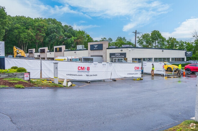
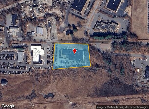
533 Boston Post Rd, Wayland, MA 01778

NEARBY LISTINGS FOR SALE OR LEASE
Property Detail
533 Boston Post Rd
WAYL-000021-000000-000003
Middlesex
Vehiclerentalsvehiclesales
Massachusetts
X
3
25017C0507F
2.95 AC
2025
Concord/Maynard
2025
Boston
366202
Boston-Cambridge-Newton, MA-NH
24,980 SF
DEMOGRAPHICS near 533 Boston Post Rd
1 Mile
3 Mile
5 Mile
2024 Total Population
1,956
29,487
89,008
2029 Population
1,968
29,290
88,356
Pop Growth 2024-2029
+ 0.61%
(0.67%)
(0.73%)
Average Age
44
43
43
2024 Total Households
711
10,945
33,086
HH Growth 2024-2029
+ 0.70%
(0.78%)
(0.83%)
Median Household Inc
$215,544
$176,193
$159,117
Avg Household Size
2.70
2.60
2.60
2024 Avg HH Vehicles
2.00
2.00
2.00
Median Home Value
$898,507
$756,843
$764,128
Median Year Built
1982
1965
1966
Nearby Places
Map Layers
Map Styles
 Street
 Aerial
- Restaurants
- Banks
- Shops
- Fitness
- Groceries
PUBLIC TRANSPORTATION
COMMUTER RAIL
Kendal Green (Fitchburg/South Acton Line - Massachusetts Bay Transportation Authority Commuter Rail (Purple Line))
DRIVE
WALK
Distance
Kendal Green (Fitchburg/South Acton Line - Massachusetts Bay Transportation Authority Commuter Rail (Purple Line))
13 min
6.4 mi
Lincoln (Fitchburg/South Acton Line - Massachusetts Bay Transportation Authority Commuter Rail (Purple Line))
DRIVE
WALK
Distance
Lincoln (Fitchburg/South Acton Line - Massachusetts Bay Transportation Authority Commuter Rail (Purple Line))
13 min
6.6 mi
AIRPORT
General Edward Lawrence Logan International
DRIVE
WALK
Distance
General Edward Lawrence Logan International
38 min
22.8 mi
Worcester Regional
DRIVE
WALK
Distance
Worcester Regional
49 min
31.0 mi
Freight Ports
Port of Boston
DRIVE
WALK
Distance
Port of Boston
37 min
21.2 mi
Nearby Properties
Address
Land Use
TOTAL SIZE
Lot Size
Zoning
Address
Land Use
TOTAL SIZE
Lot Size
Zoning
24.78 AC
LID
Address
Land Use
TOTAL SIZE
Lot Size
Zoning
87,102 SF
8.26 AC
R40
Address
Land Use
TOTAL SIZE
Lot Size
Zoning
136,919 SF
13.42 AC
M
Address
Land Use
TOTAL SIZE
Lot Size
Zoning
51,524 SF
67.86 AC
R40
Address
Land Use
TOTAL SIZE
Lot Size
Zoning
225,181 SF
93.94 AC
RESA
Address
Land Use
TOTAL SIZE
Lot Size
Zoning
182,736 SF
7.30 AC
B2
Address
Land Use
TOTAL SIZE
Lot Size
Zoning
114,000 SF
31.53 AC
PRD
Address
Land Use
TOTAL SIZE
Lot Size
Zoning
44,301 SF
11.50 AC
LC
Address
Land Use
TOTAL SIZE
Lot Size
Zoning
162,704 SF
26.50 AC
RESA
Address
Land Use
TOTAL SIZE
Lot Size
Zoning
26.16 AC
LID
Address
Land Use
TOTAL SIZE
Lot Size
Zoning
27.16 AC
RESA
Address
Land Use
TOTAL SIZE
Lot Size
Zoning
28.26 AC
LID
Address
Land Use
TOTAL SIZE
Lot Size
Zoning
53.75 AC
Address
Land Use
TOTAL SIZE
Lot Size
Zoning
56,202 SF
37 AC
R30
Address
Land Use
TOTAL SIZE
Lot Size
Zoning
9.26 AC
LBD
Address
Land Use
TOTAL SIZE
Lot Size
Zoning
60,193 SF
15.67 AC
ID
Address
Land Use
TOTAL SIZE
Lot Size
Zoning
66,589 SF
25.82 AC
R60
Address
Land Use
TOTAL SIZE
Lot Size
Zoning
63,600 SF
12.75 AC
R3
Address
Land Use
TOTAL SIZE
Lot Size
Zoning
74,133 SF
7.32 AC
ID
Address
Land Use
TOTAL SIZE
Lot Size
Zoning
166,800 SF
8.43 AC
M
Address
Land Use
TOTAL SIZE
Lot Size
Zoning
9.66 AC
LBD
Address
Land Use
TOTAL SIZE
Lot Size
Zoning
59,600 SF
3.19 AC
R1
Address
Land Use
TOTAL SIZE
Lot Size
Zoning
55,338 SF
0.96 AC
B2
Address
Land Use
TOTAL SIZE
Lot Size
Zoning
8.28 AC
LID
Address
Land Use
TOTAL SIZE
Lot Size
Zoning
43,302 SF
4.70 AC
LID
Address
Land Use
TOTAL SIZE
Lot Size
Zoning
22.61 AC
RESC
Address
Land Use
TOTAL SIZE
Lot Size
Zoning
59,681 SF
21.26 AC
RESC
Address
Land Use
TOTAL SIZE
Lot Size
Zoning
9,050 SF
1 AC
R3
Address
Land Use
TOTAL SIZE
Lot Size
Zoning
6.30 AC
VBD
Address
Land Use
TOTAL SIZE
Lot Size
Zoning
31,940 SF
6.44 AC
R30
The World's #1 Commercial Real Estate Marketplace
Connect with us
© 2026 CoStar Group
The information above has been obtained from sources believed reliable. While we do not doubt its accuracy we have not verified it and make no guarantee, warranty or representation about it. It is your responsibility to independently confirm its accuracy and completeness. Any projections, opinions, assumptions, or estimates used are for example only and do not represent the current or future performance of the property. The value of this transaction to you depends on tax and other factors which should be evaluated by your tax, financial, and legal advisors. You and your advisors should conduct a careful, independent investigation of the property to determine to your satisfaction the suitability of the property for your needs.