Property Record
533 Sunhill Rd Nw, Center Point, AL 35215


NEARBY LISTINGS FOR SALE OR LEASE
-
-
View all Center Point listings for sale on LoopNet.com
Property Detail
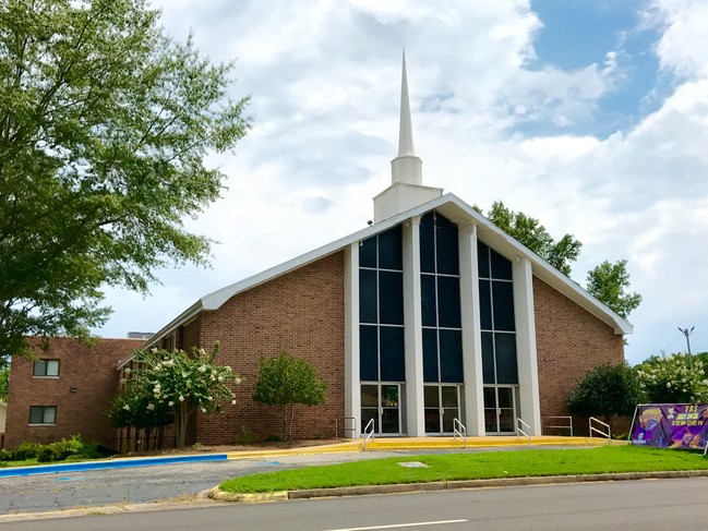
533 Sunhill Rd Nw
Birmingham, AL
Hilldales 1St Add
13-00-12-4-011-001.000
BEG NE COR OF LOT 1 HILLDALES 1ST ADDITION PB 78 PG 26 TH W 564.5 FT TH N 840 FT TH NELY ALG R/W 625 FT TH S 1085 FT TO POB
Auditorium
Jefferson
X
Alabama
01073C0239H
1
0
12.40 AC
2024
Fultondale
011804
Birmingham
29,932 SF
DEMOGRAPHICS near 533 Sunhill Rd Nw
1 Mile
3 Mile
5 Mile
2024 Total Population
6,269
43,608
81,455
2029 Population
6,174
42,905
79,744
Pop Growth 2024-2029
(1.52%)
(1.61%)
(2.10%)
Average Age
35
36
38
2024 Total Households
2,364
16,245
30,883
HH Growth 2024-2029
(1.57%)
(1.65%)
(2.14%)
Median Household Inc
$39,476
$44,672
$50,973
Avg Household Size
2.60
2.60
2.60
2024 Avg HH Vehicles
2.00
2.00
2.00
Median Home Value
$144,560
$143,878
$151,329
Median Year Built
1972
1975
1976
Nearby Places
Map Layers
Map Styles
 Street
 Aerial
- Restaurants
- Banks
- Shops
- Fitness
- Groceries
PUBLIC TRANSPORTATION
AIRPORT
Birmingham-Shuttlesworth International
DRIVE
WALK
Distance
Birmingham-Shuttlesworth International
22 min
11.0 mi
Freight Ports
Port of Mobile
DRIVE
WALK
Distance
Port of Mobile
303 min
269.7 mi
SALE & LEASE HISTORY
LISTING DATE
SALE/LEASE

Sep 20, 2017
For Sale
Nearby Properties
Address
Land Use
TOTAL SIZE
Lot Size
Zoning
Address
Land Use
TOTAL SIZE
Lot Size
Zoning
725,840 SF
89 AC
CM2
Address
Land Use
TOTAL SIZE
Lot Size
Zoning
150,160 SF
12 AC
INST
Address
Land Use
TOTAL SIZE
Lot Size
Zoning
1 SF
7.08 AC
CB2
Address
Land Use
TOTAL SIZE
Lot Size
Zoning
207,383 SF
17 AC
CR5
Address
Land Use
TOTAL SIZE
Lot Size
Zoning
623,200 SF
50 AC
CM2
Address
Land Use
TOTAL SIZE
Lot Size
Zoning
218,922 SF
21 AC
CR5
Address
Land Use
TOTAL SIZE
Lot Size
Zoning
412,320 SF
16.50 AC
I2
Address
Land Use
TOTAL SIZE
Lot Size
Zoning
192,596 SF
13.79 AC
CR5
Address
Land Use
TOTAL SIZE
Lot Size
Zoning
147,200 SF
7.93 AC
CR5
Address
Land Use
TOTAL SIZE
Lot Size
Zoning
118,522 SF
7.80 AC
I4
Address
Land Use
TOTAL SIZE
Lot Size
Zoning
531,808 SF
23.96 AC
I4&A
Address
Land Use
TOTAL SIZE
Lot Size
Zoning
502,302 SF
24.61 AC
I4&A
Address
Land Use
TOTAL SIZE
Lot Size
Zoning
95,172 SF
6.40 AC
R2
Address
Land Use
TOTAL SIZE
Lot Size
Zoning
125,252 SF
8.07 AC
R4
Address
Land Use
TOTAL SIZE
Lot Size
Zoning
116,732 SF
4.06 AC
R-4
Address
Land Use
TOTAL SIZE
Lot Size
Zoning
163,790 SF
18 AC
I-4
Address
Land Use
TOTAL SIZE
Lot Size
Zoning
179,464 SF
17.70 AC
M3
Address
Land Use
TOTAL SIZE
Lot Size
Zoning
86,434 SF
8.20 AC
QM1
Address
Land Use
TOTAL SIZE
Lot Size
Zoning
80,834 SF
7.13 AC
CR5
Address
Land Use
TOTAL SIZE
Lot Size
Zoning
43,451 SF
5.22 AC
INST
Address
Land Use
TOTAL SIZE
Lot Size
Zoning
340,000 SF
29 AC
I4
Address
Land Use
TOTAL SIZE
Lot Size
Zoning
26,169 SF
71 AC
R2
Address
Land Use
TOTAL SIZE
Lot Size
Zoning
109,878 SF
10 AC
C1
Address
Land Use
TOTAL SIZE
Lot Size
Zoning
115,544 SF
12 AC
CB2
Address
Land Use
TOTAL SIZE
Lot Size
Zoning
74,159 SF
2.50 AC
INST
Address
Land Use
TOTAL SIZE
Lot Size
Zoning
56,360 SF
2.80 AC
INST
Address
Land Use
TOTAL SIZE
Lot Size
Zoning
257,988 SF
CM2
Address
Land Use
TOTAL SIZE
Lot Size
Zoning
63,736 SF
11 AC
I
Address
Land Use
TOTAL SIZE
Lot Size
Zoning
84,602 SF
11.20 AC
B2
The World's #1 Commercial Real Estate Marketplace
Connect with us
© 2026 CoStar Group
The information above has been obtained from sources believed reliable. While we do not doubt its accuracy we have not verified it and make no guarantee, warranty or representation about it. It is your responsibility to independently confirm its accuracy and completeness. Any projections, opinions, assumptions, or estimates used are for example only and do not represent the current or future performance of the property. The value of this transaction to you depends on tax and other factors which should be evaluated by your tax, financial, and legal advisors. You and your advisors should conduct a careful, independent investigation of the property to determine to your satisfaction the suitability of the property for your needs.