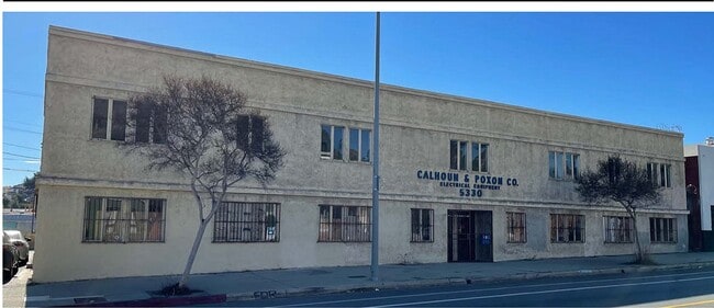
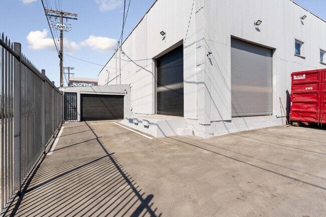
Property Record
5330 Alhambra Ave, Los Angeles, CA 90032


NEARBY LISTINGS FOR SALE OR LEASE
Property Detail
5330 Alhambra Ave
Los Angeles-Long Beach-Glendale, CA
6900
5217-019-019
TRACT # 6900 LOTS 337,338,339, 340,341 AND LOT 342
Lightindustrial
Los Angeles
X
California
06037C1635F
337
2025
0.34 AC
2025
Central Los Angeles
201602
Los Angeles
10,302 SF
DEMOGRAPHICS near 5330 Alhambra Ave
1 Mile
3 Mile
5 Mile
2024 Total Population
28,013
284,623
726,999
2029 Population
27,070
274,386
700,686
Pop Growth 2024-2029
(3.37%)
(3.60%)
(3.62%)
Average Age
39
40
40
2024 Total Households
8,430
93,351
242,214
HH Growth 2024-2029
(3.64%)
(3.82%)
(3.77%)
Median Household Inc
$71,669
$71,647
$73,153
Avg Household Size
3.10
2.90
2.80
2024 Avg HH Vehicles
2.00
2.00
2.00
Median Home Value
$738,359
$775,679
$796,402
Median Year Built
1951
1955
1956
Nearby Places
Map Layers
Map Styles
 Street
 Aerial
- Restaurants
- Banks
- Shops
- Fitness
- Groceries
PUBLIC TRANSPORTATION
COMMUTER RAIL
Union Station (91 Line - Southern California Regional Rail Authority (Metrolink), Antelope Valley Line - Southern California Regional Rail Authority (Metrolink), Orange County Line - Southern California Regional Rail Authority (Metrolink), Riverside Line - Southern California Regional Rail Authority (Metrolink), San Bernardino Line - Southern California Regional Rail Authority (Metrolink), Ventura County Line - Southern California Regional Rail Authority (Metrolink))
DRIVE
WALK
Distance
Union Station (91 Line - Southern California Regional Rail Authority (Metrolink), Antelope Valley Line - Southern California Regional Rail Authority (Metrolink), Orange County Line - Southern California Regional Rail Authority (Metrolink), Riverside Line - Southern California Regional Rail Authority (Metrolink), San Bernardino Line - Southern California Regional Rail Authority (Metrolink), Ventura County Line - Southern California Regional Rail Authority (Metrolink))
11 min
4.8 mi
Cal State La Metrolink Station (Metrolink San Bernardino Line - Metrolink Trains)
DRIVE
WALK
Distance
Cal State La Metrolink Station (Metrolink San Bernardino Line - Metrolink Trains)
13 min
9.4 mi
AIRPORT
Bob Hope
DRIVE
WALK
Distance
Bob Hope
28 min
18.9 mi
Los Angeles International
DRIVE
WALK
Distance
Los Angeles International
35 min
21.5 mi
Long Beach (Daugherty Field)
DRIVE
WALK
Distance
Long Beach (Daugherty Field)
32 min
22.3 mi
Freight Ports
Port of Long Beach
DRIVE
WALK
Distance
Port of Long Beach
34 min
25.1 mi
SALE & LEASE HISTORY
LISTING DATE
SALE/LEASE

Mar 11, 2021
For Lease
Mar 11, 2021
For Sale
Jul 27, 2023
For Lease
Nearby Properties
Address
Land Use
TOTAL SIZE
Lot Size
Zoning
Address
Land Use
TOTAL SIZE
Lot Size
Zoning
513,825 SF
4.28 AC
LAC2
Address
Land Use
TOTAL SIZE
Lot Size
Zoning
534,225 SF
Address
Land Use
TOTAL SIZE
Lot Size
Zoning
460,590 SF
23.95 AC
ALMPD*
Address
Land Use
TOTAL SIZE
Lot Size
Zoning
328,737 SF
7.92 AC
LAC2
Address
Land Use
TOTAL SIZE
Lot Size
Zoning
354,299 SF
2.18 AC
LAC2
Address
Land Use
TOTAL SIZE
Lot Size
Zoning
150,608 SF
0.88 AC
LAC2
Address
Land Use
TOTAL SIZE
Lot Size
Zoning
516,474 SF
4.37 AC
ALCBD/DRD*
Address
Land Use
TOTAL SIZE
Lot Size
Zoning
119,455 SF
5.04 AC
LACM
Address
Land Use
TOTAL SIZE
Lot Size
Zoning
151,450 SF
6.59 AC
MPSP*
Address
Land Use
TOTAL SIZE
Lot Size
Zoning
220,717 SF
2.14 AC
MPSP*
Address
Land Use
TOTAL SIZE
Lot Size
Zoning
252,559 SF
2.87 AC
LAC2
Address
Land Use
TOTAL SIZE
Lot Size
Zoning
172,072 SF
1.82 AC
LAC2
Address
Land Use
TOTAL SIZE
Lot Size
Zoning
75,589 SF
0.98 AC
LAC2
Address
Land Use
TOTAL SIZE
Lot Size
Zoning
198,958 SF
7.50 AC
LCM2*
Address
Land Use
TOTAL SIZE
Lot Size
Zoning
116,109 SF
0.92 AC
LACM
Address
Land Use
TOTAL SIZE
Lot Size
Zoning
116,480 SF
11.81 AC
MPC2
Address
Land Use
TOTAL SIZE
Lot Size
Zoning
77,778 SF
2.87 AC
ALRPD*
Address
Land Use
TOTAL SIZE
Lot Size
Zoning
188,634 SF
1.07 AC
LAUI(CA)
Address
Land Use
TOTAL SIZE
Lot Size
Zoning
296,309 SF
5.29 AC
LAM1
Address
Land Use
TOTAL SIZE
Lot Size
Zoning
130,189 SF
6.59 AC
MPOPCD*
Address
Land Use
TOTAL SIZE
Lot Size
Zoning
146,264 SF
1.87 AC
LAMR1
Address
Land Use
TOTAL SIZE
Lot Size
Zoning
288,700 SF
6.19 AC
MPOP*
Address
Land Use
TOTAL SIZE
Lot Size
Zoning
155,339 SF
3.99 AC
LAMR1
Address
Land Use
TOTAL SIZE
Lot Size
Zoning
92,530 SF
3.16 AC
LARD1.5
Address
Land Use
TOTAL SIZE
Lot Size
Zoning
203,860 SF
1.92 AC
MPSP*
Address
Land Use
TOTAL SIZE
Lot Size
Zoning
119,883 SF
5.93 AC
MPOP*
Address
Land Use
TOTAL SIZE
Lot Size
Zoning
435,600 SF
10.57 AC
LACM
Address
Land Use
TOTAL SIZE
Lot Size
Zoning
82,188 SF
1.20 AC
ALCBD/DRD*
Address
Land Use
TOTAL SIZE
Lot Size
Zoning
182,254 SF
2.14 AC
LAUV(CA)
Address
Land Use
TOTAL SIZE
Lot Size
Zoning
121,733 SF
5.59 AC
ALMPD*
The World's #1 Commercial Real Estate Marketplace
Connect with us
© 2025 CoStar Group
The information above has been obtained from sources believed reliable. While we do not doubt its accuracy we have not verified it and make no guarantee, warranty or representation about it. It is your responsibility to independently confirm its accuracy and completeness. Any projections, opinions, assumptions, or estimates used are for example only and do not represent the current or future performance of the property. The value of this transaction to you depends on tax and other factors which should be evaluated by your tax, financial, and legal advisors. You and your advisors should conduct a careful, independent investigation of the property to determine to your satisfaction the suitability of the property for your needs.