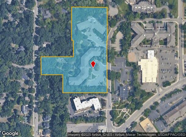
Property Record
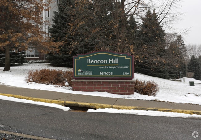
5330 Beacon Hill Rd, Minnetonka, MN 55345

NEARBY LISTINGS FOR SALE OR LEASE
Property Detail
5330 Beacon Hill Rd
Minneapolis-St. Paul-Bloomington, MN-WI
Beacon Hill
28-117-22-44-0366
LOT 001 BLOCK 001 T BEACON HILL IRREGULAR
Apartment
Hennepin
X
Minnesota
27053C0337F
1
2024
7.06 AC
2024
West Minnetonka
026206
Minneapolis/St Paul
DEMOGRAPHICS near 5330 Beacon Hill Rd
1 mile
3 mile
5 mile
2024 Total Population
5,813
58,173
156,682
2029 Population
5,672
57,171
155,260
Pop Growth 2024-2029
(2.43%)
(1.72%)
(0.91%)
Average Age
47
43
42
2024 Total Households
2,443
24,537
66,213
HH Growth 2024-2029
(2.62%)
(1.77%)
(1.01%)
Median Household Inc
$113,970
$103,036
$103,662
Avg Household Size
2.30
2.30
2.30
2024 Avg HH Vehicles
2.00
2.00
2.00
Median Home Value
$438,747
$392,412
$426,949
Median Year Built
1973
1979
1981
Nearby Places
Map Layers
Map Styles
 Street
 Aerial
Transit
 Traffic
 Biking
Places
Listings with unknown addresses are not visible on the map
- Restaurants
- Banks
- Shops
- Fitness
- Groceries
PUBLIC TRANSPORTATION
AIRPORT
Minneapolis-St Paul International/Wold-Chamberlain
Drive
Walk
Distance
Minneapolis-St Paul International/Wold-Chamberlain
24 min
16.0 mi
Freight Ports
Port Milwaukee
Drive
Walk
Distance
Port Milwaukee
392 min
351.3 mi
Nearby Properties
Address
Land Use
TOTAL SIZE
Lot Size
Zoning
Address
Land Use
TOTAL SIZE
Lot Size
Zoning
7.68 AC
Address
Land Use
TOTAL SIZE
Lot Size
Zoning
4.89 AC
Address
Land Use
TOTAL SIZE
Lot Size
Zoning
0.90 AC
Address
Land Use
TOTAL SIZE
Lot Size
Zoning
3.07 AC
Address
Land Use
TOTAL SIZE
Lot Size
Zoning
4.84 AC
Address
Land Use
TOTAL SIZE
Lot Size
Zoning
138,997 SF
14.03 AC
OFC
Address
Land Use
TOTAL SIZE
Lot Size
Zoning
4.55 AC
Address
Land Use
TOTAL SIZE
Lot Size
Zoning
3.15 AC
Address
Land Use
TOTAL SIZE
Lot Size
Zoning
233,320 SF
17.37 AC
PUD
Address
Land Use
TOTAL SIZE
Lot Size
Zoning
93,982 SF
9.33 AC
OFC
Address
Land Use
TOTAL SIZE
Lot Size
Zoning
314,234 SF
2.31 AC
RM25
Address
Land Use
TOTAL SIZE
Lot Size
Zoning
122,801 SF
8.41 AC
RM25
Address
Land Use
TOTAL SIZE
Lot Size
Zoning
13.43 AC
Address
Land Use
TOTAL SIZE
Lot Size
Zoning
4.08 AC
PUD
Address
Land Use
TOTAL SIZE
Lot Size
Zoning
8.38 AC
PUD
Address
Land Use
TOTAL SIZE
Lot Size
Zoning
46,726 SF
2.65 AC
PUD
Address
Land Use
TOTAL SIZE
Lot Size
Zoning
70,129 SF
13.03 AC
RM25
Address
Land Use
TOTAL SIZE
Lot Size
Zoning
129,037 SF
16.73 AC
RM25
Address
Land Use
TOTAL SIZE
Lot Size
Zoning
11.56 AC
Address
Land Use
TOTAL SIZE
Lot Size
Zoning
29,078 SF
12.84 AC
PUD
Address
Land Use
TOTAL SIZE
Lot Size
Zoning
20.18 AC
RM65
Address
Land Use
TOTAL SIZE
Lot Size
Zoning
2,676 SF
3.17 AC
PUD
Address
Land Use
TOTAL SIZE
Lot Size
Zoning
7.38 AC
Address
Land Use
TOTAL SIZE
Lot Size
Zoning
49,925 SF
18.37 AC
B1
Address
Land Use
TOTAL SIZE
Lot Size
Zoning
129,168 SF
16.01 AC
PUD
Address
Land Use
TOTAL SIZE
Lot Size
Zoning
7,209 SF
2.53 AC
B1
Address
Land Use
TOTAL SIZE
Lot Size
Zoning
87,000 SF
5.27 AC
R5
Address
Land Use
TOTAL SIZE
Lot Size
Zoning
23.66 AC
Address
Land Use
TOTAL SIZE
Lot Size
Zoning
47,443 SF
10.11 AC
RM25
The World's #1 Commercial Real Estate Marketplace
Connect with us
© 2026 CoStar Group
The information above has been obtained from sources believed reliable. While we do not doubt its accuracy we have not verified it and make no guarantee, warranty or representation about it. It is your responsibility to independently confirm its accuracy and completeness. Any projections, opinions, assumptions, or estimates used are for example only and do not represent the current or future performance of the property. The value of this transaction to you depends on tax and other factors which should be evaluated by your tax, financial, and legal advisors. You and your advisors should conduct a careful, independent investigation of the property to determine to your satisfaction the suitability of the property for your needs.