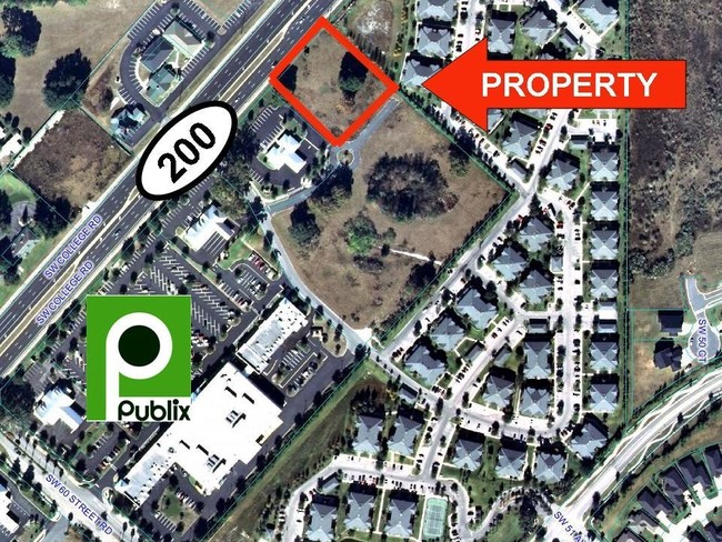
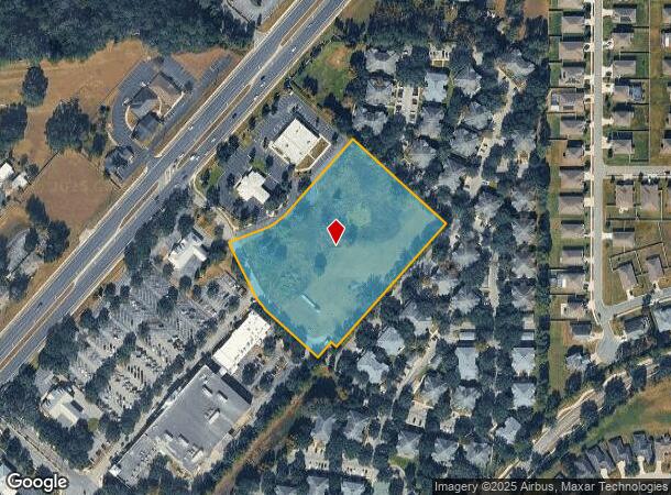
Property Record
5350 Sw College Rd, Ocala, FL 34474
NEARBY LISTINGS FOR SALE OR LEASE
Property Detail
5350 Sw College Rd
Ocala, FL
Heath Brook South B-2
2389-100-002
SEC 04 TWP 16 RGE 21 PLAT BOOK 013 PAGE 105 HEATH BROOK SOUTH B-2 PARCEL 2 REPLAT PARCEL 2C
Commercialacreage
Marion
X
Florida
12083C0514E
2
2024
5.21 AC
2024
Greater Ocala
002505
Ocala
DEMOGRAPHICS near 5350 Sw College Rd
1 Mile
3 Mile
5 Mile
2024 Total Population
3,747
23,138
67,185
2029 Population
4,212
26,137
76,073
Pop Growth 2024-2029
+ 12.41%
+ 12.96%
+ 13.23%
Average Age
48
44
49
2024 Total Households
1,784
9,770
28,930
HH Growth 2024-2029
+ 12.44%
+ 12.93%
+ 13.25%
Median Household Inc
$54,610
$59,004
$56,671
Avg Household Size
2.10
2.30
2.20
2024 Avg HH Vehicles
2.00
2.00
2.00
Median Home Value
$92,667
$217,094
$227,712
Median Year Built
1996
1995
1996
Nearby Places
- Restaurants
- Banks
- Shops
- Fitness
- Groceries
SALE & LEASE HISTORY
LISTING DATE
SALE/LEASE

Sep 12, 2017
For Sale
Nearby Properties
Address
Land Use
TOTAL SIZE
Lot Size
Zoning
Address
Land Use
TOTAL SIZE
Lot Size
Zoning
156,201 SF
36.77 AC
INST
Address
Land Use
TOTAL SIZE
Lot Size
Zoning
283,913 SF
24.22 AC
B2
Address
Land Use
TOTAL SIZE
Lot Size
Zoning
164,363 SF
16.51 AC
R3
Address
Land Use
TOTAL SIZE
Lot Size
Zoning
422,264 SF
40.87 AC
SC
Address
Land Use
TOTAL SIZE
Lot Size
Zoning
154,870 SF
23.50 AC
PD
Address
Land Use
TOTAL SIZE
Lot Size
Zoning
324,262 SF
48.94 AC
SC
Address
Land Use
TOTAL SIZE
Lot Size
Zoning
189,662 SF
25.54 AC
B2
Address
Land Use
TOTAL SIZE
Lot Size
Zoning
154,675 SF
23.62 AC
PD09
Address
Land Use
TOTAL SIZE
Lot Size
Zoning
37,448 SF
35.67 AC
PD
Address
Land Use
TOTAL SIZE
Lot Size
Zoning
155,077 SF
40.05 AC
PUD
Address
Land Use
TOTAL SIZE
Lot Size
Zoning
111,644 SF
19 AC
PD09
Address
Land Use
TOTAL SIZE
Lot Size
Zoning
110,226 SF
19.56 AC
PD09
Address
Land Use
TOTAL SIZE
Lot Size
Zoning
41,233 SF
23.19 AC
R3
Address
Land Use
TOTAL SIZE
Lot Size
Zoning
124,557 SF
39.04 AC
GU
Address
Land Use
TOTAL SIZE
Lot Size
Zoning
43,905 SF
6.29 AC
B2
Address
Land Use
TOTAL SIZE
Lot Size
Zoning
59,706 SF
10.01 AC
PD
Address
Land Use
TOTAL SIZE
Lot Size
Zoning
186,474 SF
18.52 AC
SC
Address
Land Use
TOTAL SIZE
Lot Size
Zoning
80,532 SF
53.56 AC
INST
Address
Land Use
TOTAL SIZE
Lot Size
Zoning
37,601 SF
3.71 AC
B2
Address
Land Use
TOTAL SIZE
Lot Size
Zoning
65,882 SF
13.34 AC
R3
Address
Land Use
TOTAL SIZE
Lot Size
Zoning
95,496 SF
25.25 AC
R3
Address
Land Use
TOTAL SIZE
Lot Size
Zoning
78,719 SF
7.42 AC
PD09
Address
Land Use
TOTAL SIZE
Lot Size
Zoning
39,411 SF
3.35 AC
B2
Address
Land Use
TOTAL SIZE
Lot Size
Zoning
55,985 SF
21.78 AC
B4
Address
Land Use
TOTAL SIZE
Lot Size
Zoning
23,441 SF
2.33 AC
B2
Address
Land Use
TOTAL SIZE
Lot Size
Zoning
16,016 SF
2.63 AC
B2
Address
Land Use
TOTAL SIZE
Lot Size
Zoning
44,276 SF
5 AC
O1
Address
Land Use
TOTAL SIZE
Lot Size
Zoning
10,494 SF
1.63 AC
B2
Address
Land Use
TOTAL SIZE
Lot Size
Zoning
61,948 SF
7.64 AC
PD
Address
Land Use
TOTAL SIZE
Lot Size
Zoning
69,136 SF
10.40 AC
PD07
The World's #1 Commercial Real Estate Marketplace
Connect with us
© 2025 CoStar Group
The information above has been obtained from sources believed reliable. While we do not doubt its accuracy we have not verified it and make no guarantee, warranty or representation about it. It is your responsibility to independently confirm its accuracy and completeness. Any projections, opinions, assumptions, or estimates used are for example only and do not represent the current or future performance of the property. The value of this transaction to you depends on tax and other factors which should be evaluated by your tax, financial, and legal advisors. You and your advisors should conduct a careful, independent investigation of the property to determine to your satisfaction the suitability of the property for your needs.