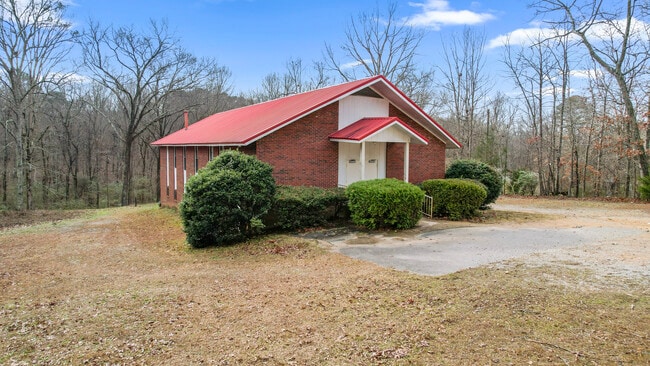
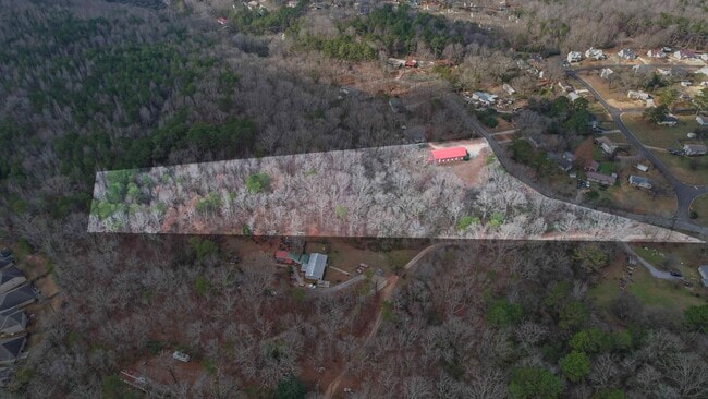
Property Record
5331 Dewey Heights Rd, Pinson, AL 35126

NEARBY LISTINGS FOR SALE OR LEASE
-
-
View all Pinson listings for sale on LoopNet.com
Property Detail
5331 Dewey Heights Rd
09-00-28-1-000-003.004
BEG SE COR OF SW 1/4 OF NE 1/4 SEC 28 TP 15 R 1W TH N 1238 FT TH SWLY 650 FT TH SE 827.3 FT TH E 148.4 FT TO POB
Religious
Jefferson
X
Alabama
01073C0234J
5.80 AC
2023
Center Point
2024
Birmingham
011206
Birmingham-Hoover, AL
5,904 SF
DEMOGRAPHICS near 5331 Dewey Heights Rd
1 Mile
3 Mile
5 Mile
2024 Total Population
2,399
14,872
47,482
2029 Population
2,309
14,264
45,856
Pop Growth 2024-2029
(3.75%)
(4.09%)
(3.42%)
Average Age
38
40
38
2024 Total Households
864
5,477
17,627
HH Growth 2024-2029
(3.82%)
(4.22%)
(3.55%)
Median Household Inc
$58,774
$72,243
$58,847
Avg Household Size
2.70
2.70
2.60
2024 Avg HH Vehicles
2.00
2.00
2.00
Median Home Value
$168,801
$168,646
$163,166
Median Year Built
1990
1987
1983
Nearby Places
Map Layers
Map Styles
 Street
 Aerial
- Restaurants
- Banks
- Shops
- Fitness
- Groceries
PUBLIC TRANSPORTATION
AIRPORT
Birmingham-Shuttlesworth International
DRIVE
WALK
Distance
Birmingham-Shuttlesworth International
30 min
16.6 mi
Freight Ports
Port of Mobile
DRIVE
WALK
Distance
Port of Mobile
308 min
273.7 mi
Nearby Properties
Address
Land Use
TOTAL SIZE
Lot Size
Zoning
Address
Land Use
TOTAL SIZE
Lot Size
Zoning
117,342 SF
36 AC
I
Address
Land Use
TOTAL SIZE
Lot Size
Zoning
81,817 SF
9.30 AC
C1
Address
Land Use
TOTAL SIZE
Lot Size
Zoning
56,504 SF
2 AC
C1-C
Address
Land Use
TOTAL SIZE
Lot Size
Zoning
63,736 SF
11 AC
I
Address
Land Use
TOTAL SIZE
Lot Size
Zoning
42,000 SF
5.10 AC
C1
Address
Land Use
TOTAL SIZE
Lot Size
Zoning
45,855 SF
5.41 AC
QC2
Address
Land Use
TOTAL SIZE
Lot Size
Zoning
45,806 SF
9 AC
INST
Address
Land Use
TOTAL SIZE
Lot Size
Zoning
58,816 SF
2.98 AC
C1
Address
Land Use
TOTAL SIZE
Lot Size
Zoning
34,755 SF
1.28 AC
INST
Address
Land Use
TOTAL SIZE
Lot Size
Zoning
20,625 SF
5.30 AC
A1IN
Address
Land Use
TOTAL SIZE
Lot Size
Zoning
12,871 SF
2.52 AC
C1
Address
Land Use
TOTAL SIZE
Lot Size
Zoning
10,360 SF
1.26 AC
C1&A
Address
Land Use
TOTAL SIZE
Lot Size
Zoning
16,385 SF
2.20 AC
C1
Address
Land Use
TOTAL SIZE
Lot Size
Zoning
12,683 SF
0.54 AC
C1
Address
Land Use
TOTAL SIZE
Lot Size
Zoning
1,350 SF
96 AC
C1
Address
Land Use
TOTAL SIZE
Lot Size
Zoning
28,952 SF
5.40 AC
A1
Address
Land Use
TOTAL SIZE
Lot Size
Zoning
19,512 SF
7.10 AC
I1
Address
Land Use
TOTAL SIZE
Lot Size
Zoning
5,458 SF
2.42 AC
C1
Address
Land Use
TOTAL SIZE
Lot Size
Zoning
11,100 SF
1.40 AC
C1
Address
Land Use
TOTAL SIZE
Lot Size
Zoning
9,350 SF
1.97 AC
C2
Address
Land Use
TOTAL SIZE
Lot Size
Zoning
8,230 SF
3.80 AC
I1
Address
Land Use
TOTAL SIZE
Lot Size
Zoning
1,716 SF
14.28 AC
C1
Address
Land Use
TOTAL SIZE
Lot Size
Zoning
10,504 SF
1.61 AC
I-1
Address
Land Use
TOTAL SIZE
Lot Size
Zoning
13,372 SF
1.40 AC
I1-C
Address
Land Use
TOTAL SIZE
Lot Size
Zoning
10,107 SF
1.46 AC
C1
Address
Land Use
TOTAL SIZE
Lot Size
Zoning
14,340 SF
2.14 AC
INST
Address
Land Use
TOTAL SIZE
Lot Size
Zoning
11,334 SF
4.17 AC
INST
Address
Land Use
TOTAL SIZE
Lot Size
Zoning
3,334 SF
1.11 AC
C1
Address
Land Use
TOTAL SIZE
Lot Size
Zoning
2,790 SF
1.02 AC
C1
Address
Land Use
TOTAL SIZE
Lot Size
Zoning
28,078 SF
7.90 AC
R2
The World's #1 Commercial Real Estate Marketplace
Connect with us
© 2026 CoStar Group
The information above has been obtained from sources believed reliable. While we do not doubt its accuracy we have not verified it and make no guarantee, warranty or representation about it. It is your responsibility to independently confirm its accuracy and completeness. Any projections, opinions, assumptions, or estimates used are for example only and do not represent the current or future performance of the property. The value of this transaction to you depends on tax and other factors which should be evaluated by your tax, financial, and legal advisors. You and your advisors should conduct a careful, independent investigation of the property to determine to your satisfaction the suitability of the property for your needs.