Property Record
5331 Hamilton Wolfe Rd, San Antonio, TX 78229

Save to a Folder
{{folder.Name}}
{{folder.ListingIds.length}} Properties
{{folder.ListingIds.length}} Property
Create a New Folder
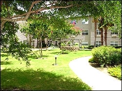
Property Detail
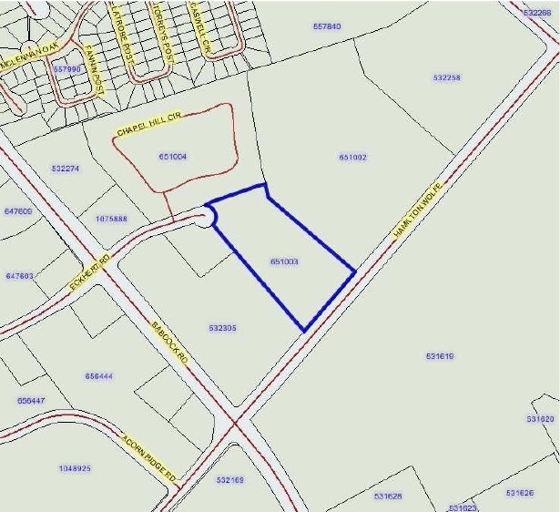
5331 Hamilton Wolfe Rd
San Antonio-New Braunfels, TX
NCB 17339 BLK 1 LOT 132 EXC SW TRI 57.39 FT (REGENT-HAMILTON WOLFE) 2016-RESURVEY ACCT PER DEED 17438/1412 EXE 8-27-15. LR/GIS/2-17-16. 2011-MAP & LEGAL CORRECTION PER DEED 14448/2273 EXE 4-20-2010.
17339-001-1320
BEXAR
Governmentalpublicusegeneral
Texas
B and X Area of moderate flood hazard, usually the area between the limits of the 100-year and 500-year floods.
132
2025
4.47 AC
2025
Northwest
181404
San Antonio
93,470 SF
NEARBY LISTINGS FOR SALE OR LEASE
-
-
View all San Antonio listings for sale on LoopNet.com
DEMOGRAPHICS near 5331 Hamilton Wolfe Rd
1 mile
3 mile
5 mile
2025 Total Population
23,546
145,657
370,133
2030 Population
24,881
152,966
387,152
Pop Growth 2025-2030
+ 5.67%
+ 5.02%
+ 4.60%
Average Age
35
37
38
2025 Total Households
11,964
65,848
152,079
HH Growth 2025-2030
+ 5.83%
+ 5.26%
+ 4.88%
Median Household Inc
$56,659
$56,623
$61,880
Avg Household Size
1.90
2.20
2.40
2025 Avg HH Vehicles
1.00
1.00
2.00
Median Home Value
$243,737
$265,819
$270,740
Median Year Built
1993
1985
1985
Nearby Places
Map Layers
Map Styles
 Street
 Aerial
Layers
 Traffic
 Biking
Places
Listings with unknown addresses are not visible on the map
- Restaurants
- Banks
- Shops
- Fitness
- Groceries
PUBLIC TRANSPORTATION
AIRPORT
San Antonio International
Drive
Walk
Distance
San Antonio International
14 min
9.3 mi
Freight Ports
Calhoun Port
Drive
Walk
Distance
Calhoun Port
197 min
159.5 mi
Nearby Properties
Address
Land Use
TOTAL SIZE
Lot Size
Zoning
Address
Land Use
TOTAL SIZE
Lot Size
Zoning
1,414,945 SF
16.77 AC
Address
Land Use
TOTAL SIZE
Lot Size
Zoning
4,465,972 SF
231.60 AC
Address
Land Use
TOTAL SIZE
Lot Size
Zoning
609,267 SF
30.47 AC
Address
Land Use
TOTAL SIZE
Lot Size
Zoning
227,586 SF
25.46 AC
Address
Land Use
TOTAL SIZE
Lot Size
Zoning
429,561 SF
25.70 AC
Address
Land Use
TOTAL SIZE
Lot Size
Zoning
331,715 SF
9.04 AC
Address
Land Use
TOTAL SIZE
Lot Size
Zoning
97.47 AC
Address
Land Use
TOTAL SIZE
Lot Size
Zoning
352,231 SF
19.54 AC
Address
Land Use
TOTAL SIZE
Lot Size
Zoning
724,148 SF
18.70 AC
Address
Land Use
TOTAL SIZE
Lot Size
Zoning
278,352 SF
10 AC
Address
Land Use
TOTAL SIZE
Lot Size
Zoning
306,959 SF
15.24 AC
Address
Land Use
TOTAL SIZE
Lot Size
Zoning
482,412 SF
22.97 AC
Address
Land Use
TOTAL SIZE
Lot Size
Zoning
152,266 SF
18.72 AC
Address
Land Use
TOTAL SIZE
Lot Size
Zoning
183,249 SF
21.94 AC
Address
Land Use
TOTAL SIZE
Lot Size
Zoning
349,074 SF
27.84 AC
Address
Land Use
TOTAL SIZE
Lot Size
Zoning
301,817 SF
12.22 AC
Address
Land Use
TOTAL SIZE
Lot Size
Zoning
121,989 SF
18.03 AC
Address
Land Use
TOTAL SIZE
Lot Size
Zoning
171,316 SF
14.20 AC
Address
Land Use
TOTAL SIZE
Lot Size
Zoning
227,744 SF
3.99 AC
Address
Land Use
TOTAL SIZE
Lot Size
Zoning
239,623 SF
26.63 AC
Address
Land Use
TOTAL SIZE
Lot Size
Zoning
283,165 SF
12.19 AC
Address
Land Use
TOTAL SIZE
Lot Size
Zoning
201,339 SF
9.32 AC
Address
Land Use
TOTAL SIZE
Lot Size
Zoning
288,719 SF
14.66 AC
Address
Land Use
TOTAL SIZE
Lot Size
Zoning
495,484 SF
5.81 AC
Address
Land Use
TOTAL SIZE
Lot Size
Zoning
61.64 AC
Address
Land Use
TOTAL SIZE
Lot Size
Zoning
451,205 SF
33.82 AC
Address
Land Use
TOTAL SIZE
Lot Size
Zoning
250,174 SF
14.26 AC
Address
Land Use
TOTAL SIZE
Lot Size
Zoning
264,676 SF
11.91 AC
Address
Land Use
TOTAL SIZE
Lot Size
Zoning
54,769 SF
18.94 AC
Address
Land Use
TOTAL SIZE
Lot Size
Zoning
305,379 SF
12.04 AC
The World's #1 Commercial Real Estate Marketplace
Connect with us
© 2026 CoStar Group
The information above has been obtained from sources believed reliable. While we do not doubt its accuracy we have not verified it and make no guarantee, warranty or representation about it. It is your responsibility to independently confirm its accuracy and completeness. Any projections, opinions, assumptions, or estimates used are for example only and do not represent the current or future performance of the property. The value of this transaction to you depends on tax and other factors which should be evaluated by your tax, financial, and legal advisors. You and your advisors should conduct a careful, independent investigation of the property to determine to your satisfaction the suitability of the property for your needs.