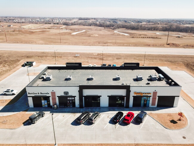
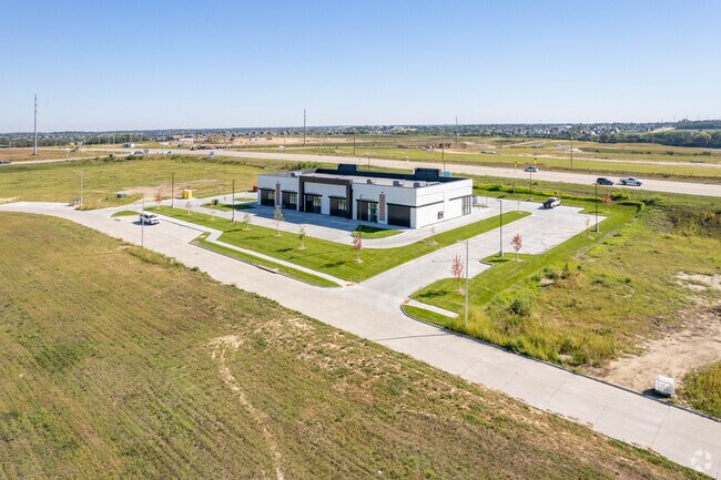
Property Record
5331 S 204Th Ave, Elkhorn, NE 68022


Current Lease Availabilities
Property Detail
5331 S 204Th Ave
Omaha, NE-IA
COVENTRY NORTH REPLAT ONE LOT 7 BLOCK 0 LOT 7 77,531 SQ FT
0063-0200-09
Douglas
Regionalshoppingcenterormallwithanchorstore
Nebraska
B and X Area of moderate flood hazard, usually the area between the limits of the 100-year and 500-year floods.
7
2024
1.78 AC
2025
Southwest Omaha
007509
Omaha/Council Bluffs
10,075 SF
NEARBY LISTINGS FOR SALE OR LEASE
-
-
View all Elkhorn listings for lease on LoopNet.com
DEMOGRAPHICS near 5331 S 204Th Ave
1 mile
3 mile
5 mile
2025 Total Population
7,788
50,213
130,600
2030 Population
8,433
53,052
136,818
Pop Growth 2025-2030
+ 8.28%
+ 5.65%
+ 4.76%
Average Age
35
36
38
2025 Total Households
2,571
16,377
45,787
HH Growth 2025-2030
+ 8.40%
+ 5.78%
+ 4.81%
Median Household Inc
$131,713
$148,974
$128,042
Avg Household Size
3.00
3.00
2.80
2025 Avg HH Vehicles
2.00
2.00
2.00
Median Home Value
$420,330
$414,566
$380,785
Median Year Built
2010
2008
2003
Nearby Places
Map Layers
Map Styles
 Street
 Aerial
Layers
 Traffic
 Biking
Places
Listings with unknown addresses are not visible on the map
- Restaurants
- Banks
- Shops
- Fitness
- Groceries
PUBLIC TRANSPORTATION
AIRPORT
Eppley Airfield
Drive
Walk
Distance
Eppley Airfield
41 min
24.4 mi
Lincoln
Drive
Walk
Distance
Lincoln
52 min
43.2 mi
Nearby Properties
Address
Land Use
TOTAL SIZE
Lot Size
Zoning
Address
Land Use
TOTAL SIZE
Lot Size
Zoning
349,722 SF
25.22 AC
R6
Address
Land Use
TOTAL SIZE
Lot Size
Zoning
391,191 SF
87.18 AC
GI
Address
Land Use
TOTAL SIZE
Lot Size
Zoning
394,017 SF
11.62 AC
Address
Land Use
TOTAL SIZE
Lot Size
Zoning
277,073 SF
16.78 AC
Address
Land Use
TOTAL SIZE
Lot Size
Zoning
299,172 SF
13.80 AC
R7
Address
Land Use
TOTAL SIZE
Lot Size
Zoning
165,950 SF
11.57 AC
MH
Address
Land Use
TOTAL SIZE
Lot Size
Zoning
240,630 SF
5.38 AC
Address
Land Use
TOTAL SIZE
Lot Size
Zoning
257,106 SF
21.44 AC
R6
Address
Land Use
TOTAL SIZE
Lot Size
Zoning
222,090 SF
7.74 AC
R6
Address
Land Use
TOTAL SIZE
Lot Size
Zoning
193,490 SF
9.35 AC
Address
Land Use
TOTAL SIZE
Lot Size
Zoning
28,444 SF
0.85 AC
Address
Land Use
TOTAL SIZE
Lot Size
Zoning
387,400 SF
6.13 AC
Address
Land Use
TOTAL SIZE
Lot Size
Zoning
52,791 SF
8.09 AC
Address
Land Use
TOTAL SIZE
Lot Size
Zoning
209,767 SF
21.17 AC
MU
Address
Land Use
TOTAL SIZE
Lot Size
Zoning
137,181 SF
16.36 AC
MU
Address
Land Use
TOTAL SIZE
Lot Size
Zoning
134,709 SF
2.32 AC
MU
Address
Land Use
TOTAL SIZE
Lot Size
Zoning
138,942 SF
2.86 AC
Address
Land Use
TOTAL SIZE
Lot Size
Zoning
32,049 SF
5.70 AC
Address
Land Use
TOTAL SIZE
Lot Size
Zoning
107,577 SF
4.24 AC
Address
Land Use
TOTAL SIZE
Lot Size
Zoning
72,485 SF
1.75 AC
Address
Land Use
TOTAL SIZE
Lot Size
Zoning
83,022 SF
2.72 AC
MU
Address
Land Use
TOTAL SIZE
Lot Size
Zoning
39,264 SF
1.67 AC
RG35
Address
Land Use
TOTAL SIZE
Lot Size
Zoning
9,083 SF
2.56 AC
Address
Land Use
TOTAL SIZE
Lot Size
Zoning
63,580 SF
1.92 AC
Address
Land Use
TOTAL SIZE
Lot Size
Zoning
78,656 SF
8.63 AC
MU
Address
Land Use
TOTAL SIZE
Lot Size
Zoning
44,562 SF
2.37 AC
MU
Address
Land Use
TOTAL SIZE
Lot Size
Zoning
63,241 SF
3.13 AC
Address
Land Use
TOTAL SIZE
Lot Size
Zoning
2,202 SF
45.04 AC
Address
Land Use
TOTAL SIZE
Lot Size
Zoning
30,415 SF
3.26 AC
Address
Land Use
TOTAL SIZE
Lot Size
Zoning
57,700 SF
10.04 AC
The World's #1 Commercial Real Estate Marketplace
Connect with us
© 2026 CoStar Group
The information above has been obtained from sources believed reliable. While we do not doubt its accuracy we have not verified it and make no guarantee, warranty or representation about it. It is your responsibility to independently confirm its accuracy and completeness. Any projections, opinions, assumptions, or estimates used are for example only and do not represent the current or future performance of the property. The value of this transaction to you depends on tax and other factors which should be evaluated by your tax, financial, and legal advisors. You and your advisors should conduct a careful, independent investigation of the property to determine to your satisfaction the suitability of the property for your needs.