Property Record
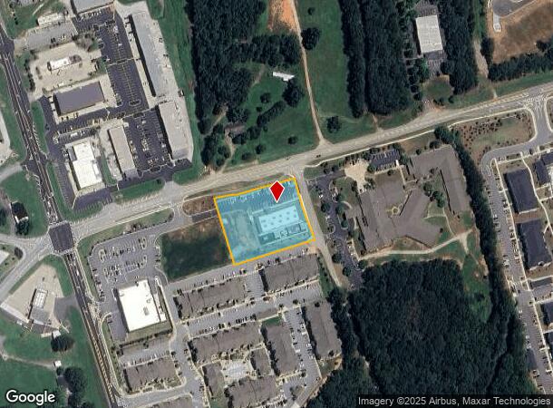
5331 Thompson Mill Rd, Hoschton, GA 30548

NEARBY LISTINGS FOR SALE OR LEASE
Property Detail
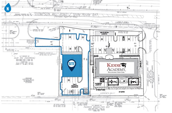
5331 Thompson Mill Rd
Gainesville, GA
Friendship/Thompson/Spout Commercial
15-00041-00-135
TRACT 3
Daycare
Hall
X
Georgia
13013C0050D
0
2025
1.60 AC
2025
Gainesville/Hall County
001611
Atlanta
10,161 SF
DEMOGRAPHICS near 5331 Thompson Mill Rd
1 Mile
3 Mile
5 Mile
2024 Total Population
4,372
38,661
94,725
2029 Population
4,788
42,121
103,853
Pop Growth 2024-2029
+ 9.52%
+ 8.95%
+ 9.64%
Average Age
39
40
39
2024 Total Households
1,385
12,717
30,732
HH Growth 2024-2029
+ 9.60%
+ 9.21%
+ 9.84%
Median Household Inc
$126,760
$113,344
$109,943
Avg Household Size
3.10
3.00
3.00
2024 Avg HH Vehicles
2.00
2.00
2.00
Median Home Value
$386,569
$365,563
$349,761
Median Year Built
2006
2005
2004
Nearby Places
Map Layers
Map Styles
 Street
 Aerial
- Restaurants
- Banks
- Shops
- Fitness
- Groceries
SALE & LEASE HISTORY
LISTING DATE
SALE/LEASE

Sep 24, 2016
For Sale
Jun 26, 2017
For Sale
Feb 27, 2025
For Sale
Aug 29, 2018
For Sale
Apr 13, 2017
For Sale
Nearby Properties
Address
Land Use
TOTAL SIZE
Lot Size
Zoning
Address
Land Use
TOTAL SIZE
Lot Size
Zoning
105,000 SF
104.18 AC
POD
Address
Land Use
TOTAL SIZE
Lot Size
Zoning
379,680 SF
76.71 AC
R100
Address
Land Use
TOTAL SIZE
Lot Size
Zoning
372,813 SF
172.70 AC
RA200
Address
Land Use
TOTAL SIZE
Lot Size
Zoning
404,091 SF
58.20 AC
RA200
Address
Land Use
TOTAL SIZE
Lot Size
Zoning
30,720 SF
12.28 AC
G-C
Address
Land Use
TOTAL SIZE
Lot Size
Zoning
381,371 SF
77.30 AC
PUD
Address
Land Use
TOTAL SIZE
Lot Size
Zoning
263,400 SF
8.65 AC
PRD
Address
Land Use
TOTAL SIZE
Lot Size
Zoning
114,835 SF
15.29 AC
POD
Address
Land Use
TOTAL SIZE
Lot Size
Zoning
46,400 SF
3.51 AC
G-C
Address
Land Use
TOTAL SIZE
Lot Size
Zoning
44,824 SF
3.22 AC
G-C
Address
Land Use
TOTAL SIZE
Lot Size
Zoning
42,053 SF
40.90 AC
PUD
Address
Land Use
TOTAL SIZE
Lot Size
Zoning
24,486 SF
3.85 AC
G-C
Address
Land Use
TOTAL SIZE
Lot Size
Zoning
82,604 SF
13.11 AC
G-C
Address
Land Use
TOTAL SIZE
Lot Size
Zoning
31,094 SF
126.02 AC
RA200
Address
Land Use
TOTAL SIZE
Lot Size
Zoning
71,951 SF
8.78 AC
PRD
Address
Land Use
TOTAL SIZE
Lot Size
Zoning
1,280 SF
24.21 AC
PCD
Address
Land Use
TOTAL SIZE
Lot Size
Zoning
42,848 SF
4.55 AC
G-C
Address
Land Use
TOTAL SIZE
Lot Size
Zoning
24,490 SF
8.30 AC
C2
Address
Land Use
TOTAL SIZE
Lot Size
Zoning
15,000 SF
7.53 AC
G-C
Address
Land Use
TOTAL SIZE
Lot Size
Zoning
24,290 SF
6.15 AC
PUD
Address
Land Use
TOTAL SIZE
Lot Size
Zoning
35,318 SF
6.72 AC
G-C
Address
Land Use
TOTAL SIZE
Lot Size
Zoning
94,098 SF
1.83 AC
MUNI
Address
Land Use
TOTAL SIZE
Lot Size
Zoning
17,900 SF
21.18 AC
RA200
Address
Land Use
TOTAL SIZE
Lot Size
Zoning
8,204 SF
5.25 AC
G-C
Address
Land Use
TOTAL SIZE
Lot Size
Zoning
24,500 SF
10.71 AC
RA200
Address
Land Use
TOTAL SIZE
Lot Size
Zoning
191.82 AC
PUD
Address
Land Use
TOTAL SIZE
Lot Size
Zoning
1,412 SF
43 AC
OI
Address
Land Use
TOTAL SIZE
Lot Size
Zoning
93,158 SF
2.04 AC
PRD
Address
Land Use
TOTAL SIZE
Lot Size
Zoning
29,212 SF
2.64 AC
N-C
Address
Land Use
TOTAL SIZE
Lot Size
Zoning
17,110 SF
5.73 AC
PCD
The World's #1 Commercial Real Estate Marketplace
Connect with us
© 2025 CoStar Group
The information above has been obtained from sources believed reliable. While we do not doubt its accuracy we have not verified it and make no guarantee, warranty or representation about it. It is your responsibility to independently confirm its accuracy and completeness. Any projections, opinions, assumptions, or estimates used are for example only and do not represent the current or future performance of the property. The value of this transaction to you depends on tax and other factors which should be evaluated by your tax, financial, and legal advisors. You and your advisors should conduct a careful, independent investigation of the property to determine to your satisfaction the suitability of the property for your needs.