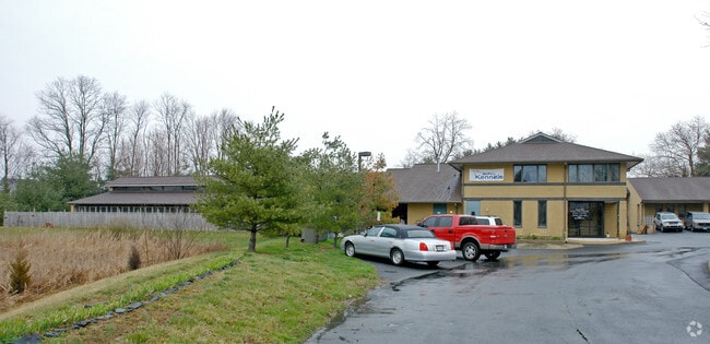
Property Record
534 E Jarrettsville Rd, Forest Hill, MD 21050


Save to a Folder
{{folder.Name}}
{{folder.ListingIds.length}} Properties
{{folder.ListingIds.length}} Property
Create a New Folder
Property Detail
534 E Jarrettsville Rd
03-087921
3.221 AC 534 E JARRETTSVILLE ROAD SENIOR BOGARTY PT 81/56
Multifamilydwelling
Harford
B3
Maryland
B and X Area of moderate flood hazard, usually the area between the limits of the 100-year and 500-year floods.
3.22 AC
2025
Outlying Harford County
2025
Baltimore
303201
Baltimore-Columbia-Towson, MD
1,296 SF
NEARBY LISTINGS FOR SALE OR LEASE
DEMOGRAPHICS near 534 E Jarrettsville Rd
1 mile
3 mile
5 mile
2025 Total Population
5,202
42,251
80,025
2030 Population
5,249
42,420
80,347
Pop Growth 2025-2030
+ 0.90%
+ 0.40%
+ 0.40%
Average Age
40
41
42
2025 Total Households
1,813
15,572
29,723
HH Growth 2025-2030
+ 0.88%
+ 0.39%
+ 0.45%
Median Household Inc
$122,298
$117,164
$119,545
Avg Household Size
2.80
2.60
2.60
2025 Avg HH Vehicles
2.00
2.00
2.00
Median Home Value
$407,649
$414,543
$438,119
Median Year Built
1994
1988
1987
Nearby Places
Map Layers
Map Styles
 Street
 Aerial
Layers
 Traffic
 Biking
Places
Listings with unknown addresses are not visible on the map
- Restaurants
- Banks
- Shops
- Fitness
- Groceries
PUBLIC TRANSPORTATION
AIRPORT
Baltimore/Washington International Thurgood Marshall
Drive
Walk
Distance
Baltimore/Washington International Thurgood Marshall
59 min
40.2 mi
Freight Ports
Port Newark Container Terminal
Drive
Walk
Distance
Port Newark Container Terminal
49 min
30.9 mi
Nearby Properties
Address
Land Use
TOTAL SIZE
Lot Size
Zoning
Address
Land Use
TOTAL SIZE
Lot Size
Zoning
51,475 SF
7.85 AC
C1
Address
Land Use
TOTAL SIZE
Lot Size
Zoning
5,674 SF
288 AC
R4
Address
Land Use
TOTAL SIZE
Lot Size
Zoning
161,723 SF
72.26 AC
R1
Address
Land Use
TOTAL SIZE
Lot Size
Zoning
228 AC
COS
Address
Land Use
TOTAL SIZE
Lot Size
Zoning
55,164 SF
16.22 AC
B2
Address
Land Use
TOTAL SIZE
Lot Size
Zoning
13.02 AC
R3
Address
Land Use
TOTAL SIZE
Lot Size
Zoning
12.38 AC
R2
Address
Land Use
TOTAL SIZE
Lot Size
Zoning
6,084 SF
6.03 AC
B2
Address
Land Use
TOTAL SIZE
Lot Size
Zoning
101,236 SF
23.52 AC
R1
Address
Land Use
TOTAL SIZE
Lot Size
Zoning
113,276 SF
2.19 AC
B2A
Address
Land Use
TOTAL SIZE
Lot Size
Zoning
78,264 SF
16.71 AC
AG
Address
Land Use
TOTAL SIZE
Lot Size
Zoning
52,245 SF
2.43 AC
R3/B1
Address
Land Use
TOTAL SIZE
Lot Size
Zoning
74,842 SF
0.77 AC
B2 B3
Address
Land Use
TOTAL SIZE
Lot Size
Zoning
10.73 AC
B2
Address
Land Use
TOTAL SIZE
Lot Size
Zoning
229,355 SF
59.83 AC
R2
Address
Land Use
TOTAL SIZE
Lot Size
Zoning
46,247 SF
10.45 AC
R2 B2
Address
Land Use
TOTAL SIZE
Lot Size
Zoning
35.99 AC
R2
Address
Land Use
TOTAL SIZE
Lot Size
Zoning
78,394 SF
24.56 AC
CI
Address
Land Use
TOTAL SIZE
Lot Size
Zoning
7,104 SF
10.95 AC
R2 R3
Address
Land Use
TOTAL SIZE
Lot Size
Zoning
77,649 SF
10.42 AC
GI
Address
Land Use
TOTAL SIZE
Lot Size
Zoning
63,392 SF
8.44 AC
VR
Address
Land Use
TOTAL SIZE
Lot Size
Zoning
9,464 SF
3.51 AC
R3
Address
Land Use
TOTAL SIZE
Lot Size
Zoning
97,060 SF
8.39 AC
B2
Address
Land Use
TOTAL SIZE
Lot Size
Zoning
51,868 SF
6.25 AC
R3
Address
Land Use
TOTAL SIZE
Lot Size
Zoning
149,009 SF
0.69 AC
B3
Address
Land Use
TOTAL SIZE
Lot Size
Zoning
17,901 SF
6.74 AC
R3
Address
Land Use
TOTAL SIZE
Lot Size
Zoning
14,948 SF
0.75 AC
B2
Address
Land Use
TOTAL SIZE
Lot Size
Zoning
19,224 SF
6.43 AC
R2
Address
Land Use
TOTAL SIZE
Lot Size
Zoning
53,964 SF
1.31 AC
R1
Address
Land Use
TOTAL SIZE
Lot Size
Zoning
84,100 SF
2.58 AC
B3
The World's #1 Commercial Real Estate Marketplace
Connect with us
© 2026 CoStar Group
The information above has been obtained from sources believed reliable. While we do not doubt its accuracy we have not verified it and make no guarantee, warranty or representation about it. It is your responsibility to independently confirm its accuracy and completeness. Any projections, opinions, assumptions, or estimates used are for example only and do not represent the current or future performance of the property. The value of this transaction to you depends on tax and other factors which should be evaluated by your tax, financial, and legal advisors. You and your advisors should conduct a careful, independent investigation of the property to determine to your satisfaction the suitability of the property for your needs.