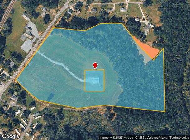
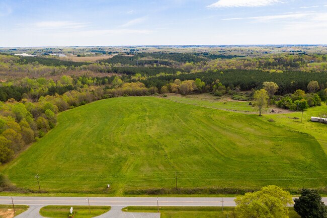
Property Record
530 E Main St, Liberty, SC 29657

NEARBY LISTINGS FOR SALE OR LEASE
-
-
View all Liberty listings for sale on LoopNet.com
Property Detail
530 E Main St
Greenville-Anderson-Mauldin, SC
Stancell Loran
4098-18-41-8772
STANCELL LORAN E/SIDE HWY 93 PLAT 322/17 LOTS 1-6, 7 PLAT 324/7
Vacantlandnec
Pickens
X
South Carolina
45007C0025E
1-7
2025
24.92 AC
2024
Outlying Pickens County
011005
Greenville/Spartanburg
DEMOGRAPHICS near 530 E Main St
1 Mile
3 Mile
5 Mile
2024 Total Population
1,974
10,456
31,319
2029 Population
2,057
10,894
32,817
Pop Growth 2024-2029
+ 4.20%
+ 4.19%
+ 4.78%
Average Age
40
40
40
2024 Total Households
808
4,082
12,303
HH Growth 2024-2029
+ 4.21%
+ 4.26%
+ 4.92%
Median Household Inc
$37,000
$44,901
$46,413
Avg Household Size
2.40
2.50
2.50
2024 Avg HH Vehicles
2.00
2.00
2.00
Median Home Value
$127,980
$144,530
$147,242
Median Year Built
1977
1986
1984
Nearby Places
Map Layers
Map Styles
 Street
 Aerial
- Restaurants
- Banks
- Shops
- Fitness
- Groceries
PUBLIC TRANSPORTATION
AIRPORT
Greenville Spartanburg International
DRIVE
WALK
Distance
Greenville Spartanburg International
51 min
33.0 mi
Freight Ports
North Charleston Terminal
DRIVE
WALK
Distance
North Charleston Terminal
255 min
219.4 mi
SALE & LEASE HISTORY
LISTING DATE
SALE/LEASE

May 23, 2017
For Sale
Apr 09, 2020
For Sale
Nearby Properties
Address
Land Use
TOTAL SIZE
Lot Size
Zoning
Address
Land Use
TOTAL SIZE
Lot Size
Zoning
133,426 SF
26.37 AC
Address
Land Use
TOTAL SIZE
Lot Size
Zoning
61,236 SF
9.42 AC
Address
Land Use
TOTAL SIZE
Lot Size
Zoning
310,714 SF
45.73 AC
Address
Land Use
TOTAL SIZE
Lot Size
Zoning
44,601 SF
3 AC
Address
Land Use
TOTAL SIZE
Lot Size
Zoning
10,000 SF
78.65 AC
Address
Land Use
TOTAL SIZE
Lot Size
Zoning
33,822 SF
19.86 AC
Address
Land Use
TOTAL SIZE
Lot Size
Zoning
21.43 AC
Address
Land Use
TOTAL SIZE
Lot Size
Zoning
14.96 AC
Address
Land Use
TOTAL SIZE
Lot Size
Zoning
239.49 AC
510
Address
Land Use
TOTAL SIZE
Lot Size
Zoning
29.37 AC
Address
Land Use
TOTAL SIZE
Lot Size
Zoning
34.59 AC
Address
Land Use
TOTAL SIZE
Lot Size
Zoning
4,957 SF
1.40 AC
508
Address
Land Use
TOTAL SIZE
Lot Size
Zoning
180.03 AC
Address
Land Use
TOTAL SIZE
Lot Size
Zoning
572 SF
21.75 AC
Address
Land Use
TOTAL SIZE
Lot Size
Zoning
54.85 AC
Address
Land Use
TOTAL SIZE
Lot Size
Zoning
15,008 SF
2.10 AC
510
Address
Land Use
TOTAL SIZE
Lot Size
Zoning
19.43 AC
Address
Land Use
TOTAL SIZE
Lot Size
Zoning
922 SF
14.30 AC
Address
Land Use
TOTAL SIZE
Lot Size
Zoning
116.77 AC
Address
Land Use
TOTAL SIZE
Lot Size
Zoning
8.56 AC
510
Address
Land Use
TOTAL SIZE
Lot Size
Zoning
4,997 SF
12 AC
Address
Land Use
TOTAL SIZE
Lot Size
Zoning
3,445 SF
6.16 AC
Address
Land Use
TOTAL SIZE
Lot Size
Zoning
14.93 AC
500
Address
Land Use
TOTAL SIZE
Lot Size
Zoning
6,876 SF
2 AC
507
Address
Land Use
TOTAL SIZE
Lot Size
Zoning
110.67 AC
501A
Address
Land Use
TOTAL SIZE
Lot Size
Zoning
4,684 SF
0.22 AC
509
Address
Land Use
TOTAL SIZE
Lot Size
Zoning
64,226 SF
23.90 AC
Address
Land Use
TOTAL SIZE
Lot Size
Zoning
79,200 SF
26.95 AC
508
The World's #1 Commercial Real Estate Marketplace
Connect with us
© 2025 CoStar Group
The information above has been obtained from sources believed reliable. While we do not doubt its accuracy we have not verified it and make no guarantee, warranty or representation about it. It is your responsibility to independently confirm its accuracy and completeness. Any projections, opinions, assumptions, or estimates used are for example only and do not represent the current or future performance of the property. The value of this transaction to you depends on tax and other factors which should be evaluated by your tax, financial, and legal advisors. You and your advisors should conduct a careful, independent investigation of the property to determine to your satisfaction the suitability of the property for your needs.