Property Record
534 N 35Th St, Morehead City, NC 28557

NEARBY LISTINGS FOR SALE OR LEASE
Property Detail
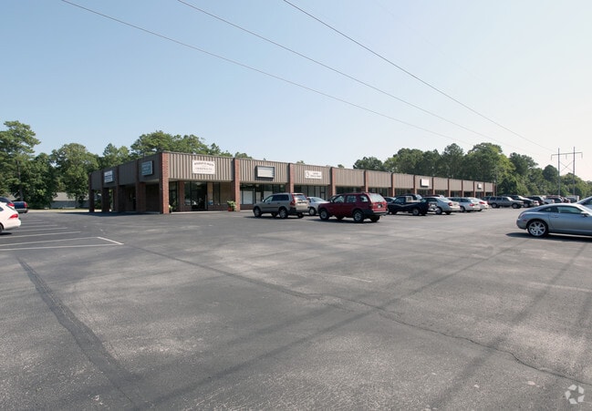
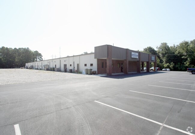
534 N 35Th St
6376.10.45.8255000
Annexation Survey For Larry D Holler
Medicalbuilding
TRACT 2 DAVID HORTON
AE
Carteret
3720637600J
North Carolina
2025
2.54 AC
2025
Other Market Areas
970503
Morehead City, NC
24,000 SF
DEMOGRAPHICS near 534 N 35Th St
1 Mile
3 Mile
5 Mile
2024 Total Population
4,150
14,377
21,327
2029 Population
4,216
15,098
22,579
Pop Growth 2024-2029
+ 1.59%
+ 5.01%
+ 5.87%
Average Age
46
47
48
2024 Total Households
2,039
6,859
10,161
HH Growth 2024-2029
+ 1.23%
+ 5.07%
+ 5.94%
Median Household Inc
$46,311
$56,145
$63,201
Avg Household Size
2.00
2.00
2.00
2024 Avg HH Vehicles
2.00
2.00
2.00
Median Home Value
$222,285
$313,544
$325,789
Median Year Built
1986
1984
1985
Nearby Places
Map Layers
Map Styles
 Street
 Aerial
- Restaurants
- Banks
- Shops
- Fitness
- Groceries
PUBLIC TRANSPORTATION
AIRPORT
Coastal Carolina Regional
DRIVE
WALK
Distance
Coastal Carolina Regional
60 min
36.5 mi
Freight Ports
Port of Morehead City
DRIVE
WALK
Distance
Port of Morehead City
8 min
3.5 mi
SALE & LEASE HISTORY
LISTING DATE
SALE/LEASE

Sep 25, 2016
For Lease
Nearby Properties
Address
Land Use
TOTAL SIZE
Lot Size
Zoning
Address
Land Use
TOTAL SIZE
Lot Size
Zoning
33,136 SF
24.01 AC
Address
Land Use
TOTAL SIZE
Lot Size
Zoning
6,696 SF
19.43 AC
Address
Land Use
TOTAL SIZE
Lot Size
Zoning
65,122 SF
7.99 AC
Address
Land Use
TOTAL SIZE
Lot Size
Zoning
3,230 SF
16.89 AC
Address
Land Use
TOTAL SIZE
Lot Size
Zoning
124,300 SF
29.34 AC
Address
Land Use
TOTAL SIZE
Lot Size
Zoning
2,464 SF
49.10 AC
Address
Land Use
TOTAL SIZE
Lot Size
Zoning
52,212 SF
17.61 AC
Address
Land Use
TOTAL SIZE
Lot Size
Zoning
92,731 SF
3.53 AC
Address
Land Use
TOTAL SIZE
Lot Size
Zoning
156,266 SF
13.19 AC
Address
Land Use
TOTAL SIZE
Lot Size
Zoning
56,174 SF
5.47 AC
Address
Land Use
TOTAL SIZE
Lot Size
Zoning
63,071 SF
31.87 AC
Address
Land Use
TOTAL SIZE
Lot Size
Zoning
43,150 SF
4.31 AC
Address
Land Use
TOTAL SIZE
Lot Size
Zoning
55,768 SF
4.79 AC
Address
Land Use
TOTAL SIZE
Lot Size
Zoning
71,844 SF
8.10 AC
Address
Land Use
TOTAL SIZE
Lot Size
Zoning
5,648 SF
7.69 AC
Address
Land Use
TOTAL SIZE
Lot Size
Zoning
71,938 SF
7.29 AC
Address
Land Use
TOTAL SIZE
Lot Size
Zoning
22,188 SF
4.76 AC
Address
Land Use
TOTAL SIZE
Lot Size
Zoning
48.21 AC
Address
Land Use
TOTAL SIZE
Lot Size
Zoning
44,796 SF
2.75 AC
Address
Land Use
TOTAL SIZE
Lot Size
Zoning
17,177 SF
1.19 AC
Address
Land Use
TOTAL SIZE
Lot Size
Zoning
1,916 SF
4.83 AC
Address
Land Use
TOTAL SIZE
Lot Size
Zoning
49,724 SF
8.81 AC
Address
Land Use
TOTAL SIZE
Lot Size
Zoning
Address
Land Use
TOTAL SIZE
Lot Size
Zoning
2,927 SF
2.29 AC
Address
Land Use
TOTAL SIZE
Lot Size
Zoning
30,337 SF
2.06 AC
Address
Land Use
TOTAL SIZE
Lot Size
Zoning
15,434 SF
1.38 AC
Address
Land Use
TOTAL SIZE
Lot Size
Zoning
15,786 SF
1.90 AC
Address
Land Use
TOTAL SIZE
Lot Size
Zoning
35,462 SF
3.13 AC
Address
Land Use
TOTAL SIZE
Lot Size
Zoning
91,056 SF
6.77 AC
Address
Land Use
TOTAL SIZE
Lot Size
Zoning
48,528 SF
1.72 AC
The World's #1 Commercial Real Estate Marketplace
Connect with us
© 2026 CoStar Group
The information above has been obtained from sources believed reliable. While we do not doubt its accuracy we have not verified it and make no guarantee, warranty or representation about it. It is your responsibility to independently confirm its accuracy and completeness. Any projections, opinions, assumptions, or estimates used are for example only and do not represent the current or future performance of the property. The value of this transaction to you depends on tax and other factors which should be evaluated by your tax, financial, and legal advisors. You and your advisors should conduct a careful, independent investigation of the property to determine to your satisfaction the suitability of the property for your needs.