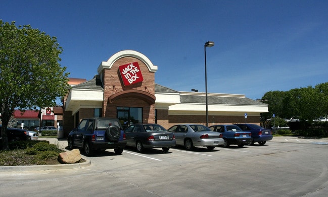
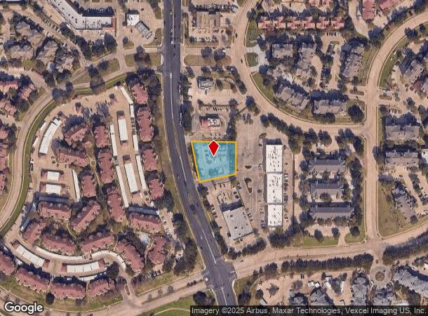
Property Record
5340 N Macarthur Blvd, Irving, TX 75038
NEARBY LISTINGS FOR SALE OR LEASE
Property Detail
5340 N Macarthur Blvd
Dallas-Fort Worth-Arlington, TX
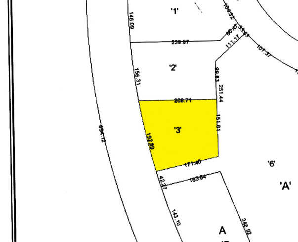
Las Colinas Sec 30 3Rd Inst
322592200A0030000
LAS COLINAS SEC 30 3RD INST BLK A LT 3 ACS 0.750 CALC INT200600242294 DD06282006 CO-DC 2592200A00300 1CI2592200A
Restaurantdrivein
Dallas
X
Texas
48113C0165K
3
2024
0.75 AC
2025
Irving
014313
Dallas/Ft Worth
2,998 SF
DEMOGRAPHICS near 5340 N Macarthur Blvd
1 Mile
3 Mile
5 Mile
2024 Total Population
11,323
112,615
236,728
2029 Population
11,191
111,793
235,954
Pop Growth 2024-2029
(1.17%)
(0.73%)
(0.33%)
Average Age
30
34
34
2024 Total Households
4,431
46,809
91,917
HH Growth 2024-2029
(1.42%)
(0.66%)
(0.51%)
Median Household Inc
$90,699
$83,298
$73,391
Avg Household Size
2.50
2.40
2.50
2024 Avg HH Vehicles
1.00
2.00
2.00
Median Home Value
$708,333
$366,718
$295,404
Median Year Built
1990
1992
1989
Nearby Places
Map Layers
Map Styles
 Street
 Aerial
- Restaurants
- Banks
- Shops
- Fitness
- Groceries
PUBLIC TRANSPORTATION
TRANSIT/SUBWAY
Hidden Ridge Station (DART LIGHT RAIL - GREEN LINE - Dallas Area Rapid Transit (DART), DART LIGHT RAIL - ORANGE LINE - Dallas Area Rapid Transit (DART))
DRIVE
WALK
Distance
Hidden Ridge Station (DART LIGHT RAIL - GREEN LINE - Dallas Area Rapid Transit (DART), DART LIGHT RAIL - ORANGE LINE - Dallas Area Rapid Transit (DART))
2 min
11 min
0.6 mi
North Lake College (DART LIGHT RAIL - ORANGE LINE - Dallas Area Rapid Transit (DART), Orange Line - Dallas Area Rapid Transit (DART))
DRIVE
WALK
Distance
North Lake College (DART LIGHT RAIL - ORANGE LINE - Dallas Area Rapid Transit (DART), Orange Line - Dallas Area Rapid Transit (DART))
2 min
16 min
0.8 mi
COMMUTER RAIL
Downtown Irving/Heritage Crossing Station (TRINITY RAILWAY - Dallas Area Rapid Transit (DART), Trinity Railway Express - Dallas Area Rapid Transit (DART))
DRIVE
WALK
Distance
Downtown Irving/Heritage Crossing Station (TRINITY RAILWAY - Dallas Area Rapid Transit (DART), Trinity Railway Express - Dallas Area Rapid Transit (DART))
13 min
5.3 mi
West Irving (TRINITY RAILWAY - Dallas Area Rapid Transit (DART), Trinity Railway Express - Dallas Area Rapid Transit (DART))
DRIVE
WALK
Distance
West Irving (TRINITY RAILWAY - Dallas Area Rapid Transit (DART), Trinity Railway Express - Dallas Area Rapid Transit (DART))
14 min
8.6 mi
AIRPORT
Dallas-Fort Worth International
DRIVE
WALK
Distance
Dallas-Fort Worth International
15 min
9.4 mi
Dallas Love Field
DRIVE
WALK
Distance
Dallas Love Field
19 min
11.2 mi
Freight Ports
Port of Shreveport
DRIVE
WALK
Distance
Port of Shreveport
229 min
210.4 mi
Nearby Properties
Address
Land Use
TOTAL SIZE
Lot Size
Zoning
Address
Land Use
TOTAL SIZE
Lot Size
Zoning
1,066,464 SF
4.10 AC
Z392
Address
Land Use
TOTAL SIZE
Lot Size
Zoning
2,496,382 SF
256.13 AC
Z392
Address
Land Use
TOTAL SIZE
Lot Size
Zoning
962,320 SF
23.81 AC
Z198
Address
Land Use
TOTAL SIZE
Lot Size
Zoning
1,520,000 SF
34.76 AC
Z243
Address
Land Use
TOTAL SIZE
Lot Size
Zoning
850,390 SF
16.12 AC
Address
Land Use
TOTAL SIZE
Lot Size
Zoning
565,728 SF
21.07 AC
Address
Land Use
TOTAL SIZE
Lot Size
Zoning
346,000 SF
15.52 AC
Z198
Address
Land Use
TOTAL SIZE
Lot Size
Zoning
1,673,367 SF
17.29 AC
Z243
Address
Land Use
TOTAL SIZE
Lot Size
Zoning
1,763,184 SF
11.25 AC
Z393
Address
Land Use
TOTAL SIZE
Lot Size
Zoning
379,000 SF
9.81 AC
Z243
Address
Land Use
TOTAL SIZE
Lot Size
Zoning
674,817 SF
15.35 AC
Z84
Address
Land Use
TOTAL SIZE
Lot Size
Zoning
631,947 SF
11.95 AC
Z393
Address
Land Use
TOTAL SIZE
Lot Size
Zoning
470,764 SF
13.85 AC
Z236
Address
Land Use
TOTAL SIZE
Lot Size
Zoning
689,004 SF
25.23 AC
Z243
Address
Land Use
TOTAL SIZE
Lot Size
Zoning
654,829 SF
9.78 AC
Z243
Address
Land Use
TOTAL SIZE
Lot Size
Zoning
735,258 SF
4.83 AC
Z392
Address
Land Use
TOTAL SIZE
Lot Size
Zoning
471,524 SF
20.34 AC
Z84
Address
Land Use
TOTAL SIZE
Lot Size
Zoning
1,144,971 SF
19.43 AC
Z84
Address
Land Use
TOTAL SIZE
Lot Size
Zoning
729,870 SF
24.42 AC
Z393
Address
Land Use
TOTAL SIZE
Lot Size
Zoning
608,308 SF
7.26 AC
Z198
Address
Land Use
TOTAL SIZE
Lot Size
Zoning
550,411 SF
19.39 AC
Z243
Address
Land Use
TOTAL SIZE
Lot Size
Zoning
464,996 SF
18.43 AC
SP2
Address
Land Use
TOTAL SIZE
Lot Size
Zoning
671,349 SF
5.31 AC
Z243
Address
Land Use
TOTAL SIZE
Lot Size
Zoning
371,837 SF
54.36 AC
Z86
Address
Land Use
TOTAL SIZE
Lot Size
Zoning
724,643 SF
5.15 AC
Z243
Address
Land Use
TOTAL SIZE
Lot Size
Zoning
347,008 SF
9.54 AC
Z57
Address
Land Use
TOTAL SIZE
Lot Size
Zoning
1,219,380 SF
16.01 AC
Z243
Address
Land Use
TOTAL SIZE
Lot Size
Zoning
457,322 SF
22.98 AC
Z243
Address
Land Use
TOTAL SIZE
Lot Size
Zoning
543,965 SF
8.02 AC
Z323
Address
Land Use
TOTAL SIZE
Lot Size
Zoning
717,650 SF
28.32 AC
Z243
The World's #1 Commercial Real Estate Marketplace
Connect with us
© 2026 CoStar Group
The information above has been obtained from sources believed reliable. While we do not doubt its accuracy we have not verified it and make no guarantee, warranty or representation about it. It is your responsibility to independently confirm its accuracy and completeness. Any projections, opinions, assumptions, or estimates used are for example only and do not represent the current or future performance of the property. The value of this transaction to you depends on tax and other factors which should be evaluated by your tax, financial, and legal advisors. You and your advisors should conduct a careful, independent investigation of the property to determine to your satisfaction the suitability of the property for your needs.