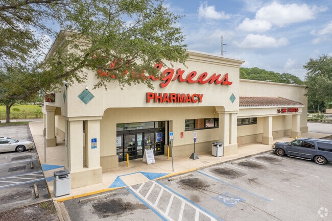
Property Record
5340 Soutel Dr, Jacksonville, FL 32219


Current Lease Availabilities
NEARBY LISTINGS FOR SALE OR LEASE
Property Detail
5340 Soutel Dr
022232-0100
Section Land
Medicalbuilding
29-1S-26E 1.80 PT SECS 29,39 RECD O/R 19580-2
X
Duval
12031C0188J
Florida
2024
1.79 AC
2025
Northwest Jacksonville
010700
Jacksonville (Florida)
15,400 SF
Jacksonville, FL
DEMOGRAPHICS near 5340 Soutel Dr
1 Mile
3 Mile
5 Mile
2024 Total Population
8,430
47,677
133,480
2029 Population
8,905
50,257
141,404
Pop Growth 2024-2029
+ 5.63%
+ 5.41%
+ 5.94%
Average Age
42
40
39
2024 Total Households
3,328
18,072
51,148
HH Growth 2024-2029
+ 5.74%
+ 5.52%
+ 6.05%
Median Household Inc
$44,774
$42,949
$37,691
Avg Household Size
2.50
2.60
2.50
2024 Avg HH Vehicles
1.00
2.00
1.00
Median Home Value
$136,115
$132,830
$133,540
Median Year Built
1967
1967
1967
Nearby Places
Map Layers
Map Styles
 Street
 Aerial
- Restaurants
- Banks
- Shops
- Fitness
- Groceries
PUBLIC TRANSPORTATION
COMMUTER RAIL
Jacksonville (Silver Meteor - Amtrak, Silver Star - Amtrak)
DRIVE
WALK
Distance
Jacksonville (Silver Meteor - Amtrak, Silver Star - Amtrak)
5 min
2.2 mi
AIRPORT
Jacksonville International
DRIVE
WALK
Distance
Jacksonville International
20 min
11.6 mi
Freight Ports
Jacksonville Port
DRIVE
WALK
Distance
Jacksonville Port
15 min
7.7 mi
Nearby Properties
Address
Land Use
TOTAL SIZE
Lot Size
Zoning
Address
Land Use
TOTAL SIZE
Lot Size
Zoning
449,967 SF
23.08 AC
IL
Address
Land Use
TOTAL SIZE
Lot Size
Zoning
262,792 SF
15.23 AC
PUD
Address
Land Use
TOTAL SIZE
Lot Size
Zoning
299,588 SF
75.26 AC
IBP
Address
Land Use
TOTAL SIZE
Lot Size
Zoning
302,066 SF
15.70 AC
IL
Address
Land Use
TOTAL SIZE
Lot Size
Zoning
277,582 SF
16.49 AC
IL
Address
Land Use
TOTAL SIZE
Lot Size
Zoning
240,050 SF
28.53 AC
IBP
Address
Land Use
TOTAL SIZE
Lot Size
Zoning
317,474 SF
17.74 AC
IL
Address
Land Use
TOTAL SIZE
Lot Size
Zoning
249,082 SF
31.28 AC
PUD
Address
Land Use
TOTAL SIZE
Lot Size
Zoning
255,048 SF
20.15 AC
IL
Address
Land Use
TOTAL SIZE
Lot Size
Zoning
171,572 SF
10.47 AC
PUD
Address
Land Use
TOTAL SIZE
Lot Size
Zoning
225,829 SF
140.47 AC
PBF-1
Address
Land Use
TOTAL SIZE
Lot Size
Zoning
189,832 SF
13.08 AC
PUD
Address
Land Use
TOTAL SIZE
Lot Size
Zoning
296,575 SF
16.24 AC
PUD
Address
Land Use
TOTAL SIZE
Lot Size
Zoning
178,080 SF
9.34 AC
IL
Address
Land Use
TOTAL SIZE
Lot Size
Zoning
157,948 SF
9.22 AC
PUD
Address
Land Use
TOTAL SIZE
Lot Size
Zoning
190,264 SF
14.62 AC
RMD-D
Address
Land Use
TOTAL SIZE
Lot Size
Zoning
80,622 SF
78.47 AC
PUD
Address
Land Use
TOTAL SIZE
Lot Size
Zoning
392,885 SF
61.13 AC
PBF-1
Address
Land Use
TOTAL SIZE
Lot Size
Zoning
95,080 SF
9.35 AC
CRO
Address
Land Use
TOTAL SIZE
Lot Size
Zoning
120,586 SF
36.53 AC
IL
Address
Land Use
TOTAL SIZE
Lot Size
Zoning
85,326 SF
26.76 AC
PUD
Address
Land Use
TOTAL SIZE
Lot Size
Zoning
130,104 SF
19.95 AC
IBP
Address
Land Use
TOTAL SIZE
Lot Size
Zoning
337,531 SF
22.07 AC
IL
Address
Land Use
TOTAL SIZE
Lot Size
Zoning
142,998 SF
7.07 AC
PUD
Address
Land Use
TOTAL SIZE
Lot Size
Zoning
157,948 SF
9.02 AC
PUD
Address
Land Use
TOTAL SIZE
Lot Size
Zoning
220,152 SF
11.99 AC
IL
Address
Land Use
TOTAL SIZE
Lot Size
Zoning
1,688 SF
99.78 AC
IH
Address
Land Use
TOTAL SIZE
Lot Size
Zoning
74,790 SF
10.24 AC
RMD-C
Address
Land Use
TOTAL SIZE
Lot Size
Zoning
153,000 SF
25.53 AC
PBF-1
Address
Land Use
TOTAL SIZE
Lot Size
Zoning
122,467 SF
9.89 AC
IH
The World's #1 Commercial Real Estate Marketplace
Connect with us
© 2025 CoStar Group
The information above has been obtained from sources believed reliable. While we do not doubt its accuracy we have not verified it and make no guarantee, warranty or representation about it. It is your responsibility to independently confirm its accuracy and completeness. Any projections, opinions, assumptions, or estimates used are for example only and do not represent the current or future performance of the property. The value of this transaction to you depends on tax and other factors which should be evaluated by your tax, financial, and legal advisors. You and your advisors should conduct a careful, independent investigation of the property to determine to your satisfaction the suitability of the property for your needs.