Property Record
5345 Bbs Way, Braselton, GA 30517
NEARBY LISTINGS FOR SALE OR LEASE
Property Detail
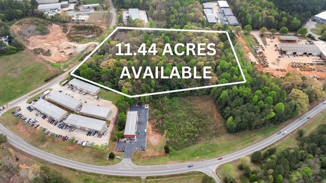
5345 Bbs Way
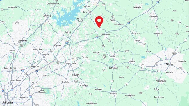
Gainesville, GA
Mulberry Ridge
15-0028F-00-018
RACEWAY-TECHNLGY PK LT 19
Industrialacreage
Hall
X
Georgia
13013C0025D
19
2025
6.14 AC
2025
Gainesville/Hall County
001603
Atlanta
DEMOGRAPHICS near 5345 Bbs Way
1 Mile
3 Mile
5 Mile
2024 Total Population
1,231
18,691
50,350
2029 Population
1,383
21,755
57,986
Pop Growth 2024-2029
+ 12.35%
+ 16.39%
+ 15.17%
Average Age
39
40
40
2024 Total Households
406
6,431
17,179
HH Growth 2024-2029
+ 12.07%
+ 15.53%
+ 14.70%
Median Household Inc
$75,877
$93,031
$89,553
Avg Household Size
3.00
2.90
2.90
2024 Avg HH Vehicles
2.00
2.00
2.00
Median Home Value
$283,630
$314,771
$323,761
Median Year Built
2002
2004
2004
Nearby Places
Map Layers
Map Styles
 Street
 Aerial
- Restaurants
- Banks
- Shops
- Fitness
- Groceries
SALE & LEASE HISTORY
LISTING DATE
SALE/LEASE

Nov 06, 2023
For Sale
Jul 24, 2017
For Sale
Apr 23, 2024
For Sale
Apr 17, 2018
For Sale
Apr 07, 2021
For Sale
Nearby Properties
Address
Land Use
TOTAL SIZE
Lot Size
Zoning
Address
Land Use
TOTAL SIZE
Lot Size
Zoning
105,000 SF
104.18 AC
POD
Address
Land Use
TOTAL SIZE
Lot Size
Zoning
341,330 SF
71.15 AC
001
Address
Land Use
TOTAL SIZE
Lot Size
Zoning
510,720 SF
48.46 AC
M1
Address
Land Use
TOTAL SIZE
Lot Size
Zoning
348,990 SF
86.93 AC
M
Address
Land Use
TOTAL SIZE
Lot Size
Zoning
46,400 SF
3.51 AC
G-C
Address
Land Use
TOTAL SIZE
Lot Size
Zoning
110,886 SF
34.34 AC
POD
Address
Land Use
TOTAL SIZE
Lot Size
Zoning
547,250 SF
47.51 AC
M1
Address
Land Use
TOTAL SIZE
Lot Size
Zoning
9,800 SF
681.58 AC
PCD
Address
Land Use
TOTAL SIZE
Lot Size
Zoning
44,824 SF
3.22 AC
G-C
Address
Land Use
TOTAL SIZE
Lot Size
Zoning
24,486 SF
3.85 AC
G-C
Address
Land Use
TOTAL SIZE
Lot Size
Zoning
18,510 SF
490.78 AC
PRD/PCD
Address
Land Use
TOTAL SIZE
Lot Size
Zoning
42,848 SF
4.55 AC
G-C
Address
Land Use
TOTAL SIZE
Lot Size
Zoning
24,290 SF
6.15 AC
PUD
Address
Land Use
TOTAL SIZE
Lot Size
Zoning
29,212 SF
2.64 AC
N-C
Address
Land Use
TOTAL SIZE
Lot Size
Zoning
22.22 AC
OI
Address
Land Use
TOTAL SIZE
Lot Size
Zoning
31,040 SF
3.68 AC
PUD
Address
Land Use
TOTAL SIZE
Lot Size
Zoning
7.60 AC
AR-1
Address
Land Use
TOTAL SIZE
Lot Size
Zoning
4.81 AC
AR-1
Address
Land Use
TOTAL SIZE
Lot Size
Zoning
21.83 AC
PUD
Address
Land Use
TOTAL SIZE
Lot Size
Zoning
12,243 SF
1.91 AC
G-C
Address
Land Use
TOTAL SIZE
Lot Size
Zoning
24,800 SF
2.57 AC
PUD
Address
Land Use
TOTAL SIZE
Lot Size
Zoning
59,160 SF
19.72 AC
I-2
Address
Land Use
TOTAL SIZE
Lot Size
Zoning
7,500 SF
5 AC
I-2
Address
Land Use
TOTAL SIZE
Lot Size
Zoning
14,710 SF
1.43 AC
PUD
Address
Land Use
TOTAL SIZE
Lot Size
Zoning
42,848 SF
14.84 AC
G-C
Address
Land Use
TOTAL SIZE
Lot Size
Zoning
8,902 SF
1.44 AC
G-C
Address
Land Use
TOTAL SIZE
Lot Size
Zoning
213.50 AC
AR-1
Address
Land Use
TOTAL SIZE
Lot Size
Zoning
10,060 SF
2.07 AC
G-C
Address
Land Use
TOTAL SIZE
Lot Size
Zoning
279.02 AC
AR-1
Address
Land Use
TOTAL SIZE
Lot Size
Zoning
4,539 SF
1.25 AC
G-C
The World's #1 Commercial Real Estate Marketplace
Connect with us
© 2025 CoStar Group
The information above has been obtained from sources believed reliable. While we do not doubt its accuracy we have not verified it and make no guarantee, warranty or representation about it. It is your responsibility to independently confirm its accuracy and completeness. Any projections, opinions, assumptions, or estimates used are for example only and do not represent the current or future performance of the property. The value of this transaction to you depends on tax and other factors which should be evaluated by your tax, financial, and legal advisors. You and your advisors should conduct a careful, independent investigation of the property to determine to your satisfaction the suitability of the property for your needs.