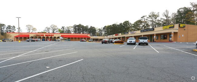
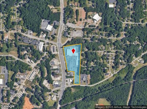
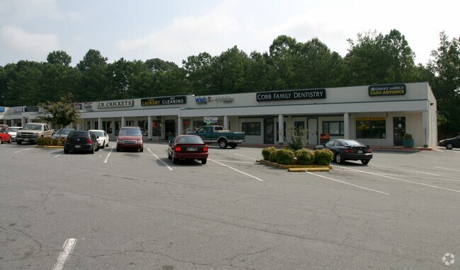
Property Record
5345 Floyd Rd Sw, Mableton, GA 30126

NEARBY LISTINGS FOR SALE OR LEASE
Property Detail
5345 Floyd Rd Sw
17-0039-0-059-0
Not Shown
Regionalshoppingcenterormallwithanchorstore
Cobb
X
Georgia
13067C0204G
806
2025
7.85 AC
2025
Powder Spring/Austell
031324
Atlanta
62,588 SF
Atlanta-Sandy Springs-Roswell, GA
DEMOGRAPHICS near 5345 Floyd Rd Sw
1 Mile
3 Mile
5 Mile
2024 Total Population
5,628
59,769
168,148
2029 Population
5,767
60,665
171,374
Pop Growth 2024-2029
+ 2.47%
+ 1.50%
+ 1.92%
Average Age
39
39
38
2024 Total Households
2,021
22,071
64,228
HH Growth 2024-2029
+ 2.42%
+ 1.45%
+ 1.88%
Median Household Inc
$73,547
$79,962
$74,348
Avg Household Size
2.60
2.60
2.50
2024 Avg HH Vehicles
2.00
2.00
2.00
Median Home Value
$272,755
$277,289
$289,283
Median Year Built
1972
1983
1987
Nearby Places
Map Layers
Map Styles
 Street
 Aerial
- Restaurants
- Banks
- Shops
- Fitness
- Groceries
PUBLIC TRANSPORTATION
AIRPORT
Hartsfield - Jackson Atlanta International
DRIVE
WALK
Distance
Hartsfield - Jackson Atlanta International
36 min
23.5 mi
Freight Ports
Georgia Ports - Savannah
DRIVE
WALK
Distance
Georgia Ports - Savannah
298 min
260.8 mi
SALE & LEASE HISTORY
LISTING DATE
SALE/LEASE

Sep 24, 2016
For Sale
Mar 24, 2017
For Lease
Feb 07, 2017
For Lease
Nearby Properties
Address
Land Use
TOTAL SIZE
Lot Size
Zoning
Address
Land Use
TOTAL SIZE
Lot Size
Zoning
494,972 SF
25.60 AC
CF
Address
Land Use
TOTAL SIZE
Lot Size
Zoning
403,898 SF
37.53 AC
RM-12
Address
Land Use
TOTAL SIZE
Lot Size
Zoning
25,956 SF
12.78 AC
PVC
Address
Land Use
TOTAL SIZE
Lot Size
Zoning
272,170 SF
26.40 AC
RM-12
Address
Land Use
TOTAL SIZE
Lot Size
Zoning
151,436 SF
11.42 AC
RM-12
Address
Land Use
TOTAL SIZE
Lot Size
Zoning
118,069 SF
0.38 AC
OI
Address
Land Use
TOTAL SIZE
Lot Size
Zoning
3.46 AC
RM-12
Address
Land Use
TOTAL SIZE
Lot Size
Zoning
111,246 SF
11.28 AC
RM-12
Address
Land Use
TOTAL SIZE
Lot Size
Zoning
121,625 SF
10.40 AC
RM-12
Address
Land Use
TOTAL SIZE
Lot Size
Zoning
198,052 SF
24.52 AC
NRC/CRC
Address
Land Use
TOTAL SIZE
Lot Size
Zoning
109,072 SF
15.23 AC
NRC
Address
Land Use
TOTAL SIZE
Lot Size
Zoning
83,314 SF
15.74 AC
NRC
Address
Land Use
TOTAL SIZE
Lot Size
Zoning
98,574 SF
10.27 AC
CRC
Address
Land Use
TOTAL SIZE
Lot Size
Zoning
113,244 SF
7.95 AC
RM-12
Address
Land Use
TOTAL SIZE
Lot Size
Zoning
115,380 SF
10.12 AC
RM-12
Address
Land Use
TOTAL SIZE
Lot Size
Zoning
89,686 SF
10.60 AC
NRC
Address
Land Use
TOTAL SIZE
Lot Size
Zoning
117,715 SF
7.88 AC
RM-12
Address
Land Use
TOTAL SIZE
Lot Size
Zoning
63,424 SF
10.67 AC
RM-12
Address
Land Use
TOTAL SIZE
Lot Size
Zoning
2.76 AC
NRC
Address
Land Use
TOTAL SIZE
Lot Size
Zoning
134,592 SF
13.43 AC
CBD
Address
Land Use
TOTAL SIZE
Lot Size
Zoning
2,636 SF
2.97 AC
NRC
Address
Land Use
TOTAL SIZE
Lot Size
Zoning
52,250 SF
7.41 AC
OS/WS
Address
Land Use
TOTAL SIZE
Lot Size
Zoning
132,312 SF
11.88 AC
RM-12
Address
Land Use
TOTAL SIZE
Lot Size
Zoning
175,923 SF
12.75 AC
GC
Address
Land Use
TOTAL SIZE
Lot Size
Zoning
94,074 SF
5 AC
PSC
Address
Land Use
TOTAL SIZE
Lot Size
Zoning
122,323 SF
9.39 AC
CRC/WS
Address
Land Use
TOTAL SIZE
Lot Size
Zoning
105,824 SF
14.92 AC
CRC
Address
Land Use
TOTAL SIZE
Lot Size
Zoning
60,630 SF
6.78 AC
CRC/WS
Address
Land Use
TOTAL SIZE
Lot Size
Zoning
1.02 AC
NRC
Address
Land Use
TOTAL SIZE
Lot Size
Zoning
2.34 AC
RM-12
The World's #1 Commercial Real Estate Marketplace
Connect with us
© 2025 CoStar Group
The information above has been obtained from sources believed reliable. While we do not doubt its accuracy we have not verified it and make no guarantee, warranty or representation about it. It is your responsibility to independently confirm its accuracy and completeness. Any projections, opinions, assumptions, or estimates used are for example only and do not represent the current or future performance of the property. The value of this transaction to you depends on tax and other factors which should be evaluated by your tax, financial, and legal advisors. You and your advisors should conduct a careful, independent investigation of the property to determine to your satisfaction the suitability of the property for your needs.