Property Record
5345 W River Rd, Waunakee, WI 53597


Save to a Folder
{{folder.Name}}
{{folder.ListingIds.length}} Properties
{{folder.ListingIds.length}} Property
Create a New Folder
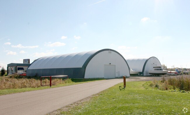
Property Detail
5345 W River Rd
Madison, WI
LOT 1 CSM 1211 CS5/113&114-7/20/73 F/K/A PRT LOT 2 CSM 334 CS2/90-3/26/69 DESCR AS SEC 22-8-9 PRT E1/2 (5.002 ACRES)
0809-221-9710-2
Dane
Commercialnec
Wisconsin
ETZ
1,2
B and X Area of moderate flood hazard, usually the area between the limits of the 100-year and 500-year floods.
5 AC
2025
Outlying Dane West
2025
Milwaukee/Madison
011201
NEARBY LISTINGS FOR SALE OR LEASE
-
-
View all Waunakee listings for sale on LoopNet.com
DEMOGRAPHICS near 5345 W River Rd
1 mile
3 mile
5 mile
2025 Total Population
2,213
23,183
58,268
2030 Population
2,290
23,956
60,540
Pop Growth 2025-2030
+ 3.48%
+ 3.33%
+ 3.90%
Average Age
47
42
41
2025 Total Households
908
9,298
25,113
HH Growth 2025-2030
+ 3.52%
+ 3.57%
+ 4.14%
Median Household Inc
$75,769
$92,849
$81,360
Avg Household Size
2.20
2.40
2.20
2025 Avg HH Vehicles
2.00
2.00
2.00
Median Home Value
$358,333
$375,790
$373,895
Median Year Built
1993
1982
1979
Nearby Places
Map Layers
Map Styles
 Street
 Aerial
Layers
 Traffic
 Biking
Places
Listings with unknown addresses are not visible on the map
- Restaurants
- Banks
- Shops
- Fitness
- Groceries
PUBLIC TRANSPORTATION
AIRPORT
Dane County Regional/Truax Field
Drive
Walk
Distance
Dane County Regional/Truax Field
8 min
4.4 mi
Freight Ports
Port Milwaukee
Drive
Walk
Distance
Port Milwaukee
97 min
81.4 mi
SALE & LEASE HISTORY
LISTING DATE
SALE/LEASE

Sep 23, 2016
For Sale
Nearby Properties
Address
Land Use
TOTAL SIZE
Lot Size
Zoning
Address
Land Use
TOTAL SIZE
Lot Size
Zoning
14.13 AC
Address
Land Use
TOTAL SIZE
Lot Size
Zoning
3.54 AC
Address
Land Use
TOTAL SIZE
Lot Size
Zoning
13.94 AC
Address
Land Use
TOTAL SIZE
Lot Size
Zoning
47.35 AC
Address
Land Use
TOTAL SIZE
Lot Size
Zoning
Address
Land Use
TOTAL SIZE
Lot Size
Zoning
2.24 AC
Address
Land Use
TOTAL SIZE
Lot Size
Zoning
14.30 AC
Address
Land Use
TOTAL SIZE
Lot Size
Zoning
Address
Land Use
TOTAL SIZE
Lot Size
Zoning
63,203 SF
1.47 AC
CC-T
Address
Land Use
TOTAL SIZE
Lot Size
Zoning
78,155 SF
8 AC
PD
Address
Land Use
TOTAL SIZE
Lot Size
Zoning
1.73 AC
Address
Land Use
TOTAL SIZE
Lot Size
Zoning
27.60 AC
ETZ
Address
Land Use
TOTAL SIZE
Lot Size
Zoning
6.23 AC
Address
Land Use
TOTAL SIZE
Lot Size
Zoning
56,813 SF
1.77 AC
CC-T
Address
Land Use
TOTAL SIZE
Lot Size
Zoning
37.33 AC
ETZ
Address
Land Use
TOTAL SIZE
Lot Size
Zoning
115,424 SF
7.13 AC
SR-V2
Address
Land Use
TOTAL SIZE
Lot Size
Zoning
Address
Land Use
TOTAL SIZE
Lot Size
Zoning
45,410 SF
2.54 AC
PD
Address
Land Use
TOTAL SIZE
Lot Size
Zoning
117,173 SF
7.87 AC
SR-V2
Address
Land Use
TOTAL SIZE
Lot Size
Zoning
4.56 AC
R-4
Address
Land Use
TOTAL SIZE
Lot Size
Zoning
49,234 SF
1.46 AC
SR-V2
Address
Land Use
TOTAL SIZE
Lot Size
Zoning
8.82 AC
Address
Land Use
TOTAL SIZE
Lot Size
Zoning
147,482 SF
3.24 AC
SR-V2
Address
Land Use
TOTAL SIZE
Lot Size
Zoning
Address
Land Use
TOTAL SIZE
Lot Size
Zoning
10.35 AC
Address
Land Use
TOTAL SIZE
Lot Size
Zoning
17,799 SF
2.45 AC
PD
Address
Land Use
TOTAL SIZE
Lot Size
Zoning
63,144 SF
2.63 AC
PD
Address
Land Use
TOTAL SIZE
Lot Size
Zoning
62,982 SF
7.06 AC
CC-T
Address
Land Use
TOTAL SIZE
Lot Size
Zoning
4.12 AC
The World's #1 Commercial Real Estate Marketplace
Connect with us
© 2026 CoStar Group
The information above has been obtained from sources believed reliable. While we do not doubt its accuracy we have not verified it and make no guarantee, warranty or representation about it. It is your responsibility to independently confirm its accuracy and completeness. Any projections, opinions, assumptions, or estimates used are for example only and do not represent the current or future performance of the property. The value of this transaction to you depends on tax and other factors which should be evaluated by your tax, financial, and legal advisors. You and your advisors should conduct a careful, independent investigation of the property to determine to your satisfaction the suitability of the property for your needs.