Property Record
5346 Minnehaha Ave, Minneapolis, MN 55417
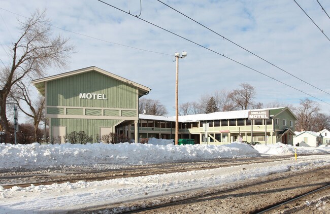


This Property Is For Sale
NEARBY LISTINGS FOR SALE OR LEASE
-
-
View all Minneapolis listings for sale on LoopNet.com
Property Detail
5346 Minnehaha Ave
Minneapolis-St. Paul-Bloomington, MN-WI
Minnehaha Parkview Addn To Mpls
17-028-23-33-0054
LOT 011 BLOCK 002 A MINNEHAHA PARKVIEW ADDN TO MPLS LOTS 10 TO 13 INCL NE192X148X118X128
Commercialnec
Hennepin
X
Minnesota
27053C0389F
11
2024
0.46 AC
2024
Bloomington
011998
Minneapolis/St Paul
13,979 SF
DEMOGRAPHICS near 5346 Minnehaha Ave
1 Mile
3 Mile
5 Mile
2024 Total Population
10,269
104,573
347,841
2029 Population
10,084
102,689
341,518
Pop Growth 2024-2029
(1.80%)
(1.80%)
(1.82%)
Average Age
43
41
38
2024 Total Households
5,052
45,131
144,888
HH Growth 2024-2029
(2.04%)
(1.96%)
(1.95%)
Median Household Inc
$78,846
$87,788
$73,534
Avg Household Size
2.00
2.20
2.20
2024 Avg HH Vehicles
1.00
2.00
2.00
Median Home Value
$277,099
$344,844
$335,244
Median Year Built
1950
1948
1949
Nearby Places
Map Layers
Map Styles
 Street
 Aerial
- Restaurants
- Banks
- Shops
- Fitness
- Groceries
PUBLIC TRANSPORTATION
COMMUTER RAIL
Target Field Station (Northstar Corridor - Northstar Commuter Rail)
DRIVE
WALK
Distance
Target Field Station (Northstar Corridor - Northstar Commuter Rail)
17 min
7.3 mi
DRIVE
WALK
Distance
16 min
8.6 mi
AIRPORT
Minneapolis-St Paul International/Wold-Chamberlain
DRIVE
WALK
Distance
Minneapolis-St Paul International/Wold-Chamberlain
9 min
4.2 mi
Nearby Properties
Address
Land Use
TOTAL SIZE
Lot Size
Zoning
Address
Land Use
TOTAL SIZE
Lot Size
Zoning
141,277 SF
44.78 AC
Address
Land Use
TOTAL SIZE
Lot Size
Zoning
84,316 SF
40.83 AC
Address
Land Use
TOTAL SIZE
Lot Size
Zoning
504,049 SF
75.43 AC
Address
Land Use
TOTAL SIZE
Lot Size
Zoning
176,108 SF
27.45 AC
Address
Land Use
TOTAL SIZE
Lot Size
Zoning
2.65 AC
Address
Land Use
TOTAL SIZE
Lot Size
Zoning
267,530 SF
28.60 AC
Address
Land Use
TOTAL SIZE
Lot Size
Zoning
173.22 AC
Address
Land Use
TOTAL SIZE
Lot Size
Zoning
Address
Land Use
TOTAL SIZE
Lot Size
Zoning
387,902 SF
14.81 AC
Address
Land Use
TOTAL SIZE
Lot Size
Zoning
429,720 SF
6.02 AC
Address
Land Use
TOTAL SIZE
Lot Size
Zoning
Address
Land Use
TOTAL SIZE
Lot Size
Zoning
378,880 SF
3.42 AC
Address
Land Use
TOTAL SIZE
Lot Size
Zoning
437,524 SF
6.11 AC
Address
Land Use
TOTAL SIZE
Lot Size
Zoning
233,588 SF
2.35 AC
Address
Land Use
TOTAL SIZE
Lot Size
Zoning
288,834 SF
1.72 AC
Address
Land Use
TOTAL SIZE
Lot Size
Zoning
2.18 AC
Address
Land Use
TOTAL SIZE
Lot Size
Zoning
Address
Land Use
TOTAL SIZE
Lot Size
Zoning
254,517 SF
2.22 AC
C3A
Address
Land Use
TOTAL SIZE
Lot Size
Zoning
Address
Land Use
TOTAL SIZE
Lot Size
Zoning
Address
Land Use
TOTAL SIZE
Lot Size
Zoning
Address
Land Use
TOTAL SIZE
Lot Size
Zoning
44,672 SF
63.51 AC
Address
Land Use
TOTAL SIZE
Lot Size
Zoning
165,618 SF
12.37 AC
Address
Land Use
TOTAL SIZE
Lot Size
Zoning
223,680 SF
2.61 AC
R5
Address
Land Use
TOTAL SIZE
Lot Size
Zoning
196,178 SF
1.26 AC
C3A
Address
Land Use
TOTAL SIZE
Lot Size
Zoning
16,075 SF
177.89 AC
Address
Land Use
TOTAL SIZE
Lot Size
Zoning
305,011 SF
8.61 AC
Address
Land Use
TOTAL SIZE
Lot Size
Zoning
8,208 SF
0.71 AC
Address
Land Use
TOTAL SIZE
Lot Size
Zoning
Address
Land Use
TOTAL SIZE
Lot Size
Zoning
169,522 SF
1.45 AC
C3A
The World's #1 Commercial Real Estate Marketplace
Connect with us
© 2026 CoStar Group
The information above has been obtained from sources believed reliable. While we do not doubt its accuracy we have not verified it and make no guarantee, warranty or representation about it. It is your responsibility to independently confirm its accuracy and completeness. Any projections, opinions, assumptions, or estimates used are for example only and do not represent the current or future performance of the property. The value of this transaction to you depends on tax and other factors which should be evaluated by your tax, financial, and legal advisors. You and your advisors should conduct a careful, independent investigation of the property to determine to your satisfaction the suitability of the property for your needs.