Property Record
535 N West Byp, Springfield, MO 65802


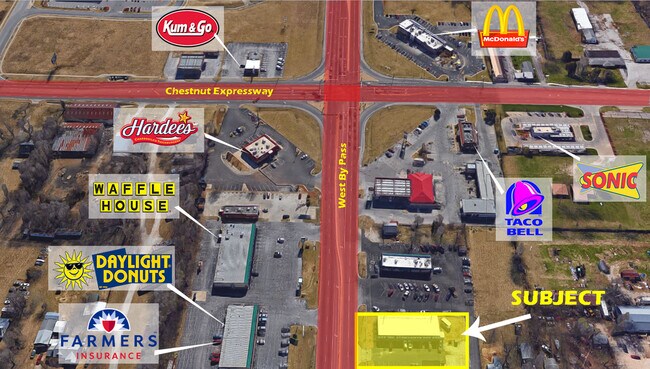
Property Detail
535 N West Byp
13-17-403-030
CARPENTER HGTS BEG 215 FT N SE COR LOT 17 N 57 FT W 150 FT S 57 FT E TO BEG (EX NEW R/W)
Stripcommercialcenter
GREENE
INC
Missouri
B and X Area of moderate flood hazard, usually the area between the limits of the 100-year and 500-year floods.
17
2025
0.18 AC
2025
Northwest
004304
Springfield
5,175 SF
Springfield, MO
NEARBY LISTINGS FOR SALE OR LEASE
DEMOGRAPHICS near 535 N West Byp
1 mile
3 mile
5 mile
2025 Total Population
7,197
53,680
133,286
2030 Population
7,360
55,525
137,094
Pop Growth 2025-2030
+ 2.26%
+ 3.44%
+ 2.86%
Average Age
40
37
37
2025 Total Households
2,779
22,553
56,920
HH Growth 2025-2030
+ 2.41%
+ 3.69%
+ 3.07%
Median Household Inc
$50,606
$48,632
$48,843
Avg Household Size
2.40
2.20
2.10
2025 Avg HH Vehicles
2.00
2.00
2.00
Median Home Value
$142,054
$149,519
$173,462
Median Year Built
1982
1984
1978
Nearby Places
Map Layers
Map Styles
 Street
 Aerial
Layers
 Traffic
 Biking
Places
Listings with unknown addresses are not visible on the map
- Restaurants
- Banks
- Shops
- Fitness
- Groceries
PUBLIC TRANSPORTATION
AIRPORT
Springfield-Branson Ntl
Drive
Walk
Distance
Springfield-Branson Ntl
16 min
5.9 mi
Freight Ports
Tulsa Port of Inola
Drive
Walk
Distance
Tulsa Port of Inola
187 min
168.1 mi
SALE & LEASE HISTORY
LISTING DATE
SALE/LEASE

Sep 25, 2016
For Lease
Oct 13, 2020
For Lease
Nov 18, 2022
For Sale
May 09, 2018
For Lease
Mar 08, 2024
For Sale
Jun 29, 2023
For Lease
Nearby Properties
Address
Land Use
TOTAL SIZE
Lot Size
Zoning
Address
Land Use
TOTAL SIZE
Lot Size
Zoning
320,532 SF
33.54 AC
INC
Address
Land Use
TOTAL SIZE
Lot Size
Zoning
23.75 AC
Address
Land Use
TOTAL SIZE
Lot Size
Zoning
22.64 AC
INC
Address
Land Use
TOTAL SIZE
Lot Size
Zoning
11 AC
INC
Address
Land Use
TOTAL SIZE
Lot Size
Zoning
334,594 SF
17.75 AC
INC
Address
Land Use
TOTAL SIZE
Lot Size
Zoning
511.19 AC
Address
Land Use
TOTAL SIZE
Lot Size
Zoning
253,781 SF
9.65 AC
INC
Address
Land Use
TOTAL SIZE
Lot Size
Zoning
234,926 SF
9.41 AC
INC
Address
Land Use
TOTAL SIZE
Lot Size
Zoning
102,925 SF
57.24 AC
INC
Address
Land Use
TOTAL SIZE
Lot Size
Zoning
2.92 AC
INC
Address
Land Use
TOTAL SIZE
Lot Size
Zoning
93,916 SF
7.91 AC
INC
Address
Land Use
TOTAL SIZE
Lot Size
Zoning
29.42 AC
INC
Address
Land Use
TOTAL SIZE
Lot Size
Zoning
65,208 SF
12.40 AC
INC
Address
Land Use
TOTAL SIZE
Lot Size
Zoning
10.76 AC
INC
Address
Land Use
TOTAL SIZE
Lot Size
Zoning
172,976 SF
5.99 AC
INC
Address
Land Use
TOTAL SIZE
Lot Size
Zoning
157,773 SF
18.55 AC
INC
Address
Land Use
TOTAL SIZE
Lot Size
Zoning
154,470 SF
16.97 AC
INC
Address
Land Use
TOTAL SIZE
Lot Size
Zoning
16.39 AC
INC
Address
Land Use
TOTAL SIZE
Lot Size
Zoning
20.54 AC
Address
Land Use
TOTAL SIZE
Lot Size
Zoning
Address
Land Use
TOTAL SIZE
Lot Size
Zoning
83,380 SF
7.20 AC
INC
Address
Land Use
TOTAL SIZE
Lot Size
Zoning
Address
Land Use
TOTAL SIZE
Lot Size
Zoning
12.39 AC
Address
Land Use
TOTAL SIZE
Lot Size
Zoning
78,239 SF
10.01 AC
INC
Address
Land Use
TOTAL SIZE
Lot Size
Zoning
Address
Land Use
TOTAL SIZE
Lot Size
Zoning
77,160 SF
6.31 AC
INC
Address
Land Use
TOTAL SIZE
Lot Size
Zoning
55,568 SF
2.13 AC
INC
Address
Land Use
TOTAL SIZE
Lot Size
Zoning
44,000 SF
3.05 AC
INC
Address
Land Use
TOTAL SIZE
Lot Size
Zoning
75,000 SF
8.92 AC
INC
Address
Land Use
TOTAL SIZE
Lot Size
Zoning
20,211 SF
2.25 AC
INC.
The World's #1 Commercial Real Estate Marketplace
Connect with us
© 2026 CoStar Group
The information above has been obtained from sources believed reliable. While we do not doubt its accuracy we have not verified it and make no guarantee, warranty or representation about it. It is your responsibility to independently confirm its accuracy and completeness. Any projections, opinions, assumptions, or estimates used are for example only and do not represent the current or future performance of the property. The value of this transaction to you depends on tax and other factors which should be evaluated by your tax, financial, and legal advisors. You and your advisors should conduct a careful, independent investigation of the property to determine to your satisfaction the suitability of the property for your needs.