Property Record
535 Parsells Ave, Rochester, NY 14609
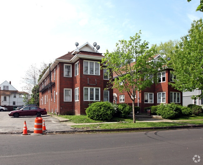

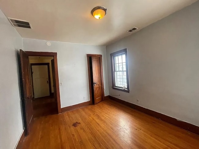
This Property Is For Sale
NEARBY LISTINGS FOR SALE OR LEASE
Property Detail
535 Parsells Ave
Rochester, NY
Morris Levins Subdivision
261400-107-550-0003-048-000-0000
0058.00 205 18 03850 A M LEVIN SUB
Apartment
Monroe
X
New York
36055C0212G
48.000
2025
0.29 AC
2024
Beechwood
005800
Rochester
9,298 SF
DEMOGRAPHICS near 535 Parsells Ave
1 Mile
3 Mile
5 Mile
2024 Total Population
23,600
143,823
298,747
2029 Population
23,091
141,639
294,196
Pop Growth 2024-2029
(2.16%)
(1.52%)
(1.52%)
Average Age
37
39
39
2024 Total Households
10,145
67,108
130,389
HH Growth 2024-2029
(2.32%)
(1.51%)
(1.55%)
Median Household Inc
$54,080
$52,500
$53,299
Avg Household Size
2.20
2.00
2.20
2024 Avg HH Vehicles
1.00
1.00
1.00
Median Home Value
$119,007
$152,258
$158,059
Median Year Built
1946
1948
1949
Nearby Places
Map Layers
Map Styles
 Street
 Aerial
- Restaurants
- Banks
- Shops
- Fitness
- Groceries
PUBLIC TRANSPORTATION
COMMUTER RAIL
DRIVE
WALK
Distance
6 min
2.9 mi
AIRPORT
Frederick Douglass/Greater Rochester International
DRIVE
WALK
Distance
Frederick Douglass/Greater Rochester International
15 min
7.6 mi
Nearby Properties
Address
Land Use
TOTAL SIZE
Lot Size
Zoning
Address
Land Use
TOTAL SIZE
Lot Size
Zoning
847,728 SF
41.57 AC
Address
Land Use
TOTAL SIZE
Lot Size
Zoning
0.47 AC
Address
Land Use
TOTAL SIZE
Lot Size
Zoning
7.15 AC
Address
Land Use
TOTAL SIZE
Lot Size
Zoning
0.13 AC
Address
Land Use
TOTAL SIZE
Lot Size
Zoning
51,276 SF
48.95 AC
02 - SINGL
Address
Land Use
TOTAL SIZE
Lot Size
Zoning
614,053 SF
9.30 AC
Address
Land Use
TOTAL SIZE
Lot Size
Zoning
373,200 SF
5.42 AC
Address
Land Use
TOTAL SIZE
Lot Size
Zoning
178,321 SF
3.10 AC
Address
Land Use
TOTAL SIZE
Lot Size
Zoning
0.01 AC
Address
Land Use
TOTAL SIZE
Lot Size
Zoning
302,484 SF
2.53 AC
Address
Land Use
TOTAL SIZE
Lot Size
Zoning
473,876 SF
1.49 AC
Address
Land Use
TOTAL SIZE
Lot Size
Zoning
342,266 SF
1.44 AC
Address
Land Use
TOTAL SIZE
Lot Size
Zoning
7,200 SF
12.35 AC
Address
Land Use
TOTAL SIZE
Lot Size
Zoning
0.41 AC
Address
Land Use
TOTAL SIZE
Lot Size
Zoning
0.01 AC
Address
Land Use
TOTAL SIZE
Lot Size
Zoning
416,083 SF
0.94 AC
Address
Land Use
TOTAL SIZE
Lot Size
Zoning
323,264 SF
21.06 AC
06 - INDUS
Address
Land Use
TOTAL SIZE
Lot Size
Zoning
198,655 SF
31.05 AC
02 - SINGL
Address
Land Use
TOTAL SIZE
Lot Size
Zoning
0.01 AC
Address
Land Use
TOTAL SIZE
Lot Size
Zoning
0.65 AC
Address
Land Use
TOTAL SIZE
Lot Size
Zoning
491,375 SF
5.90 AC
Address
Land Use
TOTAL SIZE
Lot Size
Zoning
161,812 SF
5.18 AC
06 - INDUS
Address
Land Use
TOTAL SIZE
Lot Size
Zoning
273,900 SF
0.74 AC
Address
Land Use
TOTAL SIZE
Lot Size
Zoning
336,447 SF
1.38 AC
Address
Land Use
TOTAL SIZE
Lot Size
Zoning
335,918 SF
10.19 AC
Address
Land Use
TOTAL SIZE
Lot Size
Zoning
151,590 SF
1.14 AC
Address
Land Use
TOTAL SIZE
Lot Size
Zoning
233,579 SF
1.13 AC
Address
Land Use
TOTAL SIZE
Lot Size
Zoning
193,892 SF
18.62 AC
05 - COMME
Address
Land Use
TOTAL SIZE
Lot Size
Zoning
261,960 SF
3.73 AC
Address
Land Use
TOTAL SIZE
Lot Size
Zoning
266,701 SF
4.10 AC
The World's #1 Commercial Real Estate Marketplace
Connect with us
© 2026 CoStar Group
The information above has been obtained from sources believed reliable. While we do not doubt its accuracy we have not verified it and make no guarantee, warranty or representation about it. It is your responsibility to independently confirm its accuracy and completeness. Any projections, opinions, assumptions, or estimates used are for example only and do not represent the current or future performance of the property. The value of this transaction to you depends on tax and other factors which should be evaluated by your tax, financial, and legal advisors. You and your advisors should conduct a careful, independent investigation of the property to determine to your satisfaction the suitability of the property for your needs.