Property Record
535 W Tefft St, Nipomo, CA 93444
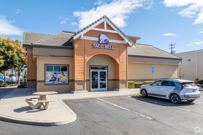

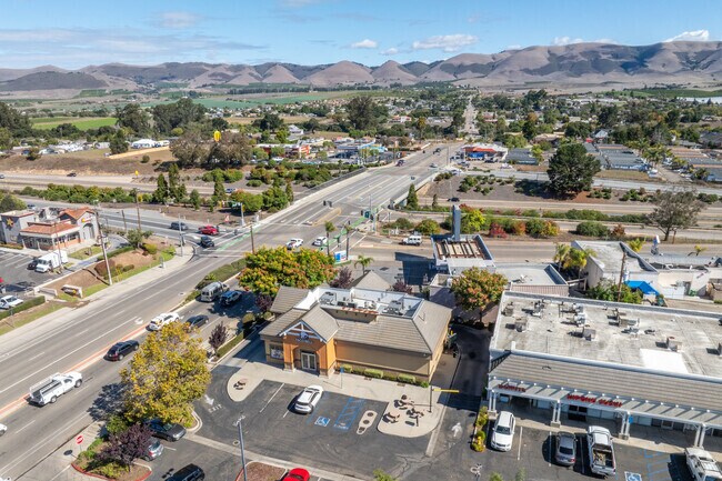
Property Detail
535 W Tefft St
092-576-009
PM 55/83 PAR 3
Restaurantdrivein
San Luis Obispo
CR
California
B and X Area of moderate flood hazard, usually the area between the limits of the 100-year and 500-year floods.
0.43 AC
2024
South 101 Corridor
2025
San Luis Obispo/Paso Robles
012404
San Luis Obispo-Paso Robles, CA
NEARBY LISTINGS FOR SALE OR LEASE
-
-
View all Nipomo listings for sale on LoopNet.com
DEMOGRAPHICS near 535 W Tefft St
1 mile
3 mile
5 mile
2025 Total Population
8,593
16,143
33,256
2030 Population
8,297
15,556
32,425
Pop Growth 2025-2030
(3.44%)
(3.64%)
(2.50%)
Average Age
38
41
41
2025 Total Households
2,805
5,419
10,652
HH Growth 2025-2030
(3.81%)
(3.99%)
(2.73%)
Median Household Inc
$94,744
$103,409
$106,337
Avg Household Size
2.90
2.90
2.90
2025 Avg HH Vehicles
2.00
3.00
2.00
Median Home Value
$703,101
$766,673
$751,306
Median Year Built
1988
1986
1990
Nearby Places
Map Layers
Map Styles
 Street
 Aerial
Layers
 Traffic
 Biking
Places
Listings with unknown addresses are not visible on the map
- Restaurants
- Banks
- Shops
- Fitness
- Groceries
PUBLIC TRANSPORTATION
COMMUTER RAIL
Drive
Walk
Distance
16 min
9.2 mi
AIRPORT
San Luis County Regional
Drive
Walk
Distance
San Luis County Regional
28 min
20.0 mi
Nearby Properties
Address
Land Use
TOTAL SIZE
Lot Size
Zoning
Address
Land Use
TOTAL SIZE
Lot Size
Zoning
81,330 SF
4.15 AC
CR
Address
Land Use
TOTAL SIZE
Lot Size
Zoning
2.61 AC
RMF
Address
Land Use
TOTAL SIZE
Lot Size
Zoning
4.50 AC
RMF
Address
Land Use
TOTAL SIZE
Lot Size
Zoning
728 SF
4.50 AC
PF
Address
Land Use
TOTAL SIZE
Lot Size
Zoning
3.11 AC
RMF
Address
Land Use
TOTAL SIZE
Lot Size
Zoning
34.30 AC
RR
Address
Land Use
TOTAL SIZE
Lot Size
Zoning
4 AC
RMF
Address
Land Use
TOTAL SIZE
Lot Size
Zoning
Address
Land Use
TOTAL SIZE
Lot Size
Zoning
276.22 AC
Address
Land Use
TOTAL SIZE
Lot Size
Zoning
41,631 SF
4.45 AC
CR
Address
Land Use
TOTAL SIZE
Lot Size
Zoning
20,118 SF
2.11 AC
CR
Address
Land Use
TOTAL SIZE
Lot Size
Zoning
18,065 SF
1.01 AC
CR
Address
Land Use
TOTAL SIZE
Lot Size
Zoning
39,348 SF
3.53 AC
CS
Address
Land Use
TOTAL SIZE
Lot Size
Zoning
39.09 AC
RR
Address
Land Use
TOTAL SIZE
Lot Size
Zoning
57,000 SF
3.16 AC
CS
Address
Land Use
TOTAL SIZE
Lot Size
Zoning
16,140 SF
1.36 AC
CS
Address
Land Use
TOTAL SIZE
Lot Size
Zoning
16,640 SF
1.92 AC
CR
Address
Land Use
TOTAL SIZE
Lot Size
Zoning
198 AC
AG
Address
Land Use
TOTAL SIZE
Lot Size
Zoning
1.26 AC
RMF
Address
Land Use
TOTAL SIZE
Lot Size
Zoning
35,680 SF
3.86 AC
CR
Address
Land Use
TOTAL SIZE
Lot Size
Zoning
20,652 SF
1.91 AC
CR
Address
Land Use
TOTAL SIZE
Lot Size
Zoning
24,057 SF
1.85 AC
CS
Address
Land Use
TOTAL SIZE
Lot Size
Zoning
4,898 SF
210 AC
AG
Address
Land Use
TOTAL SIZE
Lot Size
Zoning
16.02 AC
CS
Address
Land Use
TOTAL SIZE
Lot Size
Zoning
21,400 SF
2 AC
CR
Address
Land Use
TOTAL SIZE
Lot Size
Zoning
22,082 SF
1.33 AC
RMF
Address
Land Use
TOTAL SIZE
Lot Size
Zoning
2,049 SF
114 AC
AG
Address
Land Use
TOTAL SIZE
Lot Size
Zoning
327.30 AC
AG
Address
Land Use
TOTAL SIZE
Lot Size
Zoning
122.84 AC
AG
Address
Land Use
TOTAL SIZE
Lot Size
Zoning
7,708 SF
0.64 AC
CR
The World's #1 Commercial Real Estate Marketplace
Connect with us
© 2026 CoStar Group
The information above has been obtained from sources believed reliable. While we do not doubt its accuracy we have not verified it and make no guarantee, warranty or representation about it. It is your responsibility to independently confirm its accuracy and completeness. Any projections, opinions, assumptions, or estimates used are for example only and do not represent the current or future performance of the property. The value of this transaction to you depends on tax and other factors which should be evaluated by your tax, financial, and legal advisors. You and your advisors should conduct a careful, independent investigation of the property to determine to your satisfaction the suitability of the property for your needs.