Property Record
5350 E 30Th St, Tucson, AZ 85711
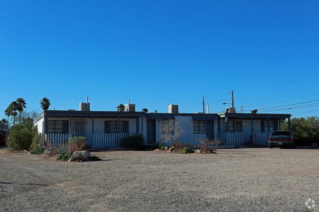
Property Detail
5350 E 30Th St
131-01-0560
N169 S989.92 W120 E760 NE4 SE4 .56 AC SEC 23-14-14
Apartment
Pima
R3
Arizona
B and X Area of moderate flood hazard, usually the area between the limits of the 100-year and 500-year floods.
16
2025
0.40 AC
2026
Myers
003503
Tucson
3,024 SF
Tucson, AZ
NEARBY LISTINGS FOR SALE OR LEASE
DEMOGRAPHICS near 5350 E 30Th St
1 mile
3 mile
5 mile
2025 Total Population
13,574
91,404
261,859
2030 Population
13,875
93,405
267,952
Pop Growth 2025-2030
+ 2.22%
+ 2.19%
+ 2.33%
Average Age
37
39
40
2025 Total Households
5,407
38,607
112,435
HH Growth 2025-2030
+ 2.37%
+ 2.22%
+ 2.44%
Median Household Inc
$44,721
$54,053
$55,689
Avg Household Size
2.40
2.20
2.20
2025 Avg HH Vehicles
2.00
2.00
2.00
Median Home Value
$240,550
$269,286
$280,311
Median Year Built
1966
1968
1973
Nearby Places
Map Layers
Map Styles
 Street
 Aerial
Transit
 Traffic
 Biking
Places
Listings with unknown addresses are not visible on the map
- Restaurants
- Banks
- Shops
- Fitness
- Groceries
PUBLIC TRANSPORTATION
COMMUTER RAIL
Drive
Walk
Distance
12 min
6.9 mi
AIRPORT
Tucson International
Drive
Walk
Distance
Tucson International
16 min
9.3 mi
SALE & LEASE HISTORY
LISTING DATE
SALE/LEASE

Jun 09, 2025
For Sale
Nearby Properties
Address
Land Use
TOTAL SIZE
Lot Size
Zoning
Address
Land Use
TOTAL SIZE
Lot Size
Zoning
2,315,205 SF
628.02 AC
I1
Address
Land Use
TOTAL SIZE
Lot Size
Zoning
53,431 SF
9.98 AC
Address
Land Use
TOTAL SIZE
Lot Size
Zoning
2,041,946 SF
640 AC
I1
Address
Land Use
TOTAL SIZE
Lot Size
Zoning
684,356 SF
19.65 AC
PAD13
Address
Land Use
TOTAL SIZE
Lot Size
Zoning
594,802 SF
62.57 AC
Address
Land Use
TOTAL SIZE
Lot Size
Zoning
473,573 SF
22.65 AC
C3
Address
Land Use
TOTAL SIZE
Lot Size
Zoning
41,486 SF
0.93 AC
C2
Address
Land Use
TOTAL SIZE
Lot Size
Zoning
259,645 SF
37.28 AC
R1
Address
Land Use
TOTAL SIZE
Lot Size
Zoning
421,674 SF
8.10 AC
OCR2
Address
Land Use
TOTAL SIZE
Lot Size
Zoning
241,706 SF
160 AC
R1
Address
Land Use
TOTAL SIZE
Lot Size
Zoning
137,890 SF
8.28 AC
PAD1
Address
Land Use
TOTAL SIZE
Lot Size
Zoning
435,634 SF
4.29 AC
PAD1
Address
Land Use
TOTAL SIZE
Lot Size
Zoning
174,364 SF
7.36 AC
Address
Land Use
TOTAL SIZE
Lot Size
Zoning
31,672 SF
3 AC
CI2
Address
Land Use
TOTAL SIZE
Lot Size
Zoning
209,980 SF
6.16 AC
C2
Address
Land Use
TOTAL SIZE
Lot Size
Zoning
256,775 SF
6.69 AC
C1
Address
Land Use
TOTAL SIZE
Lot Size
Zoning
109,335 SF
7.83 AC
PAD13
Address
Land Use
TOTAL SIZE
Lot Size
Zoning
194,800 SF
477.22 AC
R1
Address
Land Use
TOTAL SIZE
Lot Size
Zoning
162,473 SF
6.08 AC
C3
Address
Land Use
TOTAL SIZE
Lot Size
Zoning
318,290 SF
32 AC
R1
Address
Land Use
TOTAL SIZE
Lot Size
Zoning
217,152 SF
5.37 AC
PAD1
Address
Land Use
TOTAL SIZE
Lot Size
Zoning
136,235 SF
8.46 AC
CI1
Address
Land Use
TOTAL SIZE
Lot Size
Zoning
286,164 SF
5.80 AC
C3
Address
Land Use
TOTAL SIZE
Lot Size
Zoning
195,798 SF
12.04 AC
OCR2
Address
Land Use
TOTAL SIZE
Lot Size
Zoning
118,655 SF
8.74 AC
C1
Address
Land Use
TOTAL SIZE
Lot Size
Zoning
127,872 SF
2.59 AC
C1
Address
Land Use
TOTAL SIZE
Lot Size
Zoning
268,026 SF
16 AC
R3
Address
Land Use
TOTAL SIZE
Lot Size
Zoning
11,074 SF
0.94 AC
C1
Address
Land Use
TOTAL SIZE
Lot Size
Zoning
100,368 SF
7.04 AC
Address
Land Use
TOTAL SIZE
Lot Size
Zoning
154,077 SF
10.41 AC
C2
The World's #1 Commercial Real Estate Marketplace
Connect with us
© 2026 CoStar Group
The information above has been obtained from sources believed reliable. While we do not doubt its accuracy we have not verified it and make no guarantee, warranty or representation about it. It is your responsibility to independently confirm its accuracy and completeness. Any projections, opinions, assumptions, or estimates used are for example only and do not represent the current or future performance of the property. The value of this transaction to you depends on tax and other factors which should be evaluated by your tax, financial, and legal advisors. You and your advisors should conduct a careful, independent investigation of the property to determine to your satisfaction the suitability of the property for your needs.