Property Record
5351 Eaton Dr, Milton, FL 32583
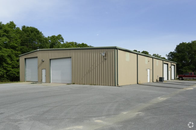
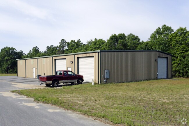

Property Detail
5351 Eaton Dr
06-1N-27-0000-00400-0000
***NEW DESCRIPTION FOR 2021*** BEING THE PORTION OF FOLLOWING LYING IN SEC 6 TOWNSHIP 2 NORT H RANGE 27 WEST FURTHER DES AS COM AT NE COR OF NW4 OF SEC 6 TH W 756.88 FT TO POB TH S AT RIGHT ANGLE 742.4 FT TH W RIGHT ANGLE 208.72 FT TH N RIGHT ANGLE 1
Officebuilding
SANTA ROSA
HCD
Florida
B and X Area of moderate flood hazard, usually the area between the limits of the 100-year and 500-year floods.
48
2024
3.54 AC
2025
SE Santa Rosa County
010709
Pensacola
7,000 SF
Pensacola-Ferry Pass-Brent, FL
NEARBY LISTINGS FOR SALE OR LEASE
-
-
View all Milton listings for sale on LoopNet.com
DEMOGRAPHICS near 5351 Eaton Dr
1 mile
3 mile
5 mile
2025 Total Population
1,521
12,092
36,827
2030 Population
1,670
13,078
40,031
Pop Growth 2025-2030
+ 9.80%
+ 8.15%
+ 8.70%
Average Age
43
42
41
2025 Total Households
592
3,471
13,006
HH Growth 2025-2030
+ 9.63%
+ 9.33%
+ 8.96%
Median Household Inc
$79,266
$69,381
$70,631
Avg Household Size
2.50
2.50
2.50
2025 Avg HH Vehicles
2.00
2.00
2.00
Median Home Value
$322,697
$263,003
$241,346
Median Year Built
1987
1990
1990
Nearby Places
Map Layers
Map Styles
 Street
 Aerial
Layers
 Traffic
 Biking
Places
Listings with unknown addresses are not visible on the map
- Restaurants
- Banks
- Shops
- Fitness
- Groceries
PUBLIC TRANSPORTATION
AIRPORT
Pensacola International
Drive
Walk
Distance
Pensacola International
31 min
23.6 mi
Eglin AFB/Destin-Ft Walton Beach
Drive
Walk
Distance
Eglin AFB/Destin-Ft Walton Beach
54 min
48.2 mi
Nearby Properties
Address
Land Use
TOTAL SIZE
Lot Size
Zoning
Address
Land Use
TOTAL SIZE
Lot Size
Zoning
342,125 SF
58.46 AC
M2
Address
Land Use
TOTAL SIZE
Lot Size
Zoning
281,607 SF
306.03 AC
M2
Address
Land Use
TOTAL SIZE
Lot Size
Zoning
183,076 SF
85.91 AC
M2
Address
Land Use
TOTAL SIZE
Lot Size
Zoning
198,543 SF
34.63 AC
M2
Address
Land Use
TOTAL SIZE
Lot Size
Zoning
31,124 SF
36.55 AC
AG-RR
Address
Land Use
TOTAL SIZE
Lot Size
Zoning
258,149 SF
8.42 AC
M2
Address
Land Use
TOTAL SIZE
Lot Size
Zoning
197,050 SF
29.93 AC
M2
Address
Land Use
TOTAL SIZE
Lot Size
Zoning
141,508 SF
26.62 AC
M2
Address
Land Use
TOTAL SIZE
Lot Size
Zoning
164,844 SF
8.33 AC
M2
Address
Land Use
TOTAL SIZE
Lot Size
Zoning
68,026 SF
2.07 AC
RC1
Address
Land Use
TOTAL SIZE
Lot Size
Zoning
52,817 SF
79.32 AC
M1
Address
Land Use
TOTAL SIZE
Lot Size
Zoning
67,182 SF
9.54 AC
M2
Address
Land Use
TOTAL SIZE
Lot Size
Zoning
47,976 SF
102.61 AC
M2
Address
Land Use
TOTAL SIZE
Lot Size
Zoning
186.32 AC
HCD
Address
Land Use
TOTAL SIZE
Lot Size
Zoning
82,869 SF
10 AC
M2
Address
Land Use
TOTAL SIZE
Lot Size
Zoning
16,903 SF
11 AC
AG-RR
Address
Land Use
TOTAL SIZE
Lot Size
Zoning
9,030 SF
20.47 AC
HCD
Address
Land Use
TOTAL SIZE
Lot Size
Zoning
72,675 SF
20 AC
M2
Address
Land Use
TOTAL SIZE
Lot Size
Zoning
103,000 SF
7.24 AC
M2
Address
Land Use
TOTAL SIZE
Lot Size
Zoning
89,249 SF
66.21 AC
AG-RR
Address
Land Use
TOTAL SIZE
Lot Size
Zoning
81,521 SF
7.63 AC
M2
Address
Land Use
TOTAL SIZE
Lot Size
Zoning
51,765 SF
14 AC
M2
Address
Land Use
TOTAL SIZE
Lot Size
Zoning
83,222 SF
7 AC
M2
Address
Land Use
TOTAL SIZE
Lot Size
Zoning
38,619 SF
2.31 AC
HCD
Address
Land Use
TOTAL SIZE
Lot Size
Zoning
199.56 AC
AG-RR
Address
Land Use
TOTAL SIZE
Lot Size
Zoning
38,797 SF
2.81 AC
R2
Address
Land Use
TOTAL SIZE
Lot Size
Zoning
9,058 SF
8.35 AC
I1
Address
Land Use
TOTAL SIZE
Lot Size
Zoning
33,570 SF
4.25 AC
HCD
Address
Land Use
TOTAL SIZE
Lot Size
Zoning
33,454 SF
13.16 AC
M2
Address
Land Use
TOTAL SIZE
Lot Size
Zoning
82,362 SF
6.95 AC
M2
The World's #1 Commercial Real Estate Marketplace
Connect with us
© 2026 CoStar Group
The information above has been obtained from sources believed reliable. While we do not doubt its accuracy we have not verified it and make no guarantee, warranty or representation about it. It is your responsibility to independently confirm its accuracy and completeness. Any projections, opinions, assumptions, or estimates used are for example only and do not represent the current or future performance of the property. The value of this transaction to you depends on tax and other factors which should be evaluated by your tax, financial, and legal advisors. You and your advisors should conduct a careful, independent investigation of the property to determine to your satisfaction the suitability of the property for your needs.