Property Record
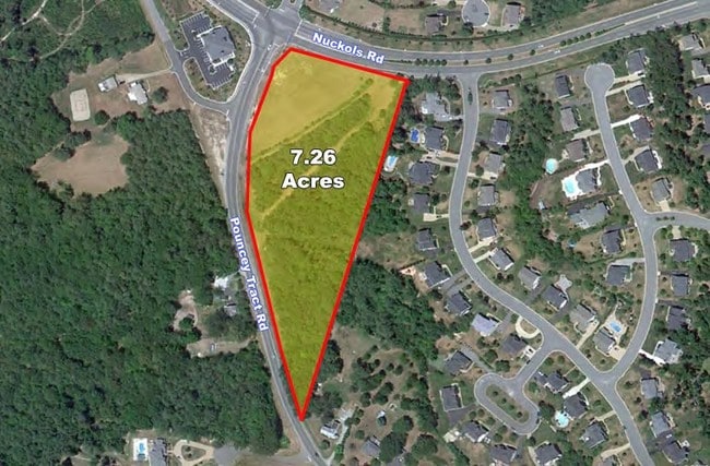
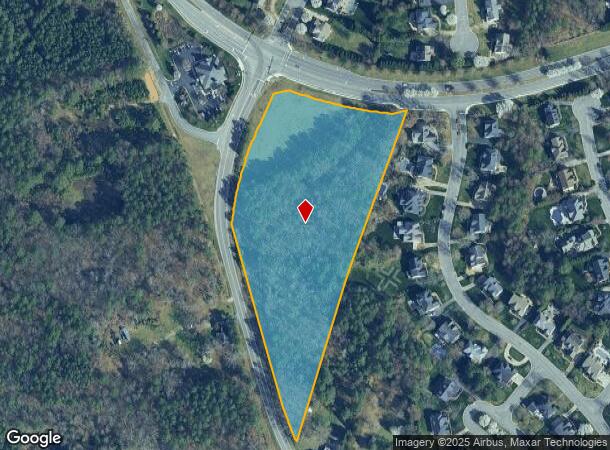
5351 Pouncey Tract Rd, Glen Allen, VA 23059
NEARBY LISTINGS FOR SALE OR LEASE
Property Detail
5351 Pouncey Tract Rd
736-773-5461
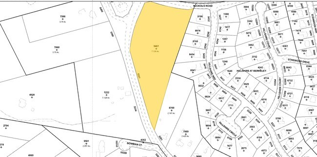
00170A0000 0003; POUNCEY TRACT RD AC 7.126 73 A2 6
Vacantlandnec
Henrico
X
Virginia
51085C0290C
7.13 AC
2025
Innsbrook
2025
Richmond VA
320300
Richmond, VA
DEMOGRAPHICS near 5351 Pouncey Tract Rd
1 Mile
3 Mile
5 Mile
2024 Total Population
6,518
43,179
101,724
2029 Population
6,538
43,609
102,492
Pop Growth 2024-2029
+ 0.31%
+ 1.00%
+ 0.75%
Average Age
37
38
40
2024 Total Households
2,154
15,028
38,912
HH Growth 2024-2029
+ 0.28%
+ 1.14%
+ 0.86%
Median Household Inc
$218,603
$162,084
$119,684
Avg Household Size
3.00
2.80
2.60
2024 Avg HH Vehicles
2.00
2.00
2.00
Median Home Value
$679,414
$604,810
$448,108
Median Year Built
2006
2003
1994
Nearby Places
Map Layers
Map Styles
 Street
 Aerial
- Restaurants
- Banks
- Shops
- Fitness
- Groceries
PUBLIC TRANSPORTATION
AIRPORT
Richmond International
DRIVE
WALK
Distance
Richmond International
37 min
24.5 mi
Freight Ports
Virginia Port Authority - Richmond
DRIVE
WALK
Distance
Virginia Port Authority - Richmond
34 min
22.8 mi
SALE & LEASE HISTORY
LISTING DATE
SALE/LEASE

Oct 07, 2019
For Sale
Nearby Properties
Address
Land Use
TOTAL SIZE
Lot Size
Zoning
Address
Land Use
TOTAL SIZE
Lot Size
Zoning
10,290 SF
56.53 AC
B-3C
Address
Land Use
TOTAL SIZE
Lot Size
Zoning
93.75 AC
M1-INDUS/L
Address
Land Use
TOTAL SIZE
Lot Size
Zoning
37.36 AC
R-5C
Address
Land Use
TOTAL SIZE
Lot Size
Zoning
227,483 SF
12.10 AC
M1-INDUS/L
Address
Land Use
TOTAL SIZE
Lot Size
Zoning
112,224 SF
20.53 AC
MIXE
Address
Land Use
TOTAL SIZE
Lot Size
Zoning
57,104 SF
0.02 AC
UMUC
Address
Land Use
TOTAL SIZE
Lot Size
Zoning
403,784 SF
40.74 AC
MIXE
Address
Land Use
TOTAL SIZE
Lot Size
Zoning
417,042 SF
49.96 AC
O-3C
Address
Land Use
TOTAL SIZE
Lot Size
Zoning
3,077 SF
19.89 AC
M1-INDUS/L
Address
Land Use
TOTAL SIZE
Lot Size
Zoning
254,325 SF
60.28 AC
A-1
Address
Land Use
TOTAL SIZE
Lot Size
Zoning
340 SF
23.32 AC
MIXE
Address
Land Use
TOTAL SIZE
Lot Size
Zoning
278,084 SF
21.70 AC
R-6C
Address
Land Use
TOTAL SIZE
Lot Size
Zoning
309,156 SF
17.13 AC
R-6
Address
Land Use
TOTAL SIZE
Lot Size
Zoning
282,400 SF
18.71 AC
MIXE
Address
Land Use
TOTAL SIZE
Lot Size
Zoning
289,752 SF
24.72 AC
R-5C
Address
Land Use
TOTAL SIZE
Lot Size
Zoning
7.98 AC
UMUC
Address
Land Use
TOTAL SIZE
Lot Size
Zoning
138,713 SF
46.53 AC
A-1
Address
Land Use
TOTAL SIZE
Lot Size
Zoning
326,755 SF
36.20 AC
O-3C
Address
Land Use
TOTAL SIZE
Lot Size
Zoning
5,590 SF
11.54 AC
B-2C
Address
Land Use
TOTAL SIZE
Lot Size
Zoning
329,044 SF
8.09 AC
UMUC
Address
Land Use
TOTAL SIZE
Lot Size
Zoning
358,228 SF
3.30 AC
UMUC
Address
Land Use
TOTAL SIZE
Lot Size
Zoning
55,769 SF
14.13 AC
MIXE
Address
Land Use
TOTAL SIZE
Lot Size
Zoning
111,487 SF
2.92 AC
B-2C
Address
Land Use
TOTAL SIZE
Lot Size
Zoning
23,378 SF
0.02 AC
UMUC
Address
Land Use
TOTAL SIZE
Lot Size
Zoning
164,680 SF
33.86 AC
MIXE
Address
Land Use
TOTAL SIZE
Lot Size
Zoning
20,864 SF
15.28 AC
MIXE
Address
Land Use
TOTAL SIZE
Lot Size
Zoning
10,282 SF
2.13 AC
B-3C
Address
Land Use
TOTAL SIZE
Lot Size
Zoning
117,605 SF
29.24 AC
A-1
Address
Land Use
TOTAL SIZE
Lot Size
Zoning
58,446 SF
12.71 AC
B-3C
Address
Land Use
TOTAL SIZE
Lot Size
Zoning
187,283 SF
5.22 AC
B-2C
The World's #1 Commercial Real Estate Marketplace
Connect with us
© 2026 CoStar Group
The information above has been obtained from sources believed reliable. While we do not doubt its accuracy we have not verified it and make no guarantee, warranty or representation about it. It is your responsibility to independently confirm its accuracy and completeness. Any projections, opinions, assumptions, or estimates used are for example only and do not represent the current or future performance of the property. The value of this transaction to you depends on tax and other factors which should be evaluated by your tax, financial, and legal advisors. You and your advisors should conduct a careful, independent investigation of the property to determine to your satisfaction the suitability of the property for your needs.