Property Record
536 Harmon Johnson Rd, Monroe, LA 71202
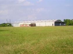

Property Detail
536 Harmon Johnson Rd
Monroe, LA
5 ACS IN SEC 1 T16N R3E BEG 42.51 FT W OF E4 COR SEC 1, W 366.5 FT, N 597.89 FT, E 366.43 FT, S 590.82 FT TO BEG
79666
OUACHITA
Industrialgeneral
Louisiana
C and X Area of minimal flood hazard, usually depicted on FIRMs as above the 500-year flood level.
5 AC
2025
Louisiana North Area
2025
Other Market Areas
011000
NEARBY LISTINGS FOR SALE OR LEASE
-
-
View all Monroe listings for sale on LoopNet.com
DEMOGRAPHICS near 536 Harmon Johnson Rd
1 mile
3 mile
5 mile
2025 Total Population
191
2,989
16,047
2030 Population
194
2,943
16,035
Pop Growth 2025-2030
+ 1.57%
(1.54%)
(0.07%)
Average Age
42
36
37
2025 Total Households
79
1,003
5,009
HH Growth 2025-2030
+ 1.27%
(1.20%)
+ 0.08%
Median Household Inc
$41,875
$31,574
$34,701
Avg Household Size
2.50
2.80
2.70
2025 Avg HH Vehicles
2.00
2.00
1.00
Median Home Value
$114,706
$128,698
$95,386
Median Year Built
1980
1977
1976
Nearby Places
Map Layers
Map Styles
 Street
 Aerial
Transit
 Traffic
 Biking
Places
Listings with unknown addresses are not visible on the map
- Restaurants
- Banks
- Shops
- Fitness
- Groceries
PUBLIC TRANSPORTATION
AIRPORT
Monroe Regional
Drive
Walk
Distance
Monroe Regional
15 min
10.2 mi
Freight Ports
Port of Shreveport
Drive
Walk
Distance
Port of Shreveport
139 min
117.6 mi
Nearby Properties
Address
Land Use
TOTAL SIZE
Lot Size
Zoning
Address
Land Use
TOTAL SIZE
Lot Size
Zoning
22.64 AC
Address
Land Use
TOTAL SIZE
Lot Size
Zoning
Address
Land Use
TOTAL SIZE
Lot Size
Zoning
3.22 AC
Address
Land Use
TOTAL SIZE
Lot Size
Zoning
2.26 AC
Address
Land Use
TOTAL SIZE
Lot Size
Zoning
36.91 AC
Address
Land Use
TOTAL SIZE
Lot Size
Zoning
Address
Land Use
TOTAL SIZE
Lot Size
Zoning
Address
Land Use
TOTAL SIZE
Lot Size
Zoning
83.92 AC
Address
Land Use
TOTAL SIZE
Lot Size
Zoning
Address
Land Use
TOTAL SIZE
Lot Size
Zoning
36.25 AC
Address
Land Use
TOTAL SIZE
Lot Size
Zoning
14.91 AC
Address
Land Use
TOTAL SIZE
Lot Size
Zoning
Address
Land Use
TOTAL SIZE
Lot Size
Zoning
Address
Land Use
TOTAL SIZE
Lot Size
Zoning
120.51 AC
Address
Land Use
TOTAL SIZE
Lot Size
Zoning
Address
Land Use
TOTAL SIZE
Lot Size
Zoning
Address
Land Use
TOTAL SIZE
Lot Size
Zoning
3.07 AC
Address
Land Use
TOTAL SIZE
Lot Size
Zoning
0.85 AC
Address
Land Use
TOTAL SIZE
Lot Size
Zoning
Address
Land Use
TOTAL SIZE
Lot Size
Zoning
24.98 AC
Address
Land Use
TOTAL SIZE
Lot Size
Zoning
Address
Land Use
TOTAL SIZE
Lot Size
Zoning
1.02 AC
Address
Land Use
TOTAL SIZE
Lot Size
Zoning
Address
Land Use
TOTAL SIZE
Lot Size
Zoning
19.90 AC
Address
Land Use
TOTAL SIZE
Lot Size
Zoning
6.90 AC
Address
Land Use
TOTAL SIZE
Lot Size
Zoning
3.42 AC
Address
Land Use
TOTAL SIZE
Lot Size
Zoning
21.67 AC
Address
Land Use
TOTAL SIZE
Lot Size
Zoning
Address
Land Use
TOTAL SIZE
Lot Size
Zoning
Address
Land Use
TOTAL SIZE
Lot Size
Zoning
45.13 AC
The World's #1 Commercial Real Estate Marketplace
Connect with us
© 2026 CoStar Group
The information above has been obtained from sources believed reliable. While we do not doubt its accuracy we have not verified it and make no guarantee, warranty or representation about it. It is your responsibility to independently confirm its accuracy and completeness. Any projections, opinions, assumptions, or estimates used are for example only and do not represent the current or future performance of the property. The value of this transaction to you depends on tax and other factors which should be evaluated by your tax, financial, and legal advisors. You and your advisors should conduct a careful, independent investigation of the property to determine to your satisfaction the suitability of the property for your needs.