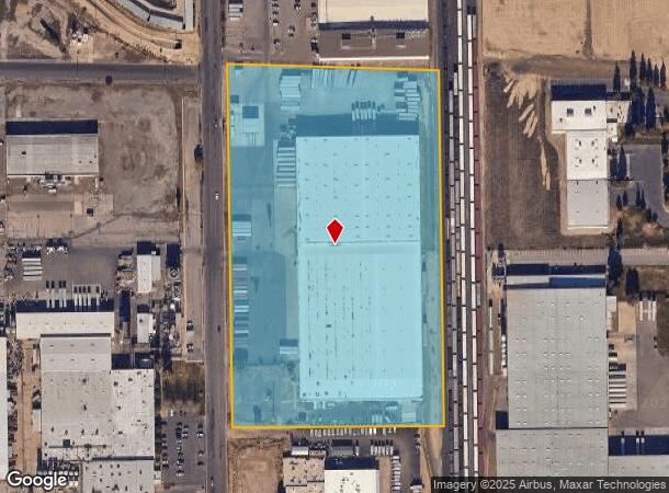
Property Record
536 Mariposa Rd, Modesto, CA 95354
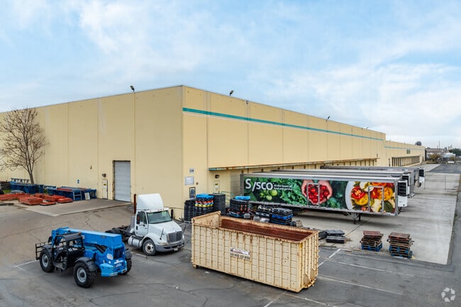

This Property Is For Sale
Current Lease Availabilities
NEARBY LISTINGS FOR SALE OR LEASE
Property Detail
536 Mariposa Rd
Warehouse
Stanislaus
X
California
06099C0345F
13.93 AC
2025
Modesto
2025
Stockton/Modesto
002002
Modesto, CA
260,484 SF
036-15-61
DEMOGRAPHICS near 536 Mariposa Rd
1 Mile
3 Mile
5 Mile
2024 Total Population
9,362
100,608
236,838
2029 Population
9,309
100,431
236,710
Pop Growth 2024-2029
(0.57%)
(0.18%)
(0.05%)
Average Age
35
37
37
2024 Total Households
2,777
32,292
75,310
HH Growth 2024-2029
(0.65%)
(0.20%)
(0.06%)
Median Household Inc
$71,462
$70,827
$70,837
Avg Household Size
3.30
3.00
3.10
2024 Avg HH Vehicles
2.00
2.00
2.00
Median Home Value
$311,732
$377,510
$389,644
Median Year Built
1983
1978
1977
Nearby Places
Map Layers
Map Styles
 Street
 Aerial
- Restaurants
- Banks
- Shops
- Fitness
- Groceries
PUBLIC TRANSPORTATION
COMMUTER RAIL
Modesto (San Joaquins - Amtrak)
DRIVE
WALK
Distance
Modesto (San Joaquins - Amtrak)
7 min
3.6 mi
AIRPORT
Stockton Metro
DRIVE
WALK
Distance
Stockton Metro
40 min
28.8 mi
Freight Ports
Port of Stockton
DRIVE
WALK
Distance
Port of Stockton
49 min
37.3 mi
Nearby Properties
Address
Land Use
TOTAL SIZE
Lot Size
Zoning
Address
Land Use
TOTAL SIZE
Lot Size
Zoning
517,008 SF
71.35 AC
Address
Land Use
TOTAL SIZE
Lot Size
Zoning
817,526 SF
17.31 AC
Address
Land Use
TOTAL SIZE
Lot Size
Zoning
373,574 SF
23 AC
Address
Land Use
TOTAL SIZE
Lot Size
Zoning
448,549 SF
58.48 AC
Address
Land Use
TOTAL SIZE
Lot Size
Zoning
151,288 SF
6.50 AC
Address
Land Use
TOTAL SIZE
Lot Size
Zoning
138,618 SF
3.99 AC
Address
Land Use
TOTAL SIZE
Lot Size
Zoning
77,382 SF
2.60 AC
Address
Land Use
TOTAL SIZE
Lot Size
Zoning
1,225,202 SF
67.24 AC
MI
Address
Land Use
TOTAL SIZE
Lot Size
Zoning
154,264 SF
7.63 AC
Address
Land Use
TOTAL SIZE
Lot Size
Zoning
482,100 SF
21 AC
Address
Land Use
TOTAL SIZE
Lot Size
Zoning
192,858 SF
10.44 AC
Address
Land Use
TOTAL SIZE
Lot Size
Zoning
775,280 SF
30.42 AC
COUM
Address
Land Use
TOTAL SIZE
Lot Size
Zoning
327,227 SF
13.52 AC
MODM1
Address
Land Use
TOTAL SIZE
Lot Size
Zoning
476,580 SF
44.60 AC
Address
Land Use
TOTAL SIZE
Lot Size
Zoning
164,740 SF
9.35 AC
Address
Land Use
TOTAL SIZE
Lot Size
Zoning
233,787 SF
14.65 AC
Address
Land Use
TOTAL SIZE
Lot Size
Zoning
98,140 SF
6.04 AC
Address
Land Use
TOTAL SIZE
Lot Size
Zoning
206,271 SF
6.94 AC
Address
Land Use
TOTAL SIZE
Lot Size
Zoning
256,014 SF
19.38 AC
Address
Land Use
TOTAL SIZE
Lot Size
Zoning
2.16 AC
Address
Land Use
TOTAL SIZE
Lot Size
Zoning
53,976 SF
2 AC
Address
Land Use
TOTAL SIZE
Lot Size
Zoning
165,196 SF
15.57 AC
Address
Land Use
TOTAL SIZE
Lot Size
Zoning
102,200 SF
9.85 AC
Address
Land Use
TOTAL SIZE
Lot Size
Zoning
447,488 SF
22.67 AC
Address
Land Use
TOTAL SIZE
Lot Size
Zoning
71,572 SF
5.35 AC
Address
Land Use
TOTAL SIZE
Lot Size
Zoning
26,592 SF
77.55 AC
Address
Land Use
TOTAL SIZE
Lot Size
Zoning
362,384 SF
19.43 AC
Address
Land Use
TOTAL SIZE
Lot Size
Zoning
318,687 SF
36.39 AC
COUM
Address
Land Use
TOTAL SIZE
Lot Size
Zoning
366,400 SF
23.90 AC
Address
Land Use
TOTAL SIZE
Lot Size
Zoning
61,640 SF
5.39 AC
The World's #1 Commercial Real Estate Marketplace
Connect with us
© 2026 CoStar Group
The information above has been obtained from sources believed reliable. While we do not doubt its accuracy we have not verified it and make no guarantee, warranty or representation about it. It is your responsibility to independently confirm its accuracy and completeness. Any projections, opinions, assumptions, or estimates used are for example only and do not represent the current or future performance of the property. The value of this transaction to you depends on tax and other factors which should be evaluated by your tax, financial, and legal advisors. You and your advisors should conduct a careful, independent investigation of the property to determine to your satisfaction the suitability of the property for your needs.