Property Record
5360 Highway 557, Clover, SC 29710
NEARBY LISTINGS FOR SALE OR LEASE
-
-
View all Clover listings for sale on LoopNet.com
Property Detail
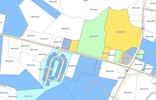
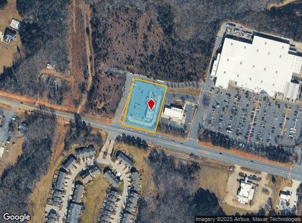
5360 Highway 557
5640000073
Survey For Lowes Home Centers Inc
Commercialnec
1.515 AC/OUT PARCEL C/HWY 557
X
York
45091C0177E
South Carolina
2025
1.52 AC
2025
York County
061709
Charlotte
6,492 SF
Charlotte-Concord-Gastonia, NC-SC
DEMOGRAPHICS near 5360 Highway 557
1 Mile
3 Mile
5 Mile
2024 Total Population
3,958
23,949
47,698
2029 Population
4,491
27,194
53,464
Pop Growth 2024-2029
+ 13.47%
+ 13.55%
+ 12.09%
Average Age
40
41
41
2024 Total Households
1,537
9,406
18,308
HH Growth 2024-2029
+ 13.92%
+ 13.94%
+ 12.39%
Median Household Inc
$86,631
$97,707
$108,979
Avg Household Size
2.50
2.50
2.60
2024 Avg HH Vehicles
2.00
2.00
2.00
Median Home Value
$377,736
$404,563
$407,167
Median Year Built
2009
2005
2005
Nearby Places
Map Layers
Map Styles
 Street
 Aerial
- Restaurants
- Banks
- Shops
- Fitness
- Groceries
PUBLIC TRANSPORTATION
AIRPORT
Charlotte/Douglas International
DRIVE
WALK
Distance
Charlotte/Douglas International
30 min
16.6 mi
Concord-Padgett Regional
DRIVE
WALK
Distance
Concord-Padgett Regional
51 min
38.1 mi
Freight Ports
North Charleston Terminal
DRIVE
WALK
Distance
North Charleston Terminal
223 min
191.5 mi
Nearby Properties
Address
Land Use
TOTAL SIZE
Lot Size
Zoning
Address
Land Use
TOTAL SIZE
Lot Size
Zoning
95 AC
RUD
Address
Land Use
TOTAL SIZE
Lot Size
Zoning
21,537 SF
3.32 AC
BDIII
Address
Land Use
TOTAL SIZE
Lot Size
Zoning
5.45 AC
UD
Address
Land Use
TOTAL SIZE
Lot Size
Zoning
38,142 SF
30.01 AC
PD
Address
Land Use
TOTAL SIZE
Lot Size
Zoning
27,372 SF
14.37 AC
RDII
Address
Land Use
TOTAL SIZE
Lot Size
Zoning
2,387 SF
4.58 AC
Address
Land Use
TOTAL SIZE
Lot Size
Zoning
14.43 AC
RDI
Address
Land Use
TOTAL SIZE
Lot Size
Zoning
27,600 SF
35.50 AC
RDI
Address
Land Use
TOTAL SIZE
Lot Size
Zoning
11,851 SF
0.65 AC
Address
Land Use
TOTAL SIZE
Lot Size
Zoning
7,840 SF
10.44 AC
RDI
Address
Land Use
TOTAL SIZE
Lot Size
Zoning
4.97 AC
BDI
Address
Land Use
TOTAL SIZE
Lot Size
Zoning
44,977 SF
24.59 AC
BDIII
Address
Land Use
TOTAL SIZE
Lot Size
Zoning
8.89 AC
BDIII
Address
Land Use
TOTAL SIZE
Lot Size
Zoning
10.18 AC
Address
Land Use
TOTAL SIZE
Lot Size
Zoning
3.89 AC
BDIII
Address
Land Use
TOTAL SIZE
Lot Size
Zoning
6,103 SF
65.50 AC
RUD
Address
Land Use
TOTAL SIZE
Lot Size
Zoning
7,878 SF
47.68 AC
UD
Address
Land Use
TOTAL SIZE
Lot Size
Zoning
3,438 SF
46.81 AC
RCI
Address
Land Use
TOTAL SIZE
Lot Size
Zoning
4,910 SF
0.69 AC
RDI
Address
Land Use
TOTAL SIZE
Lot Size
Zoning
2.92 AC
BDIII
Address
Land Use
TOTAL SIZE
Lot Size
Zoning
1,730 SF
6.88 AC
RCI
Address
Land Use
TOTAL SIZE
Lot Size
Zoning
3.53 AC
BDIII
Address
Land Use
TOTAL SIZE
Lot Size
Zoning
4,865 SF
1.03 AC
RDII
Address
Land Use
TOTAL SIZE
Lot Size
Zoning
3,816 SF
1.18 AC
Address
Land Use
TOTAL SIZE
Lot Size
Zoning
4,727 SF
1 AC
RCI
Address
Land Use
TOTAL SIZE
Lot Size
Zoning
5,254 SF
4.56 AC
Address
Land Use
TOTAL SIZE
Lot Size
Zoning
4,172 SF
1.03 AC
RDII
Address
Land Use
TOTAL SIZE
Lot Size
Zoning
2,140 SF
1.14 AC
RCI
Address
Land Use
TOTAL SIZE
Lot Size
Zoning
3,312 SF
0.72 AC
RCI
Address
Land Use
TOTAL SIZE
Lot Size
Zoning
4,578 SF
1 AC
RCI
The World's #1 Commercial Real Estate Marketplace
Connect with us
© 2025 CoStar Group
The information above has been obtained from sources believed reliable. While we do not doubt its accuracy we have not verified it and make no guarantee, warranty or representation about it. It is your responsibility to independently confirm its accuracy and completeness. Any projections, opinions, assumptions, or estimates used are for example only and do not represent the current or future performance of the property. The value of this transaction to you depends on tax and other factors which should be evaluated by your tax, financial, and legal advisors. You and your advisors should conduct a careful, independent investigation of the property to determine to your satisfaction the suitability of the property for your needs.