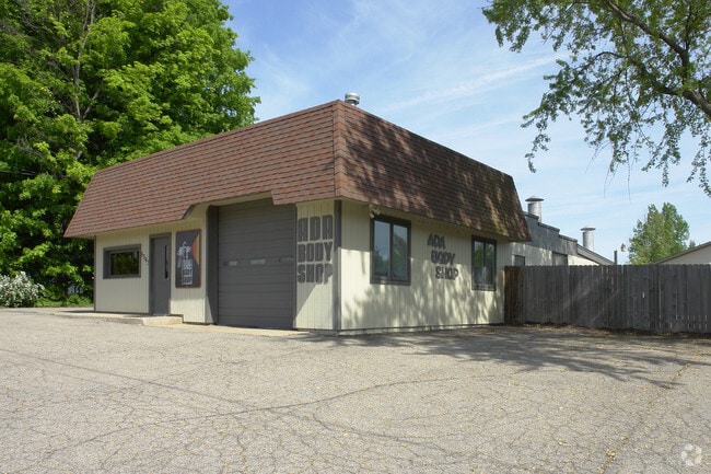
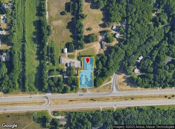
Property Record
5363 Fulton St E, Ada, MI 49301

Property Detail
5363 Fulton St E
41-15-30-251-005
411530251005 PART OF NE 1/4 COM 655.81 FT N 87D 42M 00S E & 56.03 FT N 0D 00M 00S & 332.75 FT N 87D 53M 00S E ALONG NLY LINE
Commercialnec
Kent
RR
Michigan
B and X Area of moderate flood hazard, usually the area between the limits of the 100-year and 500-year floods.
0.97 AC
2024
Ada/Lowell
2025
West Michigan
011901
Grand Rapids-Wyoming-Kentwood, MI
9,432 SF
NEARBY LISTINGS FOR SALE OR LEASE
-
-
View all Ada listings for sale on LoopNet.com
DEMOGRAPHICS near 5363 Fulton St E
1 mile
3 mile
5 mile
2025 Total Population
4,319
26,634
98,745
2030 Population
4,486
27,507
101,252
Pop Growth 2025-2030
+ 3.87%
+ 3.28%
+ 2.54%
Average Age
40
41
40
2025 Total Households
1,531
9,157
36,769
HH Growth 2025-2030
+ 3.98%
+ 3.46%
+ 2.56%
Median Household Inc
$171,139
$140,691
$108,366
Avg Household Size
2.80
2.70
2.50
2025 Avg HH Vehicles
2.00
2.00
2.00
Median Home Value
$515,244
$485,423
$425,675
Median Year Built
2000
1992
1979
Nearby Places
Map Layers
Map Styles
 Street
 Aerial
Layers
 Traffic
 Biking
Places
Listings with unknown addresses are not visible on the map
- Restaurants
- Banks
- Shops
- Fitness
- Groceries
PUBLIC TRANSPORTATION
COMMUTER RAIL
Grand Rapids Vernon J. Ehlers Station (Pere Marquette - Amtrak)
Drive
Walk
Distance
Grand Rapids Vernon J. Ehlers Station (Pere Marquette - Amtrak)
12 min
9.0 mi
AIRPORT
Gerald R Ford International
Drive
Walk
Distance
Gerald R Ford International
20 min
9.8 mi
Freight Ports
Port Milwaukee
Drive
Walk
Distance
Port Milwaukee
314 min
270.4 mi
Nearby Properties
Address
Land Use
TOTAL SIZE
Lot Size
Zoning
Address
Land Use
TOTAL SIZE
Lot Size
Zoning
277.36 AC
I
Address
Land Use
TOTAL SIZE
Lot Size
Zoning
709,488 SF
106.95 AC
LI
Address
Land Use
TOTAL SIZE
Lot Size
Zoning
126,805 SF
9.36 AC
C4
Address
Land Use
TOTAL SIZE
Lot Size
Zoning
151,708 SF
7.22 AC
C4
Address
Land Use
TOTAL SIZE
Lot Size
Zoning
Address
Land Use
TOTAL SIZE
Lot Size
Zoning
226,877 SF
22.40 AC
R2
Address
Land Use
TOTAL SIZE
Lot Size
Zoning
14,706 SF
11.25 AC
R-1
Address
Land Use
TOTAL SIZE
Lot Size
Zoning
138,278 SF
35.63 AC
R-1
Address
Land Use
TOTAL SIZE
Lot Size
Zoning
32,366 SF
34.78 AC
R-1
Address
Land Use
TOTAL SIZE
Lot Size
Zoning
154,643 SF
10.96 AC
O-PUD
Address
Land Use
TOTAL SIZE
Lot Size
Zoning
183,583 SF
9.12 AC
R-1
Address
Land Use
TOTAL SIZE
Lot Size
Zoning
8.97 AC
Address
Land Use
TOTAL SIZE
Lot Size
Zoning
209,417 SF
19.51 AC
C4
Address
Land Use
TOTAL SIZE
Lot Size
Zoning
105,029 SF
5.65 AC
C
Address
Land Use
TOTAL SIZE
Lot Size
Zoning
Address
Land Use
TOTAL SIZE
Lot Size
Zoning
110,706 SF
23.76 AC
C4
Address
Land Use
TOTAL SIZE
Lot Size
Zoning
Address
Land Use
TOTAL SIZE
Lot Size
Zoning
86,082 SF
171.94 AC
R-1
Address
Land Use
TOTAL SIZE
Lot Size
Zoning
83,464 SF
3.28 AC
SD-PRD
Address
Land Use
TOTAL SIZE
Lot Size
Zoning
33,540 SF
5.67 AC
PO
Address
Land Use
TOTAL SIZE
Lot Size
Zoning
31,736 SF
3.76 AC
C4
Address
Land Use
TOTAL SIZE
Lot Size
Zoning
81,762 SF
9.26 AC
C-PUD
Address
Land Use
TOTAL SIZE
Lot Size
Zoning
79,374 SF
12.20 AC
C-2
Address
Land Use
TOTAL SIZE
Lot Size
Zoning
14,700 SF
1.44 AC
Address
Land Use
TOTAL SIZE
Lot Size
Zoning
81,494 SF
21.36 AC
R-1
Address
Land Use
TOTAL SIZE
Lot Size
Zoning
59,200 SF
7.62 AC
C-1
Address
Land Use
TOTAL SIZE
Lot Size
Zoning
0.65 AC
Address
Land Use
TOTAL SIZE
Lot Size
Zoning
50,984 SF
2.60 AC
C-1
Address
Land Use
TOTAL SIZE
Lot Size
Zoning
67,789 SF
9.51 AC
O-PUD
Address
Land Use
TOTAL SIZE
Lot Size
Zoning
66,036 SF
4.38 AC
O-PUD
The World's #1 Commercial Real Estate Marketplace
Connect with us
© 2026 CoStar Group
The information above has been obtained from sources believed reliable. While we do not doubt its accuracy we have not verified it and make no guarantee, warranty or representation about it. It is your responsibility to independently confirm its accuracy and completeness. Any projections, opinions, assumptions, or estimates used are for example only and do not represent the current or future performance of the property. The value of this transaction to you depends on tax and other factors which should be evaluated by your tax, financial, and legal advisors. You and your advisors should conduct a careful, independent investigation of the property to determine to your satisfaction the suitability of the property for your needs.